What's New Archive
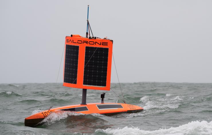
Saildrone 1020 survived freezing temperatures, 15-meter waves, 130 km/h winds, and collisions with giant icebergs to complete the 22,000-kilometer mission in 196 days. Photo Credit: Saildrone, Inc
Click on image to see animation of the sea-air CO2 from the 2019 Antarctica circumnavigation.
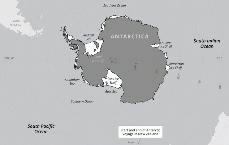
It was an audacious idea: To send an unmanned saildrone on a 13,670-mile journey around Antarctica alone, at the mercy of the most hostile seas on the planet. In winter.
“The assumption was the Southern Ocean would eat the saildrone … and that would be that,” said NOAA oceanographer Adrienne Sutton. “But we were willing to try, given the large role the ocean plays in the trajectory of climate change. Getting the Southern Ocean's carbon balance right is urgently important."
Despite a run-in with an iceberg that wrecked some of its sensors, Saildrone 1020 completed its mission on August 3 having successfully collected oceanic and atmospheric carbon dioxide measurements with an instrument developed by NOAA’s Pacific Marine Environmental Laboratory.
The 196-day voyage was the world’s first autonomous circumnavigation of Antarctica — a technological feat that was unfathomable just a decade ago.
An arduous journey around the end of the world
Saildrone 1020 and two counterparts launched from Point Bluff, New Zealand on January 19, 2019, on a mission funded by the Li Ka Shing Foundation. The three saildrones collect and transmit a range of data on weather, seal and krill populations, and levels of carbon dioxide, CO2, in the air and water.
Until recently, scientists assumed that the Southern Ocean steadily absorbed large volumes of CO2 from the atmosphere — a big contributor to the entire ocean’s uptake of up to 40 percent of the greenhouse gases driving global warming.
However, scientists also knew shifts in winds and circulation around Antarctica could alter CO2 uptake from the atmosphere, and recent measurements from instrumented Argo floats showed that under certain conditions the Southern Ocean could emit CO2 instead of absorbing it. But researchers had yet to sample vast areas, especially during stormy autumn and winter seasons.
The severe weather survived by the saildrone demonstrated why.
Pounded by storms right after leaving New Zealand, Saildrone 1020’s partners, Saildrones 1022 and 1023, were soon forced to return to port for repairs, while Saildrone 1020 pushed on through roaring winds and giant waves.
Navigating east of the Drake Passage on April 5, a collision with an iceberg damaged its atmospheric sensors and onboard camera, but left the carbon dioxide sensor intact.
“On four previous voyages in the Southern Ocean, the wings on our saildrones broke after just a few days, so we went back and built something we thought was indestructible,” said Saildrone founder and CEO Richard Jenkins. “It was a long shot, but it worked out exactly as we hoped."
Preliminary results suggest that parts of the ocean identified by the floats as potential CO2 sources were indeed emitting the greenhouse gas during winter months. Saildrone 1020 also got close enough to one of the floats to allow scientists to compare their CO2 measurements, a valuable cross-check of different robots and observing techniques.
“It was a high-risk, high reward kind of deployment,” Sutton said. “We weren’t sure it was going to make it.
Meanwhile, after being repaired and relaunched, Saildrones 1022 and 1023 are finding their own their way around Antarctica now.
Read more here: https://www.saildrone.com/news/unmanned-vehicle-completes-antarctica-circumnavigation

Some of PMEL's summer undergraduates. Top Row: Ellen Lee, Harrison Knapp and Isabelle Chan. Bottom Row: Madeline Talebi and Sam Mogen.
PMEL is excited to host seven undergraduates this summer from across the United States! They are working across various research groups studying ocean carbon, Madden-Julian oscillation impacts, meteorological data from Station Papa, fisheries-oceanography research in the Bering Sea, acoustic data from the Ross Sea, and analyzing e-DNA samples. The students are supported through NOAA, University of Washington’s Joint Institute for the Study of the Atmosphere and Ocean (JISAO) internship program, and Oregon State University’s Research Experience for Undergraduates.
Harrison Knapp is a NOAA Hollings Scholar working with Dr. Chidong Zhang on assessing the influence of the Madden-Julian Oscillation on snowpack in the Western United States. He is currently a student at the University of Southern California pursuing both a B.S. in GeoDesign and a B.A. in Earth Sciences.
Sam Mogen is a NOAA Hollings Scholar working with Drs. Jessica Cross and Darren Pilcher on exploring oxygen cycling in the Bering Sea using the Bering 10K model. He is a student at the University of Virginia studying environmental science and global studies.
Madeline Talebi is a JISAO intern working with Drs. Meghan Cronin and Nick Bond on finding and interpreting archived meteorological data from Station Papa Ocean Weather Ship between December 1949 and 1981. She is currently studying Chemical Engineering at the University of California, Irvine.
Isabelle Chan is a JISAO intern working on decreasing the degree of uncertainty between water vapor and carbon dioxide measurements with Dr. Sophie Chu. She is currently studying Environmental Science with an emphasis in Conservation at the University of North Carolina, Wilmington.
Leo MacLeod is a undergraduate at the University of Washington working with Dr. Carol Ladd on fisheries-oceanography research in the Bering Sea.
Ellie Lee is a JISAO intern working with Dr. Carol Stepien in the Genetics and Genomics Group.
Miriam Hauer-Jense is working with Drs. Bob Dziak and Joe Haxel on analyzing data from the Ross Sea hydrophones for marine mammals through Oregon State University’ Research Experience for Undergraduates program. She is a sophomore at Scripps College.
Read more about each of them and their projects here.
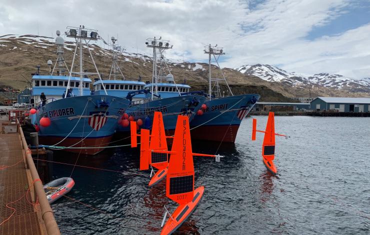
Three of six saildrones getting ready for deployment from Dutch Harbor, AK, on the 2019 Arctic mission. Photo Credit: Saildrone, Inc.
On May 16, six saildrones loaded with scientific instruments and cameras launched from a dock in Alaska's Dutch Harbor to monitor ongoing changes to the U.S. Arctic ecosystem food-chain, ice movement, and large-scale climate and weather systems.
This is the first year NOAA and NASA scientists will be working together to use the drones to survey as close to the Arctic ice edge as possible. Measurements collected this summer in the Arctic will not only be used to improve NOAA and NASA satellite ocean temperature measurements, they will also be available to global weather agencies for operational use.
While most of the saildrones will be pursuing the ice edge for the duration of the three-month mission, two other simultaneous projects will also tackle some big questions on how this cutting-edge technology can be used to collect critical observations. NOAA PMEL scientists will continue to study how the Chukchi Sea is absorbing carbon dioxide to help improve weather and climate forecasting as well as our understanding of ongoing changes in the Pacific-Arctic ecosystem. The Bering Sea is home to the largest walleye pollock fishery and the declining population of northern fur seal which primarily feed on pollock. During the summer, NOAA Fisheries scientists will use the saildrone combined with traditional at-sea tracking techniques and video cameras to get a seals-eye view during fur seal feeding trips and measure walleye pollock abundance and distribution. Read more about the work done by NOAA's Alaska Fisheries Science Center.
This is a joint NOAA mission along with the Earth & Space Research, the University of Washington's Joint Institute for the Study of Ocean and Atmosphere and the Applied Physics Lab, and Saildrone, Inc.
Saildrones have traveled about 45,000 nautical miles on Arctic missions since 2015. Follow along with drones as they collect data on fish, fur seals, changes in the Arctic ecosystem and more on the mission blog.
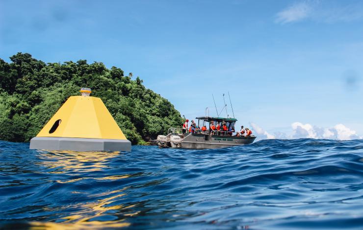
Buoy in Fagatele Bay in the NOAA National Marine Sanctuary of American Samoa with partner ship in the background. Photo credit: Nerelle Que, National Marine Sanctuary of American Samoa.
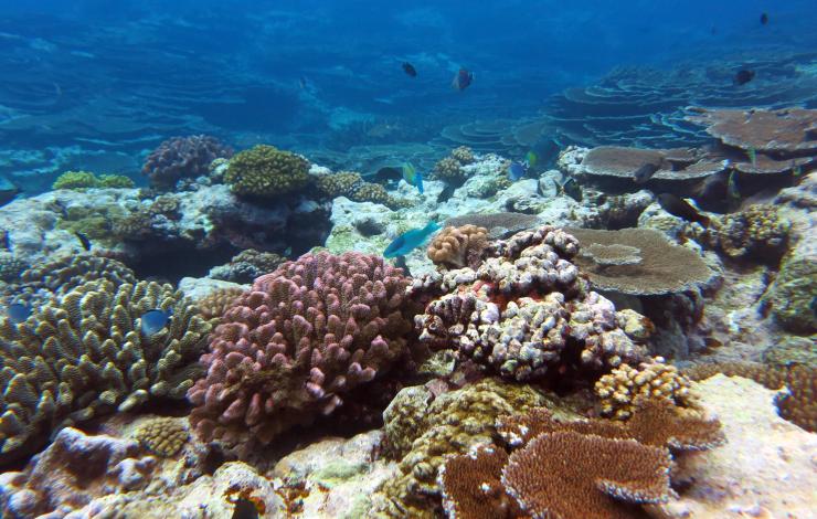
Fagatele Bay supports exceptional biodiversity, with more than 160 species of coral found within the quarter-square-mile bay.
NOAA and partners have launched a new buoy in Fagatele Bay within NOAA’s National Marine Sanctuary of American Samoa to measure the amount of carbon dioxide in the waters around a vibrant tropical coral reef ecosystem.
“This new monitoring effort in a remote area of the Pacific Ocean will not only advance our understanding of changing ocean chemistry in this valuable and vibrant coral ecosystem but will also help us communicate these changes to diverse stakeholders in the Pacific Islands and across the United States,” said Derek Manzello, coral ecologist with NOAA’s Atlantic Oceanographic and Meteorological Laboratory.
Fagatele Bay is home to more than 160 species of coral, as well as giant clams, fish, dolphins, and the critically endangered hawksbill sea turtle. Coral reefs and shellfish are particularly vulnerable to the impacts of increasing carbon dioxide in our ocean. As the ocean absorbs carbon dioxide from the atmosphere, the acidity of seawater increases. This is known as ocean acidification, which can threaten the ability of shellfish and corals to build their skeletons, hamper new coral growth and accelerate reef erosion. The loss of coral reefs impacts local economies, affecting the health of fisheries and tourism and exposing coastal communities to increased storm surge.
“The deployment of this buoy complements existing monitoring efforts in Fagatele Bay, and the data will be beneficial for all ocean management partners in the Territory,” said Atuatasi Lelei-Peau, Acting Superintendent of National Marine Sanctuary of American Samoa, “It was great to see the local resource management agencies come together to support this important project.”
Through an array of moored carbon dioxide buoys near our nation’s coral reefs, NOAA is working to improve our understanding of the impacts of ocean acidification on reefs and the species that depend on them. Each buoy collects data on carbon dioxide from surface seawater and the atmosphere as well as data on water temperature, salinity, pH, oxygen, and chlorophyll. A team of scientists also conduct long-term monitoring of the surrounding coral reef ecosystem.
“Each buoy is unique based on the location and partners involved,” said Adrienne Sutton, oceanographer at NOAA’s Pacific Marine Environmental Lab who oversees NOAA’s ocean acidification mooring network. “It takes a whole village to create and manage an ocean acidification observing site like this.”
The Fagatele Bay buoy is modeled on the ocean acidification monitoring station in Kāneʻohe Bay, Hawai‘i, which combines automatic environmental monitoring with applied science by government, cultural, academic, and citizen scientists. By deploying an ocean acidification monitoring buoy in the sanctuary, researchers are able to leverage existing monitoring and research programs to better understand the impacts of ocean acidification on coral reef ecosystems.
All data can be viewed online on PMEL and Pacific Islands Ocean Observing System (PacIOOS) websites and is available to other researchers and the public. Partners in the project include PacIOOS, the National Park of American Samoa, Department of Marine and Wildlife Resources of American Samoa, the Coral Reef Advisory Group of American Samoa, and NOAA’s Ocean Acidification Program, Pacific Marine Environmental Laboratory, Atlantic Oceanographic and Meteorological Laboratory, Coral Reef Conservation Program, Pacific Islands Fisheries Science Center, and National Marine Sanctuary of American Samoa.
Posted on research.noaa.gov on May 21, 2019.
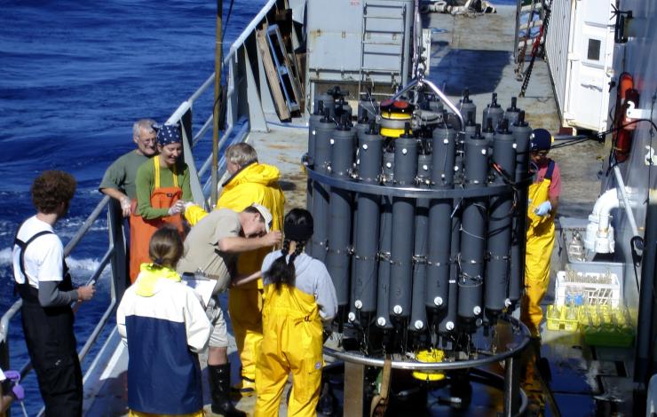
Scientists collecting samples from a CTD (Conductivity-Temperature-Depth) rosette.
NOAA scientists gathered extensive water samples from the global ocean from NOAA Ship Ronald H. Brown for the newly published analysis of carbon dioxide uptake in the global ocean.
Scientists see four-fold increase in ocean’s annual carbon uptake
The global ocean absorbed 34 billion metric tons of carbon from the burning of fossil fuels from 1994 to 2007 -- a four-fold increase to 2.6 billion metric tons per year when compared to the period starting from the Industrial Revolution in 1800 to 1994.
The new research published by NOAA and international partners in Science finds as carbon dioxide emissions have increased in the atmosphere, the ocean has absorbed a greater volume of emissions. Though the volume of carbon dioxide going into the ocean is increasing, the percentage of emissions -- about 31 percent -- absorbed by it has remained relatively stable when compared to the first survey of carbon in the global ocean published in 2004.
Ocean uptake reduces warming, but comes with a downside
By absorbing increased carbon dioxide from the atmosphere, the ocean reduces the warming impact of these emissions were they to remain in the atmosphere. However, carbon dioxide dissolved into the ocean causes seawater to acidify, threatening the ability of shellfish and corals to build their skeletons, and affecting the health of other fish and marine species -- many that are important to coastal economies and food security.
“The increasing load of carbon dioxide in the ocean interior is already having an impact on the shellfish industry, particularly along the U.S. West Coast,” said Richard Feely of NOAA’s Pacific Marine Environmental Laboratory, leader of NOAA’s West Coast acidification observing network and a co-author of the study. “We have been working with the industry to provide an early warning system against the most severe impacts of rising carbon dioxide levels.”
Rik Wanninkhof, an oceanographer at NOAA’s Atlantic Oceanographic and Meteorological Laboratory and another co-author, added: “A critical question that warrants continued observations of the ocean is if this uptake can be sustained and what might happen to the Earth’s atmosphere if the ocean is unable to absorb continued increased carbon dioxide.”
About the research
The new research was led by Nicolas Gruber of ETH Zurich in Switzerland and builds on a 2004 NOAA-led study that found that 118 billion metric tons of carbon were absorbed by the global ocean from the start of the Industrial Revolution in 1800 to 1994.
The recent findings are based on an analysis of data taken by 50 research cruises that gathered more than 100,000 water samples, including cruises by NOAA Ship Ronald H. Brown, sponsored by NOAA’s Ocean Observing and Monitoring Division. Because these cruises do not occur annually, it takes years for data representing all ocean basins to be collected and thoroughly analyzed.
Building on this extensive effort, NOAA has created an international Ocean Carbon Data System database to help researchers monitor changes in ocean chemistry. The database is managed by Alex Kozyr, a co-author of the study and scientist at NOAA’s National Centers for Environmental Information.
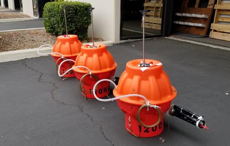
Three Deep SOLO floats prior to deployment off Hawaii In May 2018. MRV Systems manufactures the floats with assistance from Scripps Institution of Oceanography float experts. Photo Credit: MRV Systems
New research from NOAA and partners analyzing data from deep-diving ocean robots and research cruises shows that the coldest, near-bottom South Pacific waters originating from Antarctica are warming three times faster than they were in the 1990s.
“Measuring the warming occurring in these deep ocean waters helps us understand one of the drivers of sea level rise and will help to improve predictions of future sea level,” said Gregory C. Johnson, a NOAA oceanographer and co-author of two recently published research papers. As ocean waters warm, they expand, contributing to rising seas.
New autonomous ocean robots called Deep Argo floats are able to dive down to depths of nearly four miles to collect data. Operating year round, they are improving our ability to monitor how heat is taken up by the ocean. The warming ocean affects not only sea level rise, but also weather patterns and long-term climate.
The research combines temperature data taken from ship-based surveys by U.S. researchers and international partners conducted at decadal intervals with the continuous, near real-time data from an array of 31 Deep Argo floats, most of which were designed, built, and deployed by Scripps Institution of Oceanography scientists. The ship-based data show that deep ocean temperatures rose an average rate of 1-thousandth of a degree Celsius per year between the 1990s and the 2000s and that rate doubled to 2-thousandths of a degree per year between the 2000s and the 2010s. The Deep Argo floats reveal a tripling of the initial warming rate to 3-thousandths of a degree per year over the past four-plus years.
This warming rate of near-bottom temperatures is only a fraction of that of the surface ocean, but is striking for an area of the ocean long considered more stable.
This new research appearing in the journals Geophysical Research Letters and Journal of Geophysical Research: Oceans underlines the importance of expanding Deep Argo to improve the timeliness and accuracy of observations.
Working with Paul G. Allen Family Foundation, NOAA is poised to deploy Deep Argo floats in the Atlantic Ocean. With funding from the late visionary philanthropist, NOAA scientists will travel aboard R/V Petrel to deploy a large array of Deep Argo floats in the international waters off Brazil next year.

Chris Moore (left) helping emergency managers take PMEL tsunami modeling results and create easy to read public evacuation maps for the NOAA TsunamiReady program.
This week, Chris Moore with PMEL is leading and teaching a Community Model Interface for Tsunami (ComMIT) Tsunami Inundation Modeling workshop in Kingstown, St. Vincent in support of NOAA’s Caribbean Tsunami Warning Program and TsunamiReady Program. The results from a full inundation study for St. Vincent and the Grenadines (SVG) will be presented, and the outcome of the workshop will be an evacuation map for the islands of St. Vincent and Union. The workshop is facilitated by a three-member team of experts in tsunami modeling and is the first component of a Tsunami Ready Pilot Project for St. Vincent and the Grenadines.
Representatives from the SVG Physical Planning Department and National Emergency Management Organization will be participating in the process and coordinating community outreach activities and creating Standard Operating Procedures in accordance with the TsunamiReady program. The NWS TsunamiReady Program helps communities and local governments and authorities minimize the risk posed by tsunamis through better risk assessment, planning, education and warning communications.
ComMIT is an internet-enabled interface to the community tsunami model developed by the NOAA Center for Tsunami Research (NCTR) at PMEL. As of 2015, more than 325 scientists from 57 countries around the world have been trained and are using ComMIT in inundation mapping.
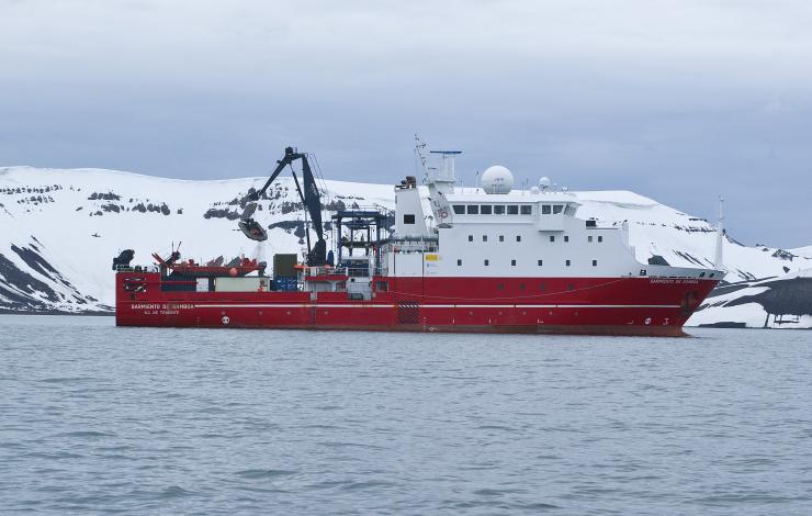
R/V Sarmiento de Gamboa in the western Antarctic Peninsula. Photo Credit: Rafa Abella
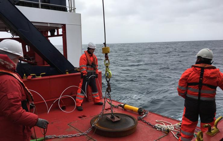
Hydrophone getting ready for deployment. Photo Credit: Lauren Roche
PMEL staff at the NOAA Cooperative Institute for Marine Research Studies at Oregon State University recently participated on a hydrophone deployment cruise aboard the Spanish R/V Sarmiento de Gamboa in the Bransfield Strait off the western Antarctic Peninsula along with colleagues from the University of Washington, Woods Hole Oceanographic Institute, Queens College and the University of Granada (Spain) from January 4 - 17. PMEL successfully deployed 6 hydrophone moorings, while the University of Washington, Woods Hole and Queens College deployed 30 ocean bottom seismometers, and the University Granada deployed 20 land-based seismic stations.
The Bransfield Strait region is a highly volcanic area, with multiple, recently active, submarine and subaerial volcanoes including the active Deception Island volcano which last erupted in 1970 damaging the Spanish Antarctic base located there. Thus the goal of the project is to assess the volcanic hazard to the collection of international polar bases located in this part of Antarctica, as well as to better understand the ocean soundscape and sea-ice dynamics in the region. Using both active and passive seismo-acoustic data collection techniques, researchers will be able to image shallow pockets of magma in the crust that are likely distributed throughout the entire area. This research is funded by the National Science Foundation Antarctica Program.
Learn more about PMEL's Acoustic Program here: https://www.pmel.noaa.gov/acoustics/
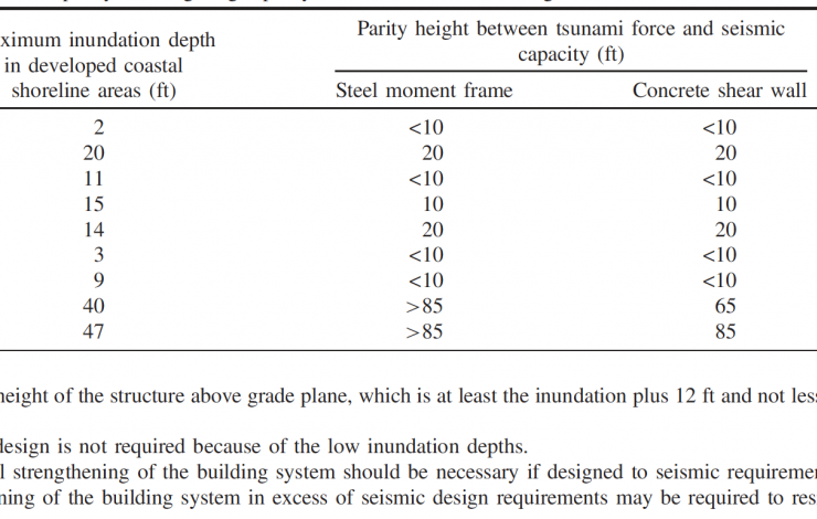
Table 1: Tsunami load to seismic capacity building height parity and threshold for Washington locations.
The Journal of Structural Engineering (JSE) awarded the Chock et al.'s "Tsunami-Resilient Building Design Considerations for Coastal Communities of Washington, Oregon, and California” as their 2018 Best Journal Paper in the Structural Hazards category.
The paper, published in August 2018 and coauthored by Dr. Yong Wei (JISAO/PMEL), was selected by a committee composed of Associate Editors from about 300 papers accepted for publication in JSE last year.
In this paper, the authors provide guidance on implementing the ASCE 7-16 tsunami design provisions by state and local jurisdictions on the west coast, and connect the technical considerations of structural engineering with community resilience objectives and land use zoning coordination. For Risk Category II buildings in California, Oregon and Washington, the paper finds that the current seismic design systemic capacity of buildings will be sufficiently strong to resist the overall tsunami design load. However, coastal buildings in several locations in Oregon and Southern Washington would not have sufficient seismic design strength to resist tsunami loads; for these locations, the authors stress the importance of implementing zoning polices and structural resiliency through tsunami strengthening (Table 1).
On February 4, Dr. Michelle McClure joined the Pacific Marine Environmental Lab as the fourth director. Michelle joins PMEL from NOAA Fisheries Northwest Science Center where she served as the Director of the Fishery Resources Analysis and Monitoring Division.
McClure brings to the laboratory 20 years of research and leadership experience with NOAA Fisheries where she made significant contributions to fisheries science for sustainable fisheries and protected resources. Under her direction, McClure expanded collaboration and research while supporting the core services NOAA provides to the West Coast fisheries industry and the Pacific Fisheries Management Council.
McClure, an evolutionary ecologist by training, joined NOAA’s Northwest Fisheries Science Center in 1999 as the Columbia River Salmon Science Coordinator. Her research has focused on conservation, population ecology, and ecosystem management. She has been a leader in the development of recovery plans for salmon and steelhead, iconic West Coast fish species. She served as a representative to the United Nations-sponsored Bay of Bengal Large Marine Ecosystem Project and helped develop scientific guidance on climate change and the Endangered Species Act.
McClure holds a bachelor of science in interdisciplinary studies (ecology) from Evergreen State College and a doctorate in ecology and evolutionary biology from Cornell University.
Please join PMEL in congratulating and welcoming Dr. McClure. We are very pleased to have Michelle join us!