What's New Archive
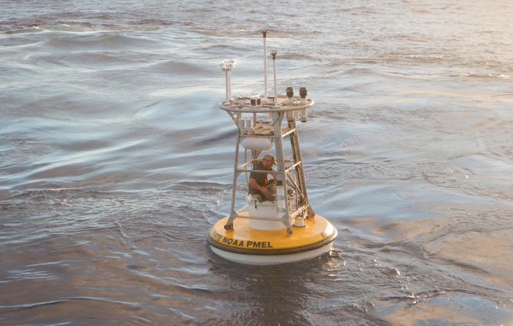
On April 8th, 2024, four scientists from PMEL and CICOES/UW flew to Kodiak, AK to board the NOAA ship OSCAR DYSON on a trip to Station Papa (50°N 145°W) for the annual Ocean Climate Stations (OCS) mooring turnaround. The OCS mooring provides critical oceanographic and meteorological observations useful to modelers, satellite validation and marine heatwave researchers, the National Weather Service, and other users in the science community.
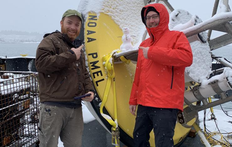
Despite encountering a mix of wintry precipitation in port, positive attitudes kept the team functioning while building and testing the buoy on a frigid (20°F) deck. Crew members assisted with various logistics, including operating the forklift and cranes. At one point, an impromptu snow mascot even joined the scene!
Unfortunately, suboptimal forecasts continued to deteriorate on the outbound voyage, and the ship was ultimately forced to turn back before operations were complete. However, the team will return for another cruise in the summer, when regional climatology favors better weather and calmer seas. In the meantime, the existing buoy continues to sample on station as preparations are made for a replacement.
Notably, the 2024 cruise provided a serendipitous opportunity for OCS to share our science. Sydney Mantell, a Knauss Marine Policy Fellow at the Ocean and Atmospheric Research’s Office of Communications, contacted OCS with the vision of crafting a story about seagoing work. From there, the narrative took shape through collaborative sessions on either end of the cruise. Sydney’s article provides a unique lens into a research scientist’s life at sea, including the logistics, preparations, and perseverance required for the job. We extend a big thank you to her for taking on the writing, social media coordination, and engaging storytelling that brings our experiences at sea to life!
Sydney’s article is available at https://research.noaa.gov/2024/05/29/life-at-sea/.
Additional articles Sydney has authored can be viewed at this link.
By: Nathan Anderson
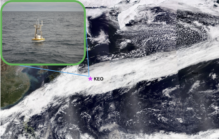
The KEO moored buoy (pink star) was deployed just in time to observe an intense atmospheric river (as shown in the satellite image) that connected the western Pacific to the east and brought stormy weather and heavy precipitation to the Pacific Northwest. Click on image to see full image. Cloud image created from worldview.
March 31, 2022: The Kuroshio Extension Observatory (KEO) moored buoy was successfully deployed by NOAA PMEL and partners, renewing an ongoing OceanSITES time series that began almost 18 years ago. First deployed in 2004, its time series was disrupted by the COVID pandemic. KEO collects vital data in the Kuroshio Extension recirculation gyre, a region known to affect the development of storms over the North Pacific before they reach the United States.
The deployment was just in time for KEO to capture the air-sea interaction process underneath an intense atmospheric river that connected the western Pacific to the east and brought stormy weather and heavy precipitation to the Pacific Northwest.
KEO carries sensors for NOAA PMEL and partners from Japan and US academic institutions that measure surface air-sea heat and momentum fluxes, along with various oceanographic variables in the upper 525 meters and near the seafloor. New this year, the KEO-2022 mooring includes dissolved oxygen sensors, a nitrate sensor, and a testbed for new biodegradable “plastic-alternative” materials from the Japan Agency for Marine-Earth Science and Technology (JAMSTEC), the University of Washington-Applied Physics Lab’s bubble and acoustic observations, and a moored CO2 system.
KEO will also play a critical role in the Japanese national program “Middle-latitude atmosphere-ocean interaction hotspot in a changing climate system” (HotSpot-2), as an ocean observatory by providing a reliable platform for new sensors and the long-term, large-scale context of intensive field campaign observations.
Learn more about the research part of the Ocean Climate Stations program: https://www.pmel.noaa.gov/ocs/KEO
This work is funded by NOAA’s Global Ocean Monitoring and Observing Program to sustain in situ global ocean observations and information in support of research, monitoring, and prediction.
By: Nathan Anderson
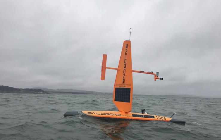
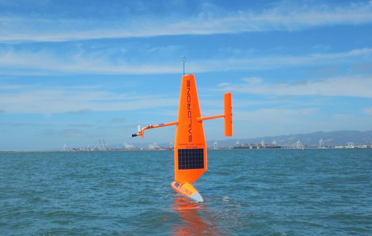
After eight straight months of sailing in the Pacific Ocean, two Saildrones have made their way back to their home port in Alameda, CA, filled with scientific data.
These unmanned observing platforms were launched on September 1, 2017 on a mission to the equator and back. The purpose of the mission was to learn more about how Saildrones might be used to improve the Tropical Pacific Observing System (TPOS), which is used by the US and partner nations to forecast weather and climate.
Overall, the project scientists consider this to have been a very successful mission. Though still sorting out a few measurement glitches, the researchers are very pleased with the data so far. Initial findings show that the oceanographic and atmospheric measurements made by the Saildrones are high quality. This platform may be a good tool for providing key observations for long-term weather forecasts.
In fact, several interesting very abrupt temperature fronts were discovered during the mission. Scientists were surprised to see the temperature of the surface sea water change by about 1°C (1.8°F) in less than 1km (0.62mi). They are now studying how these fronts impact the local meteorology and chemistry of the surface ocean. This is the sort of detail that can’t be observed from satellites, but which may influence weather patterns forming in the area.
There is still more to learn! Researchers will spend the next several months getting a good look at the data. The next Saildrone mission to the tropics is slated to begin by September 2018. Once again, two drones will sail to the equator and back, making surveys of fronts and features along the way.
You can get more information at the OCS Saildrone website, and on the mission blog.
By: Jennifer Keene
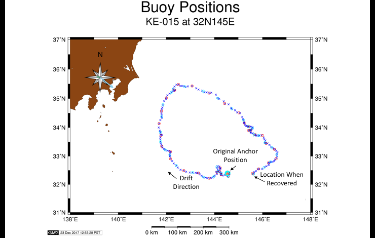
On October 19, 2017, the OCS KEO mooring broke from its anchor and went adrift. Though it drifted in the North Pacific for two full months before being rescued, the buoy stayed in the Kuroshio Extension’s recirculation gyre, and had nearly made its way back to the original anchor location to meet the rescue ship.
The KEO station is located off the coast of Japan. NOAA has maintained a surface mooring there since 2004, and Japan Agency for Marine-Earth Science and Technology (JAMSTEC) has maintained a subsurface sediment trap at KEO since 2014. The KEO surface mooring carries a suite of instrumentation to monitor air-sea exchanges of heat, moisture, momentum (wind stress), and carbon dioxide; surface ocean acidification; and upper ocean temperature, salinity and currents. The combined data sets from both moorings enable computation of the physical and biological pumps of the carbon cycle in this key region of the North Pacific. As such, the site has become a focal point for international climate research.
Researchers are now looking with interest at the data set recorded during the time when the buoy was drifting. The path taken by the buoy is interesting in itself, as it outlines the anti-cyclonic flowing recirculation gyre south of the Kuroshio Extension. Because the mooring still carried subsurface instruments down to 425m, the drifting mooring observations can be used to study the air-sea interactions along the entire recirculation gyre.
The drifting buoy was rescued and redeployed by PMEL technicians aboard a JAMSTEC ship at the end of December 2017. Now that it has been redeployed, the KEO mooring will continue to provide high quality measurements for research. In January 2018, it will be at the center of an international science expedition studying upper ocean heat and carbon exchanges. The mission includes researchers from University of Tokyo, JAMSTEC, Monterey Bay Aquarium Research Institute, and North Carolina State University.
Thanks to the joint efforts of PMEL and JAMSTEC, the NOAA KEO mooring is back where it belongs, continuing to be a central part of the research in this region.
By: Jennifer Keene
Excited to be doing our first mission using Saildrones, the OCS project has launched the OCS Saildrone Mission Blog.
This is where we’ll be posting regular updates about the mission, so be sure the check in to get the latest on what’s happening. We’ll discuss where the drones are, where they’re going, what they’re doing, and what we’re studying.
When we find something interesting, we’ll write about it here first!
For background on the Saildrones, and the purpose of this mission, you can learn more on our Saildrone page. You can also watch a great news clip about the launch, that happened on September 1, 2017.
Be sure to bookmark the blog for regular news about the latest mission developments!
By: Jennifer Keene
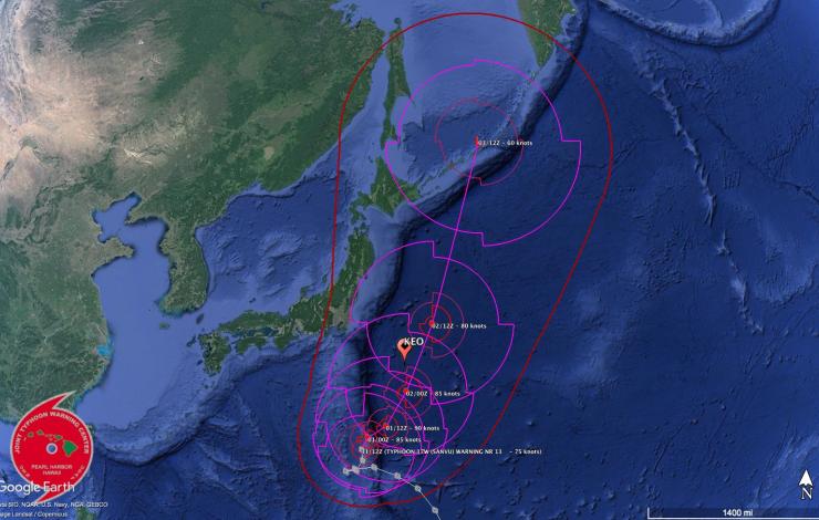
Typhoon Sanvu, the first big storm of the 2017 North Pacific season, will be passing nearly directly over the OCS KEO mooring between September 1st and 2nd, 2017.
The current forecast from the Joint Typhoon Warning Center (JTWC) has the eye passing very near the buoy, which is likely to experience some of the strongest winds. Sanvu is expected to achieve peak wind gusts to around 110 knots as it passes KEO. Impressive wave heights approaching 16m (>50 ft!) could be present near the storm’s center.
Sanvu is occurring during record sea surface temperatures at the KEO site. This is the first time in the KEO records when sea surface temperature averages have consecutively exceeded 29.3°C for more than a week. These high temperatures, coupled with low shear and strong outflow, contribute to the growing intensity of the storm.
After passing the KEO mooring, the storm is expected to accelerate to the northeast. As Sanvu becomes embedded in a mid-latitude trough, increased shear will quickly erode the storm’s strength, and it is not expect to pose much threat to land.
The KEO mooring is often in the path of large storms, and scientists use the data to analyze and improve forecasting models. Higher than average sea surface temperatures, known to contribute to cyclone intensification, were also observed preceding Hurricane Harvey, which recently caused devastating damage in Texas. By learning more about these storms and how they behave, we hope to help prepare a more weather-ready nation.
By: Nathan Anderson and Jennifer Keene
Two PMEL technicians sailed out of Yokohama, Japan on July 13th on a six-day mission to service the PMEL Ocean Climate Stations KEO mooring.
Located just south of the Kuroshio Extension Current off the coast of Japan, the KEO mooring has been in place since 2004. Equipped with meteorological and oceanographic sensors, the mooring measures the exchange of heat and moisture between the ocean and atmosphere. These exchanges affect the development of storms over the north Pacific before they reach the United States. Scientists also use the KEO data to improve hurricane predictions.
Once a year, technicians visit the site to refresh the mooring. A full set of fresh equipment is deployed. Gear that was out for the previous year is recovered, and refurbished for the following year. This has allowed the mooring to survive in very harsh conditions, providing an important climate data set for nearly 15 years.
By: Jennifer Keene
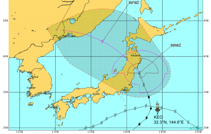
Path of Tropical Storm Lionrock, as it passed the NOAA KEO mooring, and makes it way toward Japan. Storm track image from the Joint Typhoon Warning Center.
As residents in Japan prepare for Tropical Storm Lionrock today, scientists at NOAA and the University of Washington’s Joint Institute for the Study of the Atmosphere and Ocean (JISAO) study the behavior of the storm. Lionrock is expected to make landfall across northern Japan, affecting many highly populated areas, including Fukushima and other areas impacted by the 2011 tsunami.
With funding awarded for research after Super Storm Sandy caused massive damage to the east coast of the US, NOAA and JISAO scientists aim to improve storm track models to better predict where storms will go, and how powerful they might become. To achieve this, they are using data from the NOAA Kuroshio Extension Observatory (KEO), along with model simulations performed at NOAA’s Environmental Modeling Center.
KEO is a moored buoy, located off the coast of Japan, where it is frequently in the path of storms and tropical cyclones. When Lionrock passed over KEO on Monday, wind gusts were recorded at over 81mph, and storm-induced currents approached 3 knots, some of the highest ever recorded at the site. These data, along with other measurements of the ocean state, both before and after the passage of the storm, will be valuable tools in assessing, and ultimately improving, storm prediction models.
By: Jennifer Keene
Two valuable partnerships have allowed successful servicing of the NOAA Ocean Station Papa mooring this year.
The June 2016 deployment of the NOAA Papa mooring in the Gulf of Alaska was accomplished aboard the CCGS John P. Tully, in partnership with Canada’s Institute of Ocean Sciences, Department of Fisheries and Oceans Line P Program. These long time project partners have been providing ship time and assistance servicing the NOAA Papa mooring since it was first deployed in 2007. This year, for the first time in nine years, conditions prevented the recovery of the NOAA mooring that had been deployed in 2015.
That mooring was instead recovered aboard the NOAA Ship Ronald H. Brown, which was working in the same area for Ocean Observing Initiative (OOI) operations, just weeks after the Tully cruise. Though the work schedule was shortened due to unforeseen issues, the ship was still able to accomplish all of their planned work, as well as the recovery of the NOAA Papa mooring.
Thanks to the captain and crew of the NOAA Ship Ronald H. Brown, members of the WHOI mooring group, and Oregon State University OOI technicians, who made the recovery operations a success. Grateful thanks also go to the chief scientist of the cruise, Dr. Ed Dever, who coordinated with NOAA and the NSF cruise sponsor to make this recovery possible. Continued thanks to the Line P Program for their ongoing support of NOAA mooring operations.
By: Jennifer Keene
Members of the PMEL Ocean Climate Stations Project (OCS) and the PMEL Carbon Program recently published two companion papers describing ocean processes in the North Pacific that play a role in the Earth’s climate system.
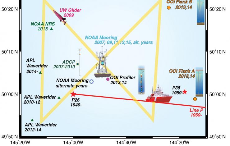
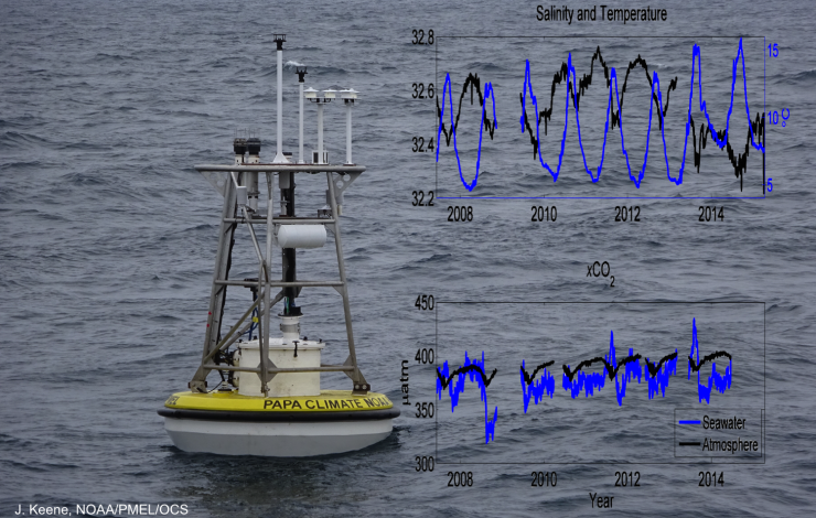
OCS Principal Investigator Dr. Meghan Cronin and her co-authors examined the exchanges of heat and salt affecting the mixed water layer of the upper ocean, since exchanges of heat and freshwater between the ocean and the atmosphere can have an effect on weather and climate. Using data from the OCS KEO and Papa moorings, satellites, Argo floats, and a glider, the authors calculated and closed the heat budget for the mixed layer at both KEO and Station Papa, and also closed the salt budget at Papa. The good agreement between the diffusive coefficients from the heat and salt budgets suggested that this coefficient could be used to help close the mixed layer budgets of other ocean properties.
Building on these results, PMEL Carbon Program scientist Dr. Andrea Fassbender and her co-authors used this coefficient to close the carbon budget at Station Papa. The authors analyzed seven years of carbon observations from the OCS Papa mooring, along with data from research vessels, satellites, and a glider. From this, they were able to study seasonal carbon exchanges, and evaluate the amount of carbon going into the deep sea. This study provided new insights about the carbon cycle and climate responses in this region.
The PMEL OCS and Carbon groups have worked together for over a decade, deploying moorings and instrumentation in the North Pacific. Both the partnership and the mooring measurements have advanced understanding of the roles of ocean processes in the Earth’s climate system.
By: Jennifer Keene
------------------------
Read the papers:
Related articles:
GBC Highlight: http://agupubs.onlinelibrary.wiley.com/agu/article/10.1002/2015GB005205/editor-highlight/
EOS Research Spotlight: https://eos.org/research-spotlights/moored-ocean-buoy-tracks-marine-carbon-cycle-variations
PMEL Feature Publication: http://www.pmel.noaa.gov/featured-publication/net-community-production-and-calcification-7-years-noaa-station-papa-mooring
PMEL What's New: http://pmel.noaa.gov/news-story/pmel-research-groups-work-together-improve-understanding-ocean-processes-north-pacific


