OCS Saildrone Mission - TPOS 2024
Funding for this TPOS-2024 mission is provided by NOAA OMAO UxSOC in support of the Uncrewed Surface Vehicles (USV) Integrated within the Tropical Pacific Observing System (TPOS) transition plan.
Mission Overview
Mission Dates: October 30, 2024 - February 4, 2025
TPOS-2024 (Mission 7) launched on 16 September 2024, with two Saildrone, Inc. uncrewed surface vehicles (USV) - SD1033 and SD1090 - departing from Alameda for the eastern/central (125°W/140°W) region of the Tropical Pacific Observing System (TPOS). Pre-mission ADCP bottom track testing and an intercomparison with an NDBC Station (Site ID: 1801593, corresponding to SD1077) were conducted as the drones departed.
The official mission began on 30 October, 2024 at 00:00 UTC when the drones arrived at their first waypoint at 10°N, 125°W. A meridional transect was conducted, sailing south to ~6°N 125°W, before redirecting the drones southwest to ~138°W, where a coordinated frontal study was performed with a University of Washington (UW) Seaglider, a wirewalker array, and an underwater profiling glider deployed and operated from the NSF-funded MOTIVE (Mixing belOw Tropical Instability waVEs) cruise by Katie Kohlman (UW School of Oceanography). Keeping a separation distance of ~5-20 km while transecting thousands of kilometers, the drones provided both high resolution and widespread coverage of important air-sea interactions in this key region of the tropical Pacific. With the hope that these missions can be repeated sufficiently frequently to capture the large-scale variations in the air-sea fluxes (and carbon dioxide uptake and outgassing measured by ASVCO2 sensors in particular) along repeat lines, we refer to these as GO-USV transects.
An equatorial upwelling experiment and intercomparison with the TAO mooring at 0°N 140°W was also conducted before the drones were swept westward in the equatorial currents. Due to La Niña, Tropical Instability Waves (TIWs) were active throughout the mission and currents were very strong. The drones ultimately sailed north to catch the eastward countercurrent in an attempt to return to the 140°W line, and observed cold pools from convective downdrafts and crossed TIW fronts along their route. The mission concluded early (after 98 mission days) on 4 February, 2025 near 5°N 140°W due to the loss of anemometer function on 15 January (SD-1090) and 18 January (SD-1033).
Both drones carried the core Saildrone, Inc. suite of sensors (e.g. wind, air temperature, humidity, barometric pressure, PAR, 0.5m SST), the ASVCO2 suite of biological sensors, solar and longwave radiometers, and additional thermistors on the hull to better resolve the temperature profile in the top 2 meters of the water column. Sensors on the hull or keel measured upper ocean currents, sea surface temperature, salinity, and conductivity. For a complete list of equipped sensors, refer to the 30 October blog post below.
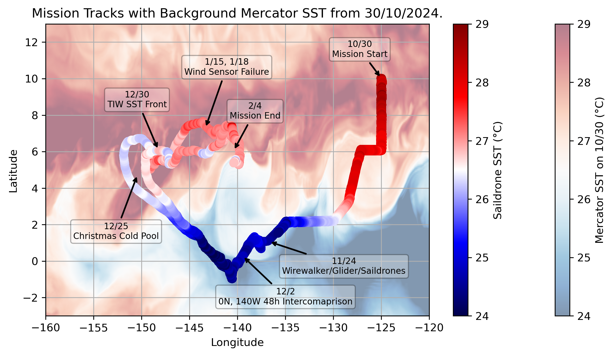
Saildrone tracks for the entire mission with background Mercator SST for day one of the mission. Some key events marked which have associated blog posts.
Mission Blog
TPOS 2024 Mission Concludes
February 5, 2025
After discussions with operations, the Saildrone team, and mission managers at OCS, the decision was made to end the TPOS 2024 mission early due to the failed wind sensors, and so near-real-time data transmissions ceased on February 4.
Blog post by Elizabeth McGeorge
Ailing Anemometers
January 31, 2025
Since reaching the peak of the TIW and entering the weaker eastward currents north of the equator, the drones have been on track to return to 140°W. The goal was to conduct further intercomparisons along 140°W with the TAO buoys and coordinate with Katie's glider.
Unfortunately, SD-1090 lost wind measurements on January 15, followed by SD-1033 on January 18. With both drones now without valid data, we are assessing whether continuing the mission back to the 140°W mooring line makes sense and whether the observations remain valuable enough to continue despite this limitation.
Blog post by Elizabeth McGeorge
SST Gradients Within a TIW
December 31, 2024
On 28-30 December 2024, the saildrones meandered around strong gradients in SST associated with a passing TIW in the area. The time series of SST from two independent sensors (SBE37 and RBR) both showed a sharp temperature change around 29 December 2024 at 11:55 UTC, when SD-1090 crossed onto the warm side of the temperature front. In the snapshot of the drone locations on 30 December 2024 at 03:00 UTC from the Mercator ocean model reanalysis product, the two drones measured an SST difference of over 0.6°C. NASA MODIS and VIIRS L2 SST also show a similar TIW structure, while the NASA L2a GPM GMI indicates the presence of deep convection over much of what appears to be the warm sector of the TIW, coinciding with missing satellite SST information.
While less prominent, an SST decrease was observed by both drones in the hours leading up to SD-1090’s abrupt front traversal. SD-1033 crossed into the coldest portion around 22:45 UTC on 28 December, while SD-1090 crossed into the coldest part of the filament several hours later at 02:45 UTC on 29 December.
Also of interest is the time series of air temperature and relative humidity during this period. Focusing on the hours just before SD-1090 crosses the warm SST front to 03:00 UTC on 30 December when it’s within the warm SSTs, SD-1090’s air temperature and relative humidity remain relatively constant. This suggests the surface layer is not yet equilibrated with the ocean and that air parcels advected over SD-1090 inherited and retained properties from the ocean waters upwind of the drone. For SD-1033, the air temperature and humidity show greater variability, suggesting pockets of colder and more humid air – possibly from cold pools like that seen on Christmas Day.
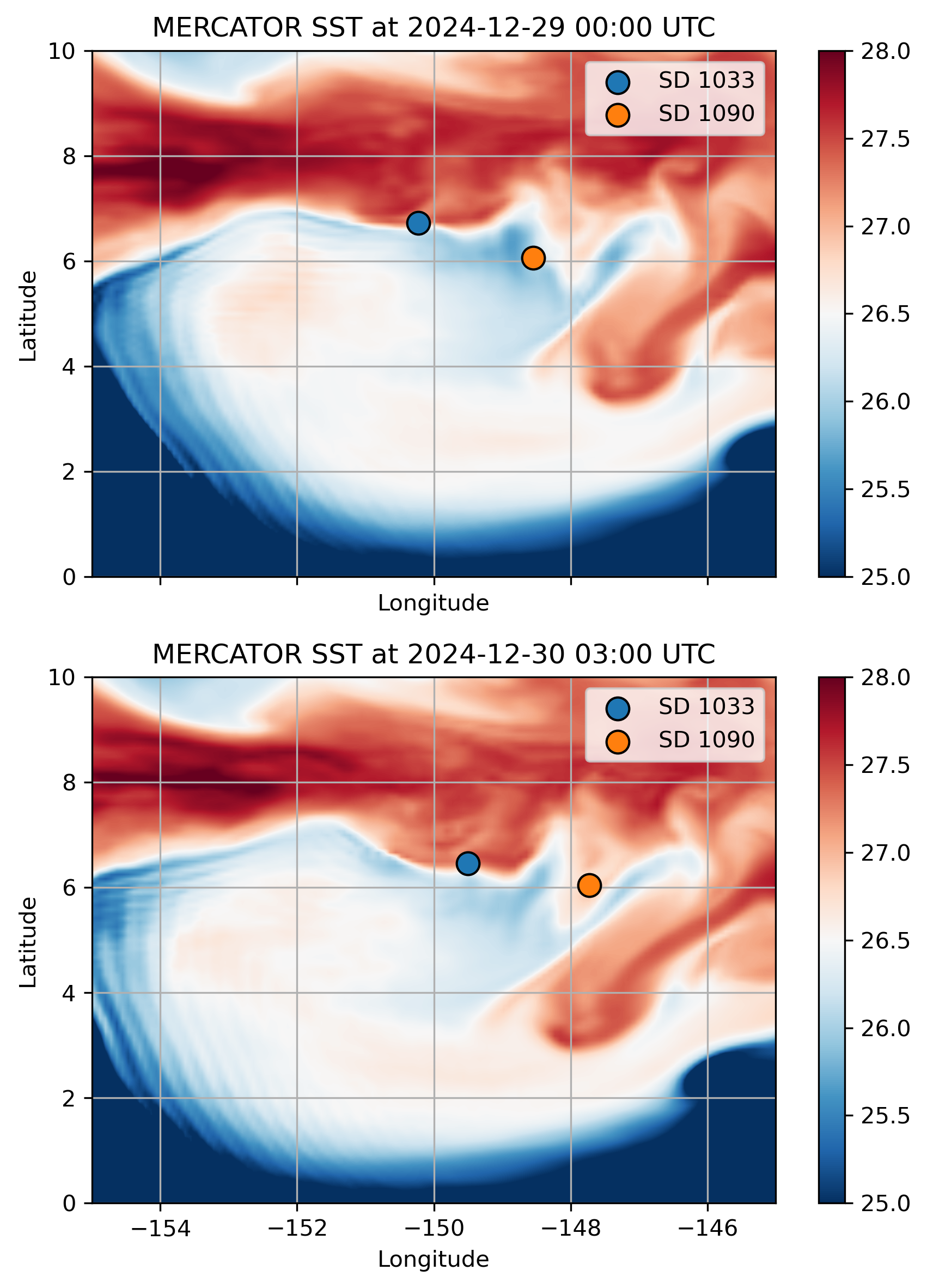
Mercator SST snapshots.
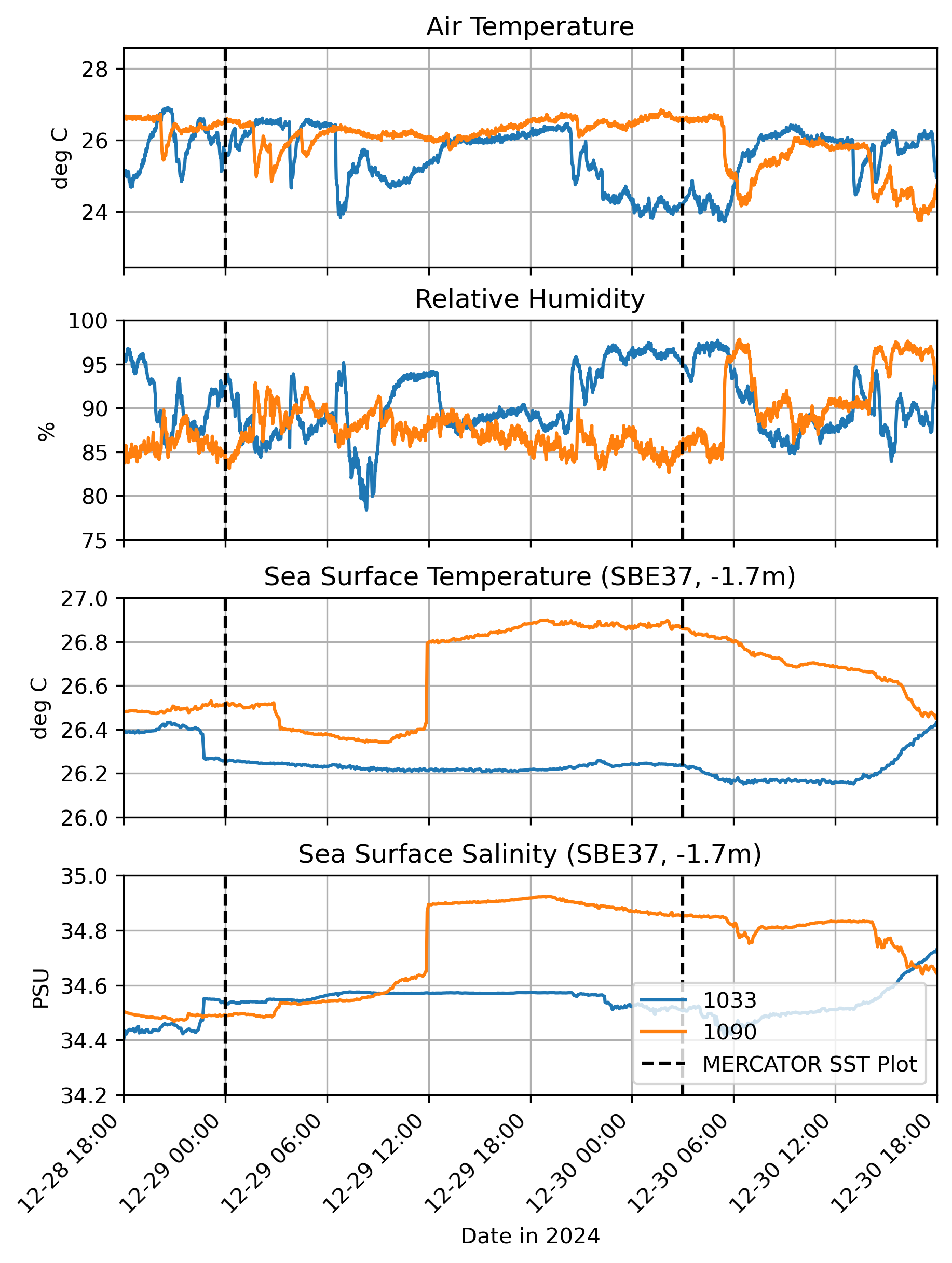
Differing conditions observed by SD1033 and SD1090 across the SST front from 12/28 to 12/30. Vertical black lines indicate the times of the two Mercator SST snapshots from the previous figure.
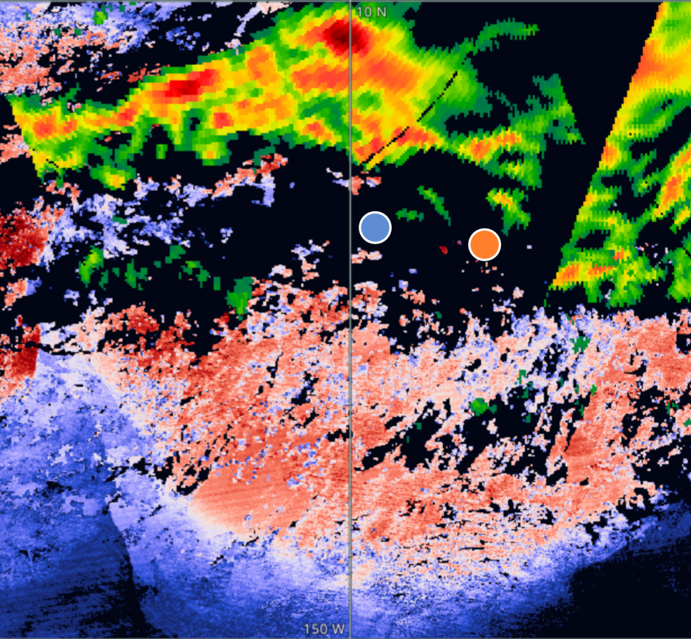
NASA L2 ascending/descending swaths of satellite SST (Terra and Aqua MODIS, Suomi NPP VIIRS) and precipitation (GPM / GMI) for 12/30/2024 from NASA Worldview. Blue and orange dots show the locations of SD1033 and SD1090 respectively.
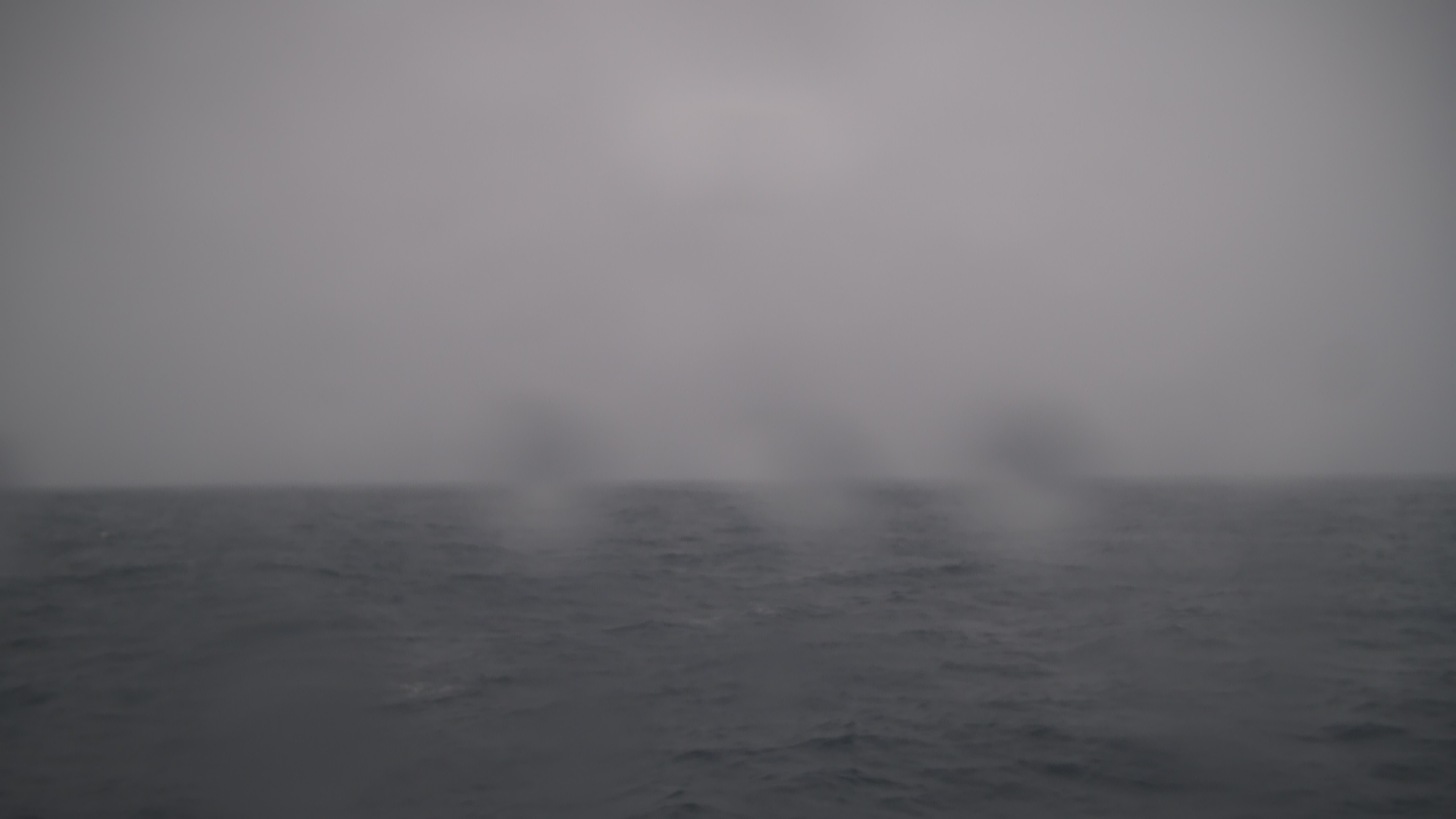
Photo from SD1090 on 12/30/2024 at 16:50 UTC showing rain in the area, confirming the NASA GPM observations above on this day. Rain continued to be detected by this drone's camera through 12/31/2024 as the drone navigated a warm patch of SST within the larger TIW (credit: Saildrone, Inc.).
Blog post by Yolande Serra
Christmas Day Cold Pool
December 27, 2024
A cold pool is formed when evaporatively cooled air within a convective system becomes denser than its environment and falls downward into the atmospheric boundary layer, where it then moves along the surface, regaining its buoyancy through surface evaporation and sensible heating. Here, we see a drop of about 2°C on Christmas Day at 20:00 UTC, accompanied by a gust of wind about 5 m/s above the background flow. Such events are being studied for their impact on the life cycle of convective systems in the Tropics and atmosphere-ocean coupling.
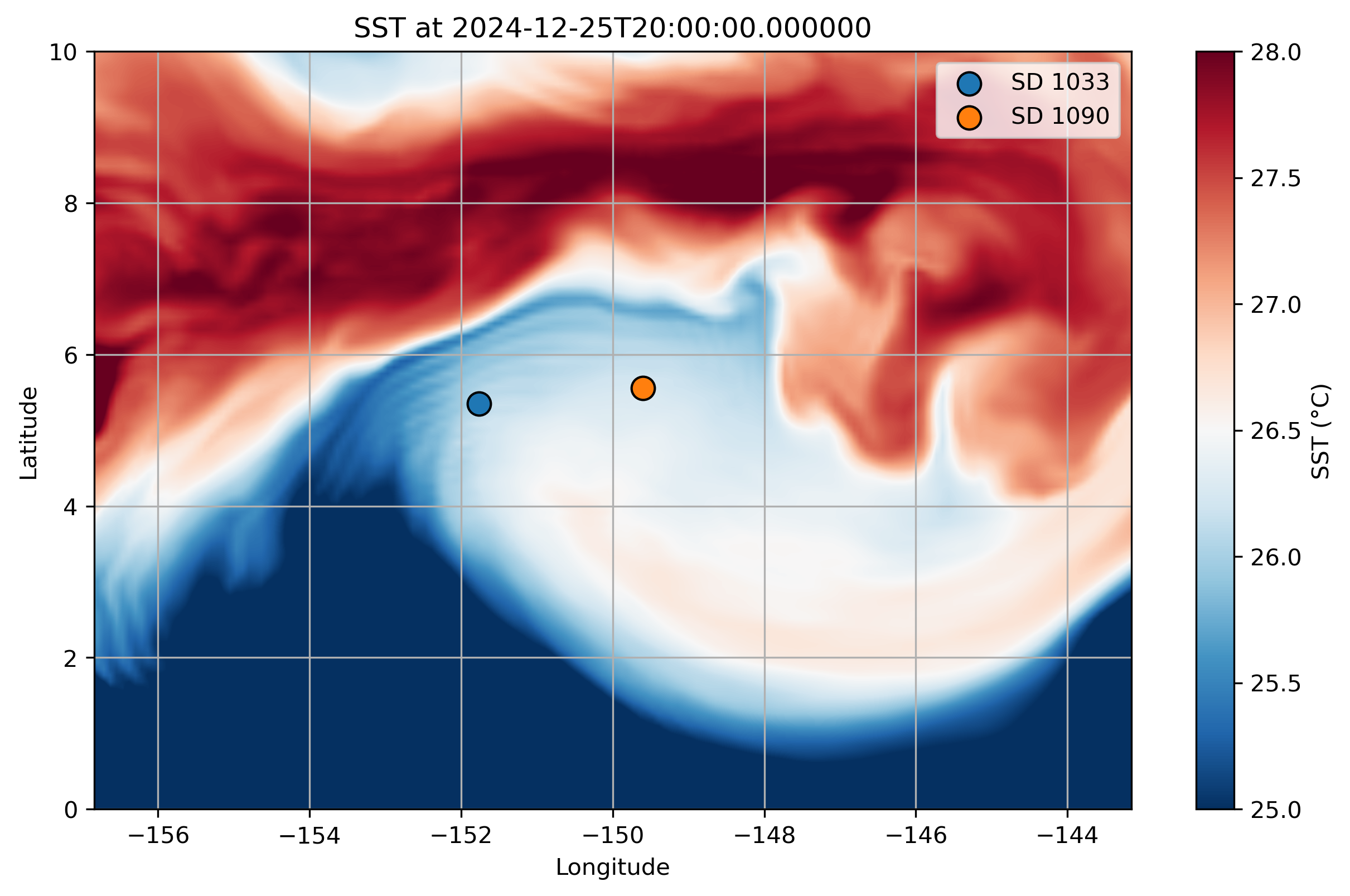
A Christmas Day Cold Pool observed by SD1090.
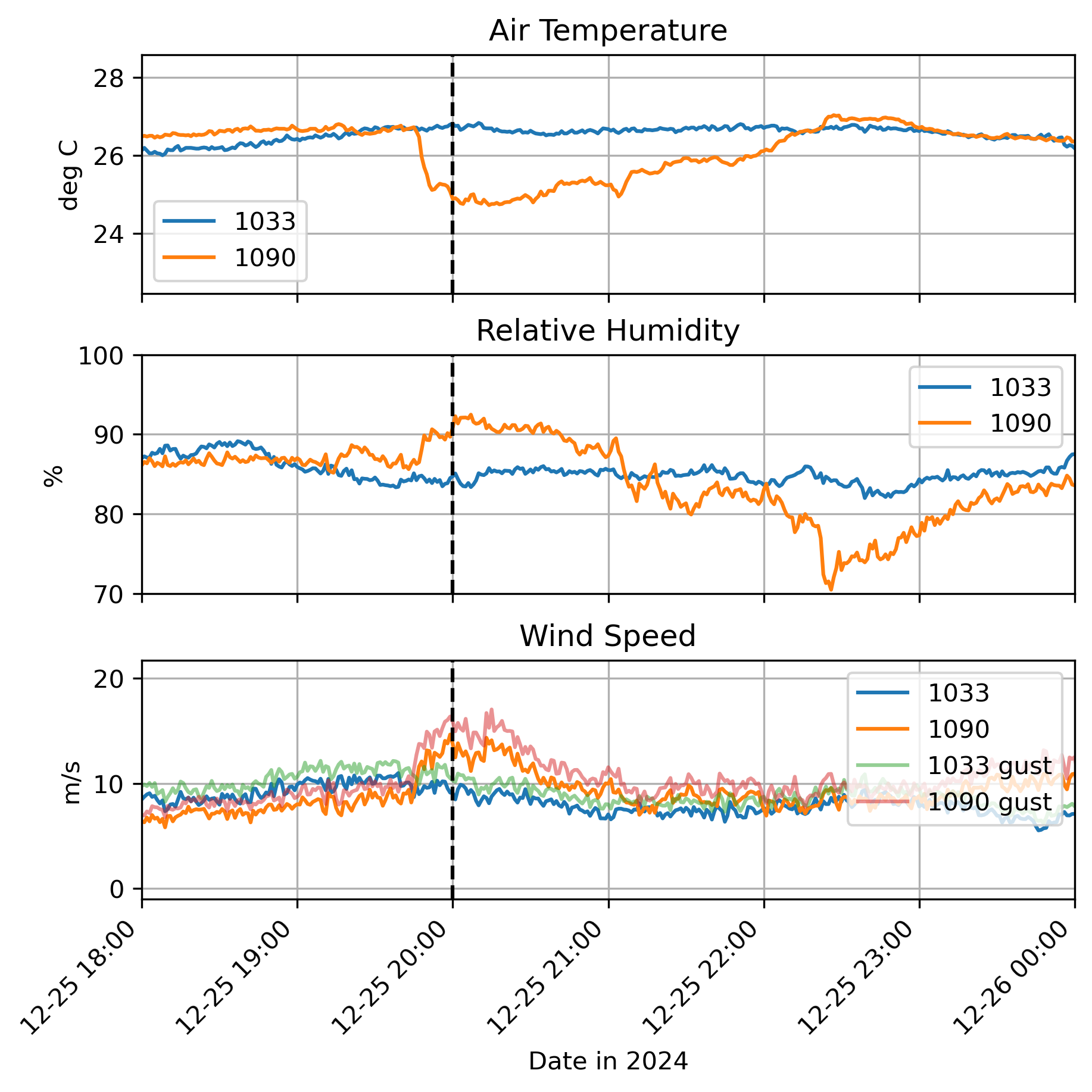
Air Temperature, Relative Humidity, and Wind Speeds observed by SD1090 during a cold pool event on 12/25/2024 (dashed black line at 20:00 UTC).
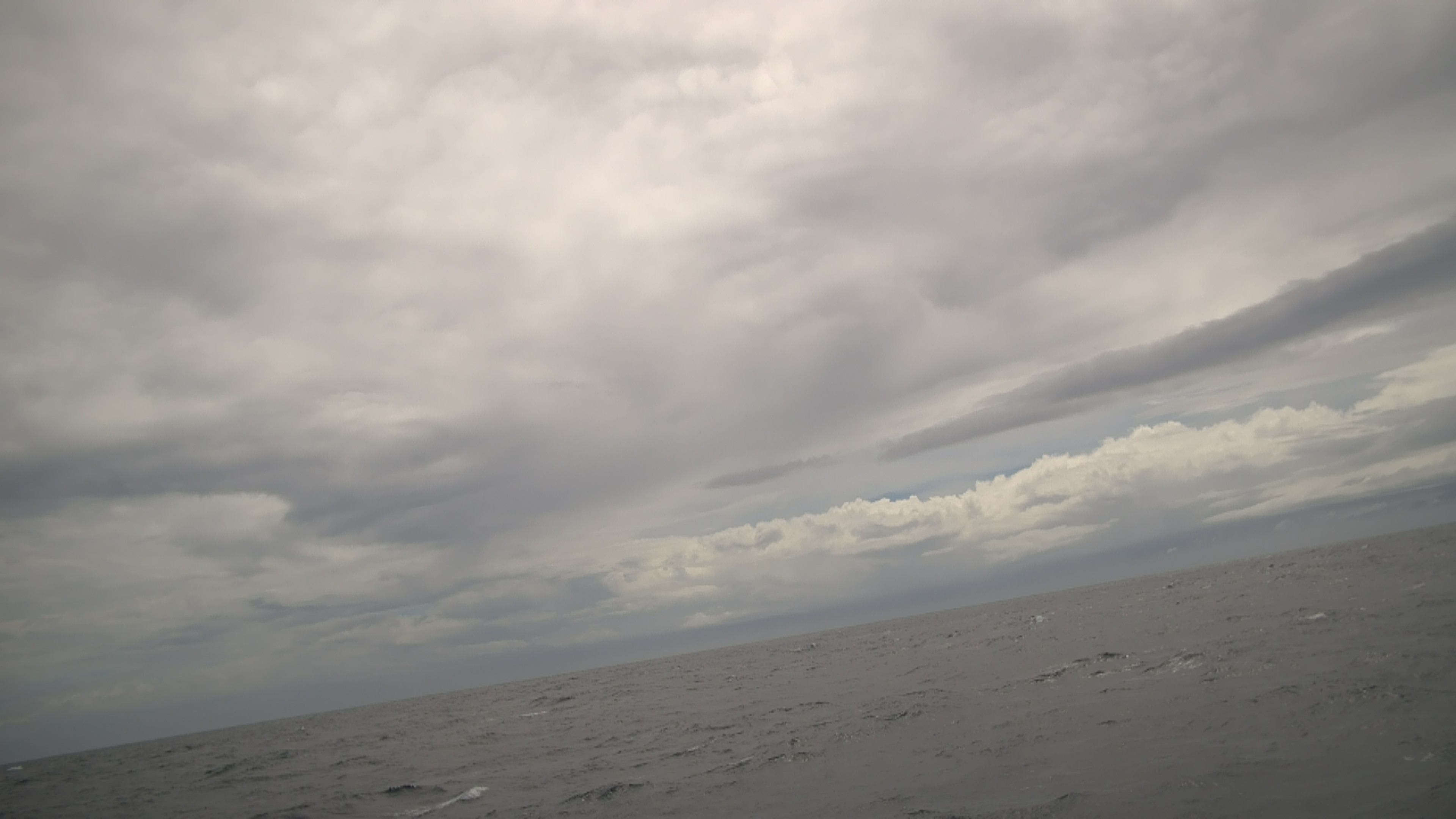
Photo of clouds observed by SD1090 during a cold pool event on 12/25/2024 at 20:50 UTC (credit: Saildrone, Inc.).
Blog post by Yolande Serra
Upwelling box-experiment and TAO intercomparison
December 13, 2024
After the experiment with the wirewalkers, the drones were tasked to head toward 0°N 140°W. They arrived on station on December 2nd, and completed a 2 day intercomparison with the TAO mooring. The primary goal here was to compare wind measurements between the platforms and conduct a short upwelling experiment. By sailing a box pattern, we can calculate horizontal velocity gradients from the ADCP and use these to estimate vertical velocity at the center of the box.
After two days on station, strong westward currents -- associated with La Niña-enhanced Tropical Instability Wave (TIW) activity -- combined with persistent easterly trade winds made maintaining position difficult, and the drones are now sailing westward with the currents. Despite these challenges, the data collected will remain valuable as the drones are now sailing along the SST front associated with the trailing edge of a passing TIW. If the drones can maintain their spacing, their positioning should allow us to calculate gradients across this front.
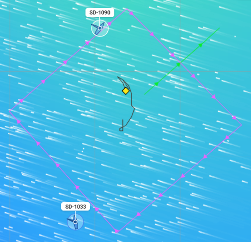
Drones sailing a box pattern around the TAO mooring at 0, 140°W from 12/2/2024 12:00 UTC to 12/5/2024 00:00 UTC.
Blog post by Elizabeth McGeorge
What a weekend!
November 25, 2024
Late on Friday, November 22nd (PST), the Saildrones rendezvoused with the array of 3x drifting wirewalkers. This meant the OCS team spent their weekends keeping our drones at a safe distance from the array, providing round-the-clock updates on wirewalker positions and new sailing routes to the Saildrone pilots. Our goal: position the two drones to sail parallel transects on either side of the drifting wirewalkers. This setup enhances spatial coverage, offering deeper insights into mixing processes.
The drones will stick with the array until they're collected by the R/V Sikuliaq later this week. After that, it's off to 0°N 140°W for an inter comparison with the TAO surface mooring and subsurface Acoustic Doppler Current Profiler (ADCP), as well as a brief upwelling experiment.
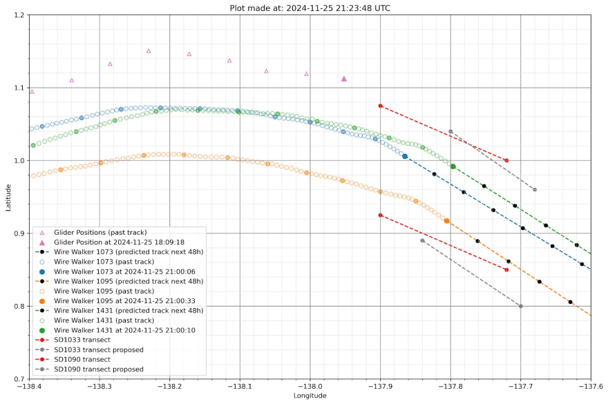
Example planning plot made by Elizabeth to coordinate drone transects as the wirewalker array drifts to the southeast.
Blog post by Elizabeth McGeorge
A letter from sea: Releasing the Pigeon
November 20, 2024
At around 4:00 am local time, SG195 (or Pigeon) was deployed off of the R/V Sikuliaq, immediately following the deployment of a drifting WireWalker array. The race begins now to meet up with the saildrones and cross the front of a tropical instability wave.
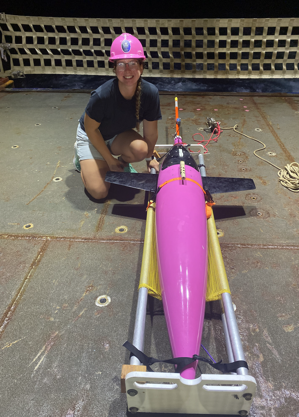
Katie with SG195 ("Pigeon") before deployment.
Blog post by Katie Kohlman
A letter from sea: Reaching Our Study Site and Observing a Tropical Instability Wave
November 18, 2024
After a week-long transit from Honolulu, HI, we finally arrived at our study site near 2°N, 140°W. Our first task was deploying Mooring C, followed by several scientific instruments including Apex and Navis Argo Biogeochemical floats, and six CPIES (Current and Pressure Inverted Echo Sounders).
On November 13, we kicked off our first process study, just as a front on the leading edge of a tropical instability wave (TIW) began to approach our location. We deployed three drifting WireWalker moorings, designed to profile and move with the upper ocean currents. The idea is that these moorings will drift across the TIW, collecting valuable vertical profiles of temperature, salinity, chlorophyll, and water velocities. During one of the deployments, we had an unexpected visitor — a curious shark circled the Wire Walker, as if inspecting our equipment!
We have been closely monitoring sea surface temperature fronts using various satellite products and models to track the frontal edge of the TIW evolution and adapt our sampling strategies in real time. On November 14, we crossed the front, witnessing a sharp temperature jump recorded by the ship's underway intake system. We believe this spike marks one of two leading-edge fronts trailing the TIW.

R/V Sikuliaq's surface temperature and salinity by the leading edge of a TIW.
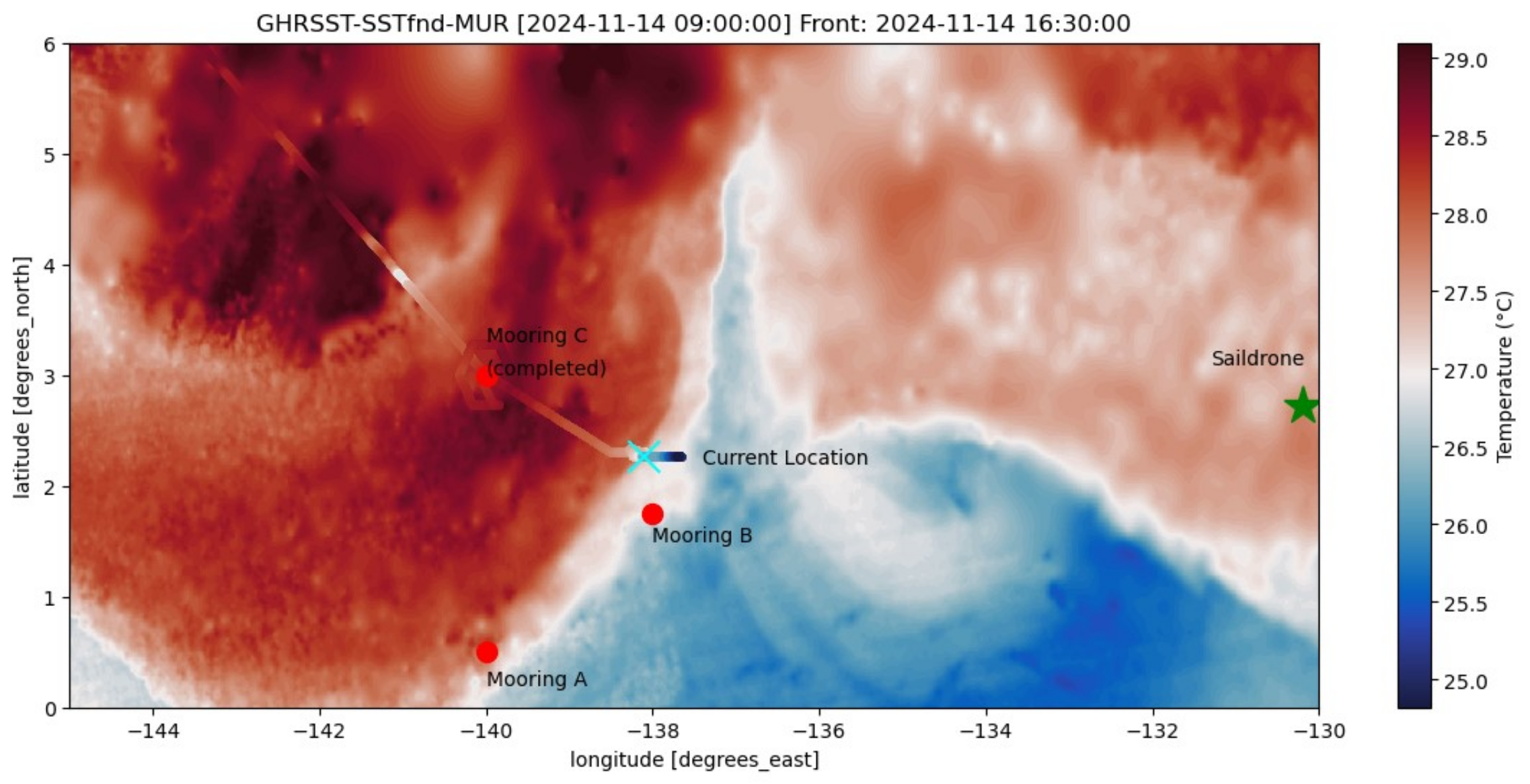
GHRSST Daily Sea Surface Temperature for November 13, 2024. Overlaid in the same color scale is the R/V Sikuliaq's intake temperature data, with the front identified on November 14th marked in cyan.
In the coming days, we’ll intensify our efforts with FastCTD (750-meter profiles every 10 minutes) and EpsiFish (750-meter profiles every 30 minutes). These tools will allow us to gather high-resolution profiles of temperature, salinity, chlorophyll, shear, and turbulence across the front.
Looking ahead, we’re eagerly awaiting the arrival of the Saildrones, which are ‘riding the wave’ towards our location. We hope their observations will complement our data, giving us an even clearer picture of the front’s behavior.
Follow the R/V Sikuliaq’s journey here.
Blog post by Katie Kohlman
Adjusting Course to Optimize Currents
November 12, 2024
Katie and the rest of the team on the MOTIVE cruise aboard the R/V Sikuliaq have made it to approximately 3°N, 140°W. We’re eagerly awaiting an update on their operations plans as they settle into their work in the region. There's still a possibility of coordinating with them near the end of their cruise, so we're keeping communication lines open.
Meanwhile, on our side, we made a strategic decision on Friday to sail west along approximately 6°N before turning back to the southwest today. This change came after several days of limited southward progress, with unfavorable currents and winds hampering boat speeds. With the new westward trajectory, we took advantage of westward currents over the weekend and are now riding the currents around an eddy to gain a helpful speed boost.
We’ll continue to adapt our path to the conditions as needed. Fingers crossed for potential collaboration with the R/V Sikuliaq crew soon!
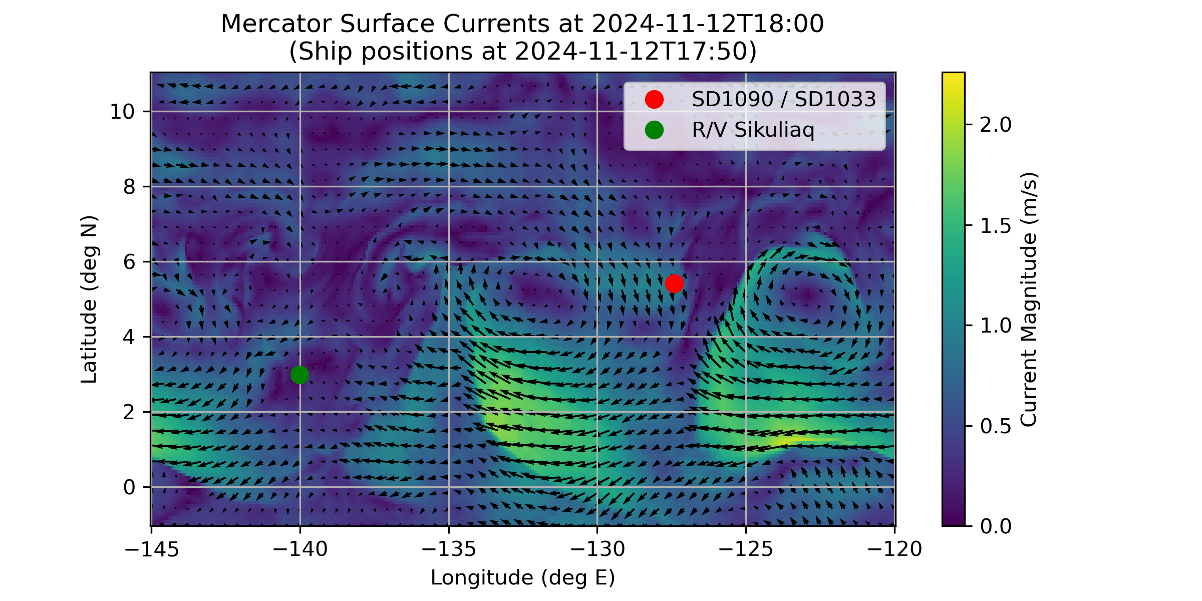
Mercator Surface and Merged Ocean Currents Forecast (plotted are the “total currents” which sums together the general circulation, tides and waves on a 1/12° regular grid).
Blog post by Elizabeth McGeorge
One week down, 15 weeks to go
November 6, 2024
We're one week into the expedition, with 15 more to go. Yesterday, we cruised past the historical TAO buoy station at 8°N 125°W. In previous years, we might have been able to do a quick intercomparison here, but unfortunately the station was decommissioned in early 2023. It’s been a challenging start; strong easterly currents have slowed our progress south, holding our average speed to just under 1 knot. Despite that, the drones have maintained their transect along 125°W and haven’t been swept further eastward.
Katie has left to join the R/V Sikuliaq, which departed Honolulu yesterday, November 5. Their transit to station (3°N 140°W) is expected to take around 7 days. Follow the R/V Sikuliaq’s journey here.
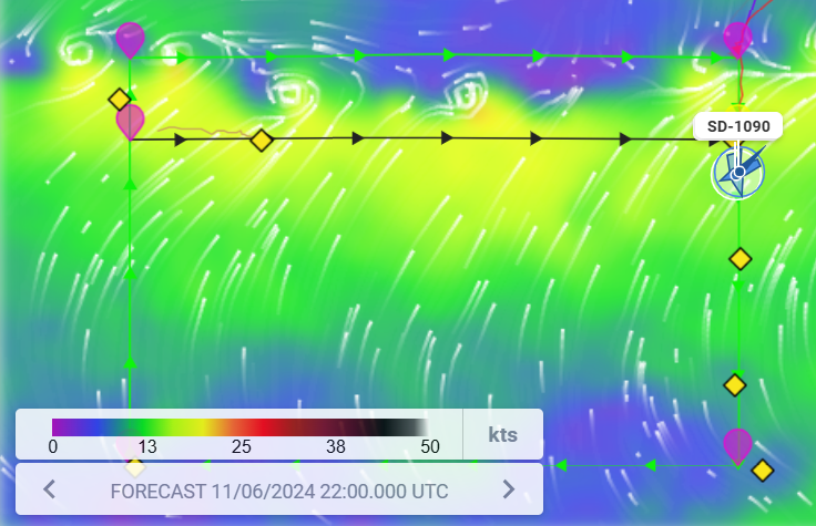
Drone positions with GFS forecast winds in the background - 11/6/2024 22:00 UTC.
Blog post by Elizabeth McGeorge
MOTIVE Cruise and Underwater Glider "Pigeon" Coordination
November 1, 2024
As mentioned earlier, we hope to coordinate our drones with an underwater seaglider that will be deployed and piloted by UW PhD student Katie Kohlman aboard the R/V Sikuliaq MOTIVE cruise this November. The Mixing belOw Tropical Instability waVEs (MOTIVE) project is investigating the question: What processes govern the observed modulation of internal waves, and possibly turbulent mixing, by Tropical Instability Waves (TIWS) in the equatorial Pacific? The MOTIVE project is a collaboration across UW, Scripps, OSU, and WHOI. The MOTIVE cruise, led by chief scientist Caitlin Whalen, will use an array of subsurface moorings (one-year deployment), FastCTDs, and wirewalkers positioned nominally near 0-3°N, 140-138°W to observe subsurface mixing beneath TIWs.
Planned Saildrone - Glider Coordination with UW Student Katie Kohlman
Katie is investigating air-sea interactions and subsurface dynamics associated with the leading edge front (LEF) of TIWs. As part of this research, she plans to pilot a UW Student Seaglider Center Seaglider, to coordinate with our two Saildrones. The Seaglider has been aptly named Pigeon, as it will complete its mission in the tropics and, much like a homing pigeon, glide all the way back home (or in our case, Honolulu, HI). The glider will provide complimentary profiles of temperature, conductivity, backscatter (470 nm, 695 nm, and 700 nm), and oxygen from the surface to 990m. Using the data collected from the drones, the glider, and complimentary MOTIVE cruise data, she plans to analyze air-sea interactions, impacts on biogeochemistry, and currents and shear associated with TIW fronts.
“I’m thrilled to pilot Pigeon, a Seaglider given a second life through the dedicated work of UW undergraduates, off of the MOTIVE cruise. It is exciting to see this refurbished glider join a collaboration of diverse autonomous tools, all working together to reveal new insights into surface and subsurface interactions and ocean dynamics!” – Katie Kohlman
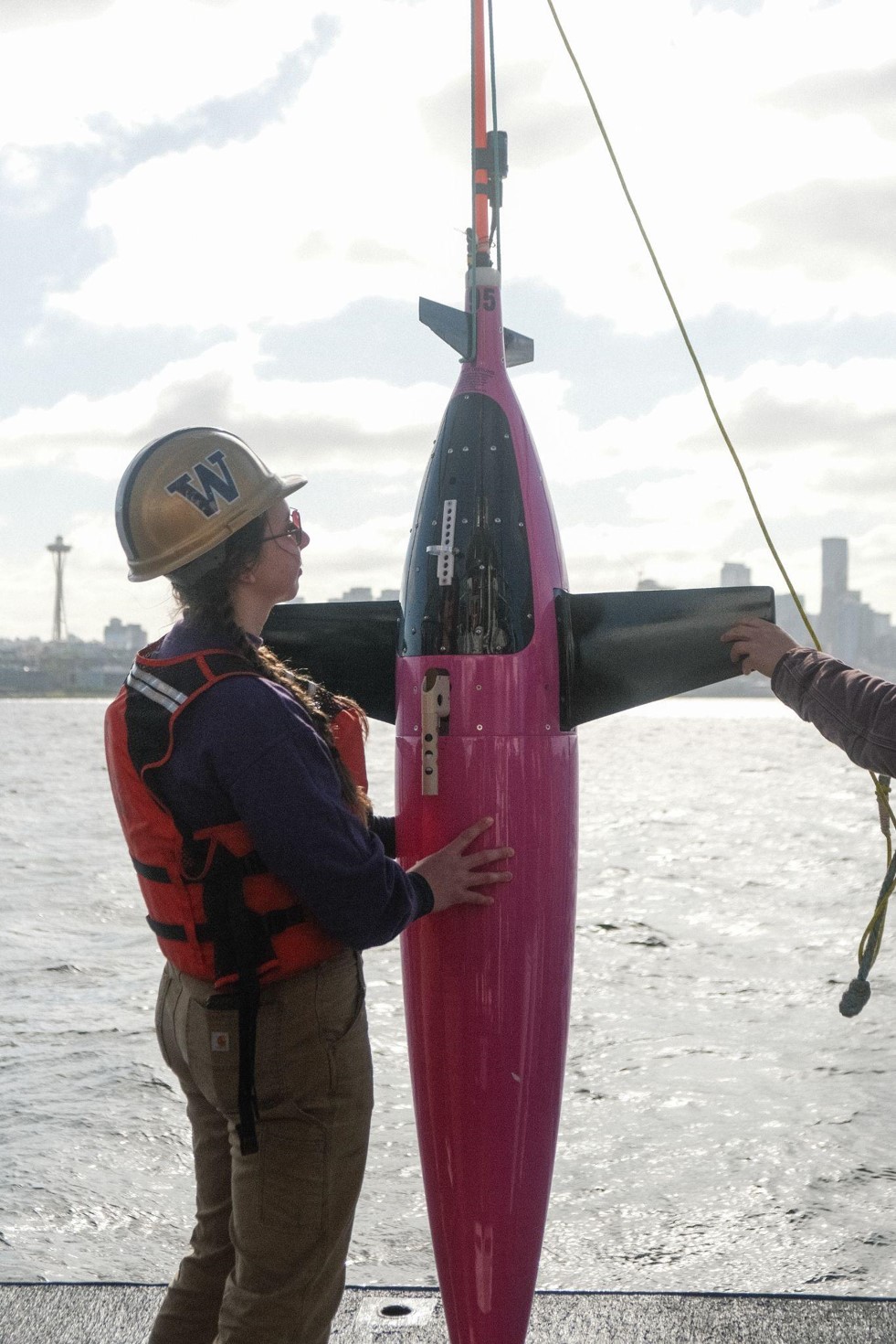
Katie Kohlman testing a Seaglider in the Puget Sound.
OCS is thrilled by this opportunity for collaboration and eagerly anticipates the deeper insights it will bring.
Blog post by Elizabeth McGeorge (with fact-checking and input from Katie Kohlman)
It's GO (USV) time!
October 30, 2024
With weather and wind always being hard to predict, our projected arrival to 10°N on Monday (28 October) was slightly off due to a combo of headwinds forcing the saildrones to tack their way south and currents stalling that minimal progress even further.
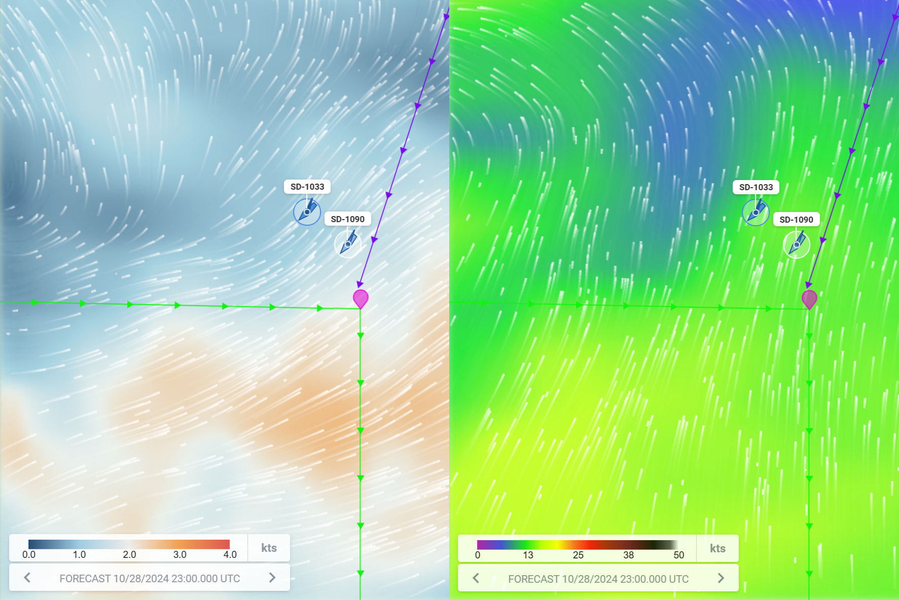
Strong north-easterly current (left) and southerly wind (right) making the transit south difficult.
No matter the slight delay, they reached the first way point (10°N, 125°W) and the 2024 PMEL TPOS Mission finally kicked off at 00:00 UTC October 30, 2024! Here’s to hoping for smooth seas and plenty of insights.
With the mission officially started, the USVs have had all sensors powered on and, battery allowing, they’ll be taking measurements every step (or splash) of the way. Each Saildrone is packed with scientific instruments designed to gather essential data on oceanic and atmospheric conditions which will help to fill gaps in our understanding of how the ocean and atmosphere interact. This year our saildrones are equipped with the following sensors:
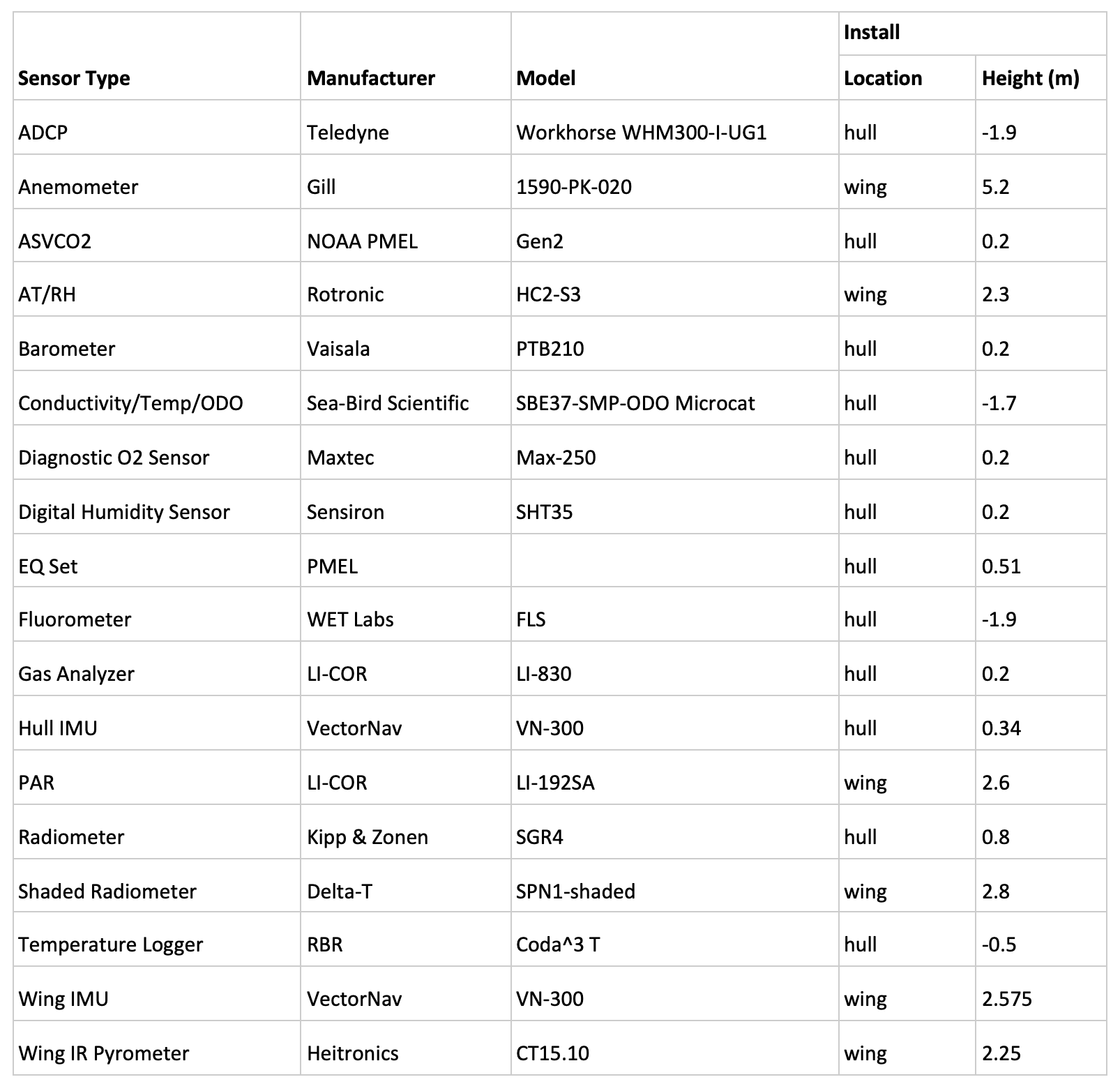
Sensor table for the TPOS-2024 mission.
In our next blog, we’ll hear from UW PhD student Katie Kohlman who is about to head off to Honolulu to join the MOTIVE cruise on the R/V Sikuliaq (with PI Caitlin Whalen). Katie is hoping to coordinate an underwater glider with our USVs to investigate frontogenesis in Tropical Instability Waves. We’ll be keeping in touch with Caitlin and Katie once they’re onboard the Sikuliaq to facilitate an observing “party” between our USVs and their operations.
Stay tuned for updates! Our USV mission is just getting started, and who knows what surprises the ocean has in store next.
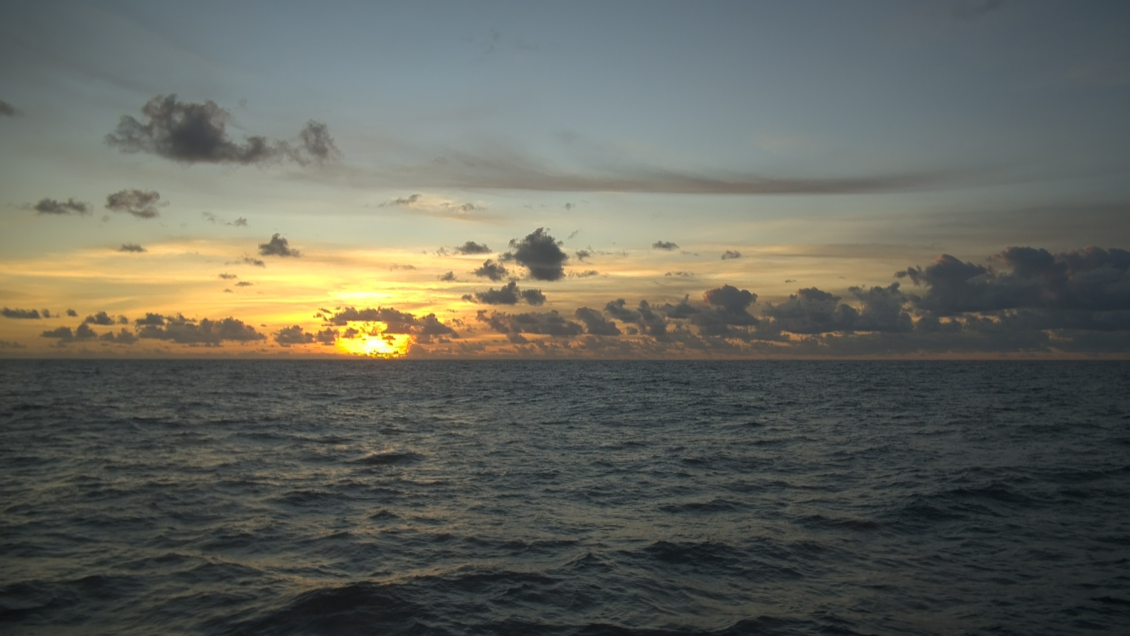
Photo from SD1033 near 17°N, 122°W on October, 20, 2024, 14:00 UTC (courtesy of Saildrone, used with permission).
Blog post by Elizabeth McGeorge
A (non)eventful transit
October 24, 2024
The past month has been quite the journey for our drones! After wrapping up the intercomparison with NDBC Station 1801593 (another saildrone!) back on September 20th, our drones have been steadily making their way south to 10°N, 125°W. As of today, they’ve just reached 13°N, 123°W, having covered 24 degrees of latitude in 34 days—that's about 1,440 nautical miles (or roughly 1,650 miles). Their average speed during the transit has been a modest 1.7 knots (nautical miles per hour).
Now, with only 180 nautical miles to go, we’re on track to hit our target of 10°N, 125°W by Monday, October 28th. Once there, all sensors will be turned on and we’ll officially kick off this year's mission. But it’s not all smooth sailing—there’s some extra excitement on the radar!
Hurricane Kristy in the Distance
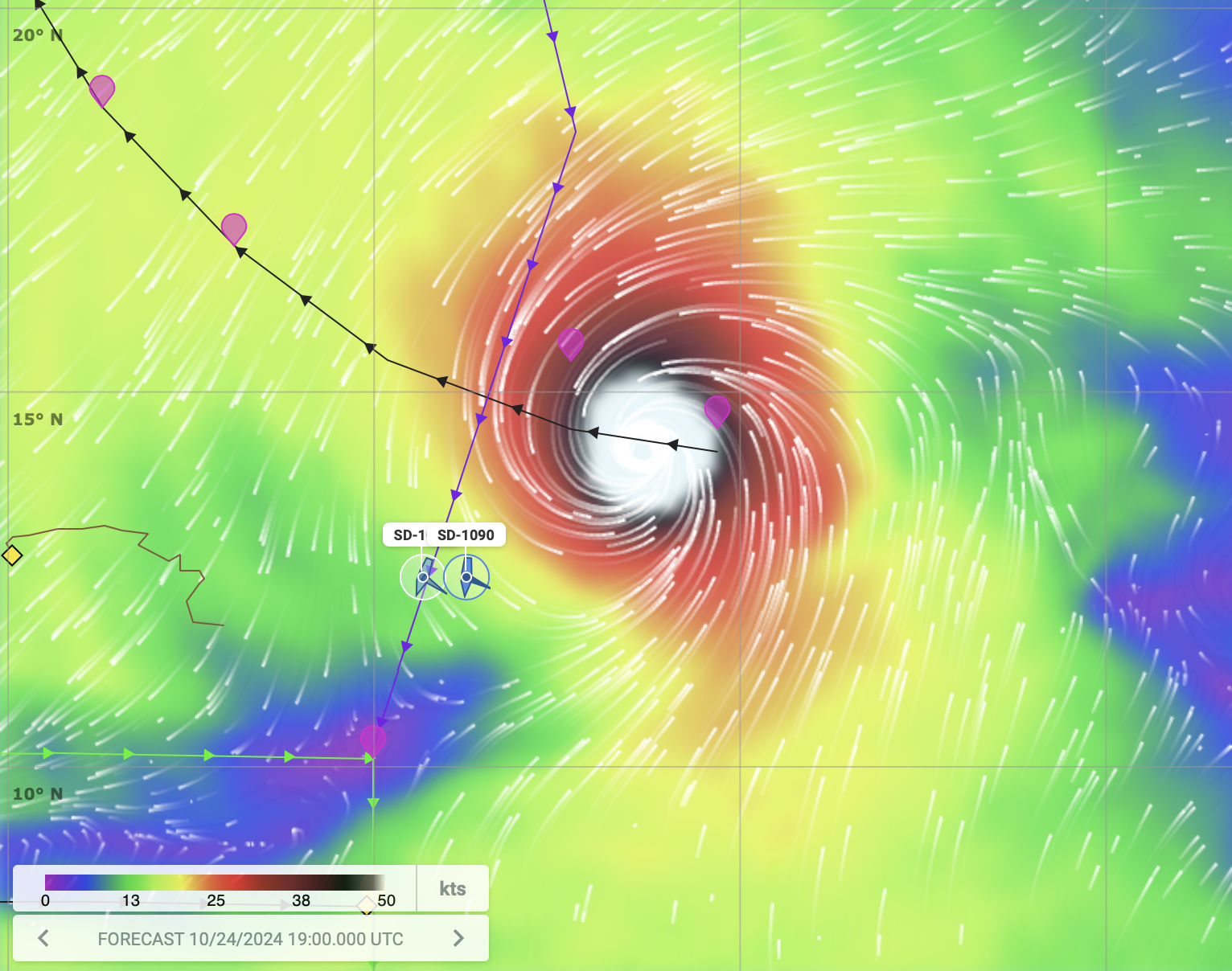
Hurricane Kristy on approach to (and narrowly missing) the Saildrones of TPOS-2024.
Hurricane Kristy formed from the remnants of Tropical Storm Nadine, and intensified upon its approach from the east. From the National Hurricane Center:
"24 Oct 2024 - 15:00 UTC ...MAJOR HURRICANE KRISTY CONTINUES WESTWARD... As of 8:00 AM PDT Thu Oct 24 the center of Kristy was located near 14.1, -120.3 with movement W at 17 mph. The minimum central pressure was 933 mb with maximum sustained winds of about 150 mph."
While it's giving our drones a bit of a speed boost right now (now averaging a whopping 3.5 knots due to the increased wind on the hurricane edge), there’s no need for concern. The forecast shows Kristy moving northwest (black track in picture), staying a few hundred nautical miles away and safely passing behind us as the drones continue south (purple planned track in picture). So, we’re expecting to avoid any direct impact.
Blog post by Elizabeth McGeorge
And they are off!
September 20, 2024
The two saildrones (SD-1033 and SD-1090) performed an ADCP bottom tracking test outside of the Golden Gate Bridge and then a ~36+ hour intercomparison with the NDBC Station 1801593 (also a saildrone). There was some variability associated with a coastal eddy that could be seen in the HYCOM fields. The dewpoint measurements from the NDBC site were also difficult to compare. But otherwise, all data checked out. On to 10N.
Blog post by Meghan Cronin
Meet the TPOS-2024 Mission Management Team!
September 5, 2024
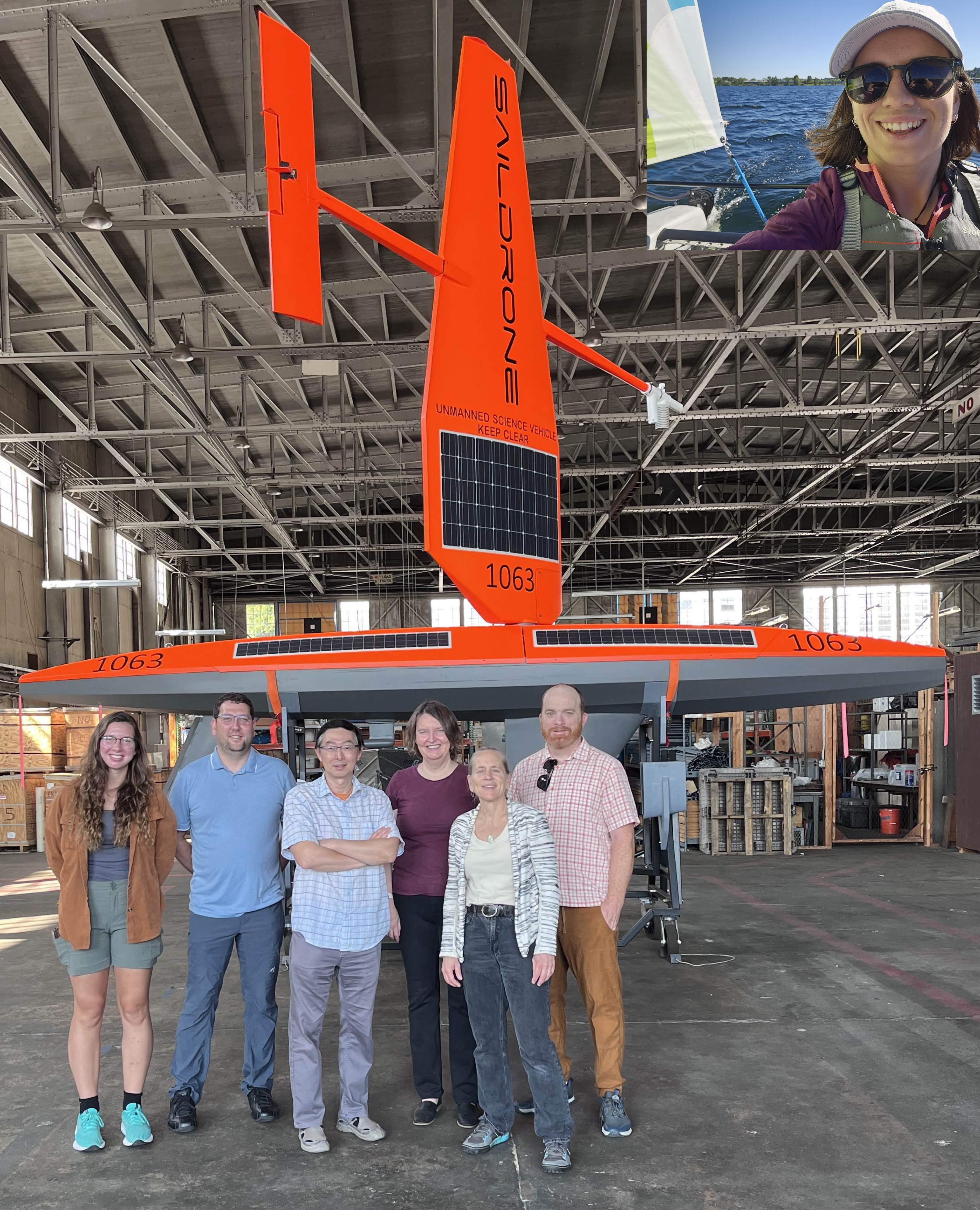
TPOS-2024 Pre-Mission Photo of the Ocean Climate Stations team with a Saildrone (In main photo, left to right: Katie Kohlman, Nathan Anderson, Dongxiao Zhang, Meghan Cronin, Yolande Serra, and Patrick Berk. In upper right photo inset: Liz McGeorge, sailing in Lake Washington last summer). The pictured saildrone is from an earlier generation of drone, and certain characteristics may differ from the deployed 2024 drones.
As lead-PI for the TPOS-2024 mission, I'd like to introduce you to a few key people on the TPOS-2024 team. Dongxiao Zhang (UW/CICOES and PMEL), co-PI for the project, is the lead Mission Manager. Other Mission Managers include myself, UW/CICOES postdoc Elizabeth McGeorge, and co-PI Yolande Serra (UW/CICOES). We will be working on a daily basis to provide waypoints for the pilots at Saildrone, Inc.
Every mission we try to learn something new about the capabilities of the Uncrewed Surface Vehicles (USV) within the TPOS. Last mission, for example, we had one drone with an EK80 system instead of an ADCP and worked with co-PI Reka Domokos (NOAA/NMFS/PIFSC) to test how fisheries applications could be integrated within the TPOS. We also used the mission to go to the heart of the developing El Nino.
In this coming TPOS-2024 mission, we will go to equatorial cold tongue region (0°N 140°W) where there will be an intensive field campaign - TEPEX - in late 2026-2028. On the northern edge of the equatorial cold tongue, extremely sharp and Abrupt! fronts can form. These fronts can undulate and have cuspy patterns as Tropical Instability Waves propagate westward. For TPOS-2024, we will perform a coordinated frontal study using our two saildrones and a Seaglider, an underwater profiling glider piloted by UW School of Oceanography graduate student Katie Kohlman. The glider will measure how the ocean stratification changes on either side of the front. The equatorial cold tongue's front is associated with air-sea fluxes that can impact the atmosphere, causing a front in the winds. These air-sea fluxes in turn can also impact the ocean. Having the glider's ocean stratification information is thus important for understanding the coupling between the ocean and atmosphere. However, we expect that coordinating the underwater glider and the saildrones will be very challenging in this frontal region due to the strong currents associated with the westward-flowing South Equatorial Current and strong currents associated with the tropical instability waves. Wish us luck!
I'd also like to introduce the team that contributes to instrumentation setup, data transfer and visualization, and engineering. Nathan Anderson (UW CICOES) is the Ocean Climate Stations (OCS) group's data manager. He will be on the front line in getting telemetered and delay mode data to users. Patrick Berk (UW CICOES) is the OCS instrument technician coordinating instrument setup, shipping & receiving, and other pre- and post-mission logistics. Those responsible for all aspects of the ASVCO2 systems aboard the Saildrones include Adrienne Sutton and Stacy Maenner (both of NOAA/PMEL). Finally, Eugene Burger (NOAA/PMEL Science Data Integration Group) and Ellen Koukel (UW CICOES) both provide critical data services to successfully land data on PMEL servers, perform data integrity checks, configure data into ERDDAP, and curate the metadata.
Blog post by Meghan Cronin


