OCS Saildrone Mission - TPOS 2023
This 120-day mission is supported by NOAA OMAO and Saildrone, Inc.
Mission Overview
Mission Dates: June 22, 2023 - November 5, 2023
TPOS Mission 6 began sea trials on May 24, 2023, with three Saildrone uncrewed surface vehicles (USV) - SD1030, SD1033, SD1079 - departing from Hawaii to undergo field testing prior to their 120-day mission across the central tropical Pacific as part of an ongoing effort to enhance the Tropical Pacific Observing System (TPOS). The official mission began on June 22, 2023, when the drones arrived at the launch site near 18°N, 155°W. This mission is in collaboration with Dr. Réka Domokos of NOAA National Marine Fisheries Service (NMFS) Pacific Islands Fisheries Science Center (PIFSC) Ecosystem Services Division (ESD) to explore the value and feasibility of combining physical and fish biomass surveys of Pacific Islands Regions. Ultimately, the goal for the TPOS/NMFS/PIFSC collaboration is to better connect the life cycle with the energy, water, and carbon cycles and thereby improve ecosystem forecasts within Earth system models.
Each mission to date has highlighted the ability of USVs to make high-resolution air-sea heat, momentum, and CO2 fluxes, in addition to multidisciplinary (meteorological, oceanic physical, biogeochemical, and fish biomass) measurements, over distances ranging from meters to thousands of kilometers, providing a unique solution for sampling data-sparse regions of the tropical Pacific. During this mission, three drones will transit to the Equator along 155°W and then return along 170°W to the convectively-active Intertropical Convergence Zone (ITCZ) region north of the Equator, before returning to Hawaii. Overall, the sixth TPOS mission aims to test the Saildrone Explorer series for: (a) supplementing shipbased fish surveys, (b) frontal studies of the oceanic and atmospheric boundary layers, and (c) equatorial upwelling studies.
Craving more than blog posts? You can find up-to-date information on the 2023 TPOS journey and access real-time data on the PMEL Saildrone dashboard.
Mission Blog
Farewell to Ocean Climate Stations
December 11, 2023
It has been a pleasure working on the Ocean Climate Stations blog for the TPOS Saildrone Missions over the last several years. I have served as a Mission Manager for the 2019, 2021, 2022, and 2023 TPOS missions, and it has been an exciting ride! It is not often that you have an opportunity to work with an emerging technology capable of transforming the ways in which we perform science. Uncrewed platforms offer new advantages such as adaptive field sampling and flexibility to mission objectives that will greatly enhance the existing observing system.
Since starting with the Ocean Climate Stations group, I have gained a new appreciation for the observing community and the many intricacies involved in collecting climate-quality measurements. I am particularly passionate about optimizing the large volume of data (both observational and numerical) being generated between the different research groups and organizations across NOAA. As I step into my new role as the Climate Observations and Monitoring Program Manager, I hope to voice the concerns of the research community and support initiatives that will provide the time and resources needed to synthesize the vast jungle of information available, thus ensuring that meaningful products are served to the public.
Thank you to those who have followed along with the blog, and best of luck to the Ocean Climate Stations team on future Saildrone missions to the tropical Pacific.
Cheers,
Dr. Samantha Wills
Establishing the Global Ocean ("Go-USV") Sampling Pattern
December 6, 2023
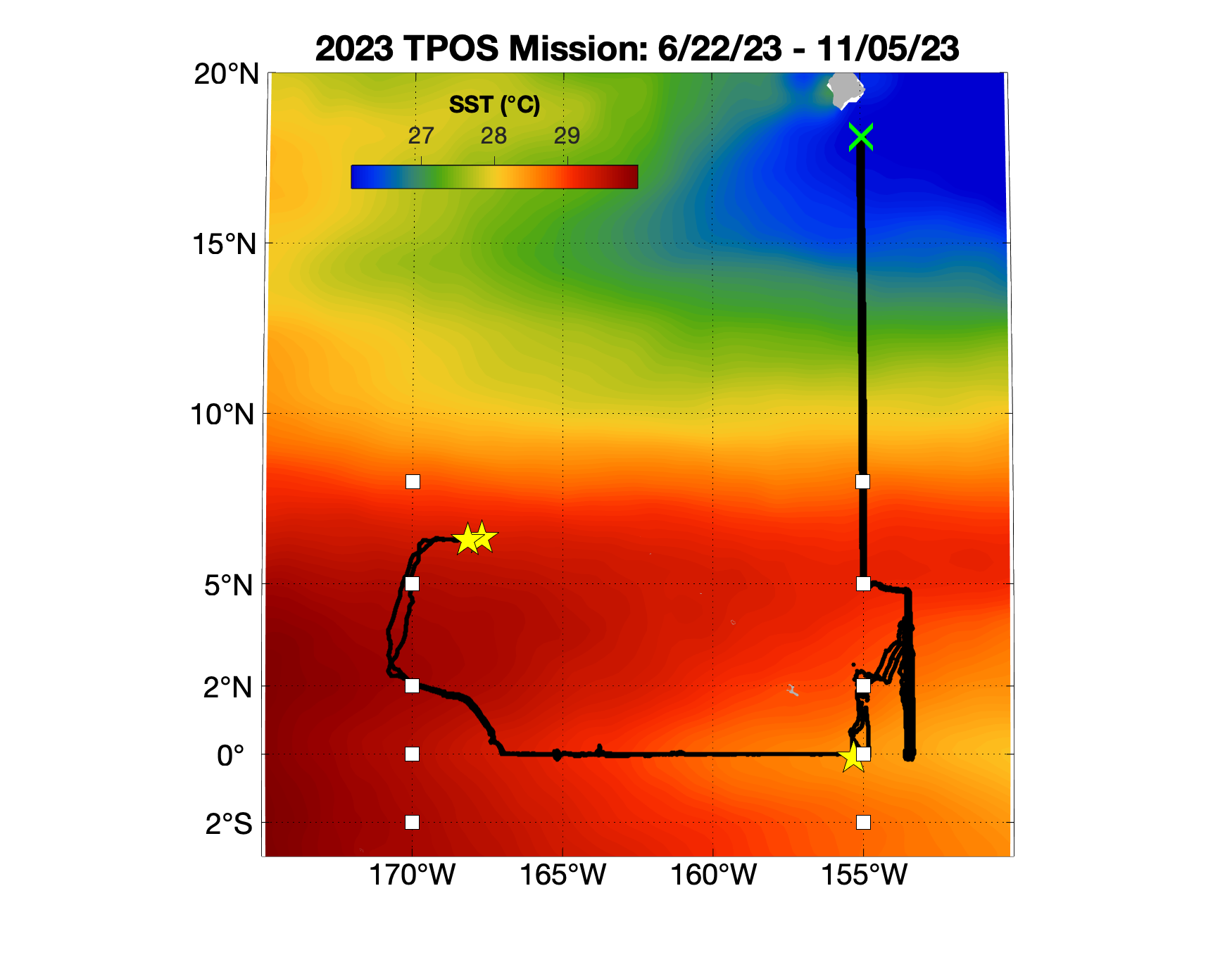
Plot of the TPOS 2023 Saildrone tracks across the central tropical Pacific study region. The tracks are plotted against the mean June 2023 - November 2023 sea surface temperature field, highlighting the El Niño conditions present during the mission. Stars indicate the drone positions when their missions ended.
After completing the intercomparison with the R/V Antea, and with three weeks remaining in the mission, SD1033 and SD1079 continued northwest from the Equator to the 170°W TAO line. The drones then transited north to ~6°N, 170°W to ride the North Equatorial Counter Current back to 155°W. The drones experienced navigational difficulties during the northern transit due to strong westward currents and weak winds, arriving near 6.3°N, 170°W on November 1 before turning east. The counter current proved to be efficient, with the drones traveling almost 5° longitude over a 5-day window before the mission was completed.
The TPOS 2023 mission officially ended in the field on November 5, 2023, with SD1033 positioned near 6.3°N, 166°W and SD1079 positioned near 6.3°N, 167°W. Recall that SD1030 was pulled from the field on September 12, 2023, while it was stationed near the 0°, 155°W TAO buoy. All three drones have since returned to port in Hawaii to perform post-mission calibrations.
The 2023 TPOS mission successfully performed the Global Ocean USV-based ("Go-USV") sampling pattern, which is expected to be an established repeat section northern hemisphere box that operates out of HI with two or more drones, forming a partnership between TPOS-2020 and NOAA/NMFS/PIFSC to combine physical and fish biomass surveys of Pacific Islands Regions in the central tropical Pacific. The mission demonstrated that ocean currents within the equatorial Pacific and North Equatorial Counter Current should be treated as "highways" for planning mission routes. The timing of the mission also occurred at an ideal time during an El Niño phase, allowing us to sample equatorial upwelling and the eastern edge of the warm pool associated with this tropical ocean-atmosphere phenomenon.
Rendezvous with R/V Antea
October 19, 2023
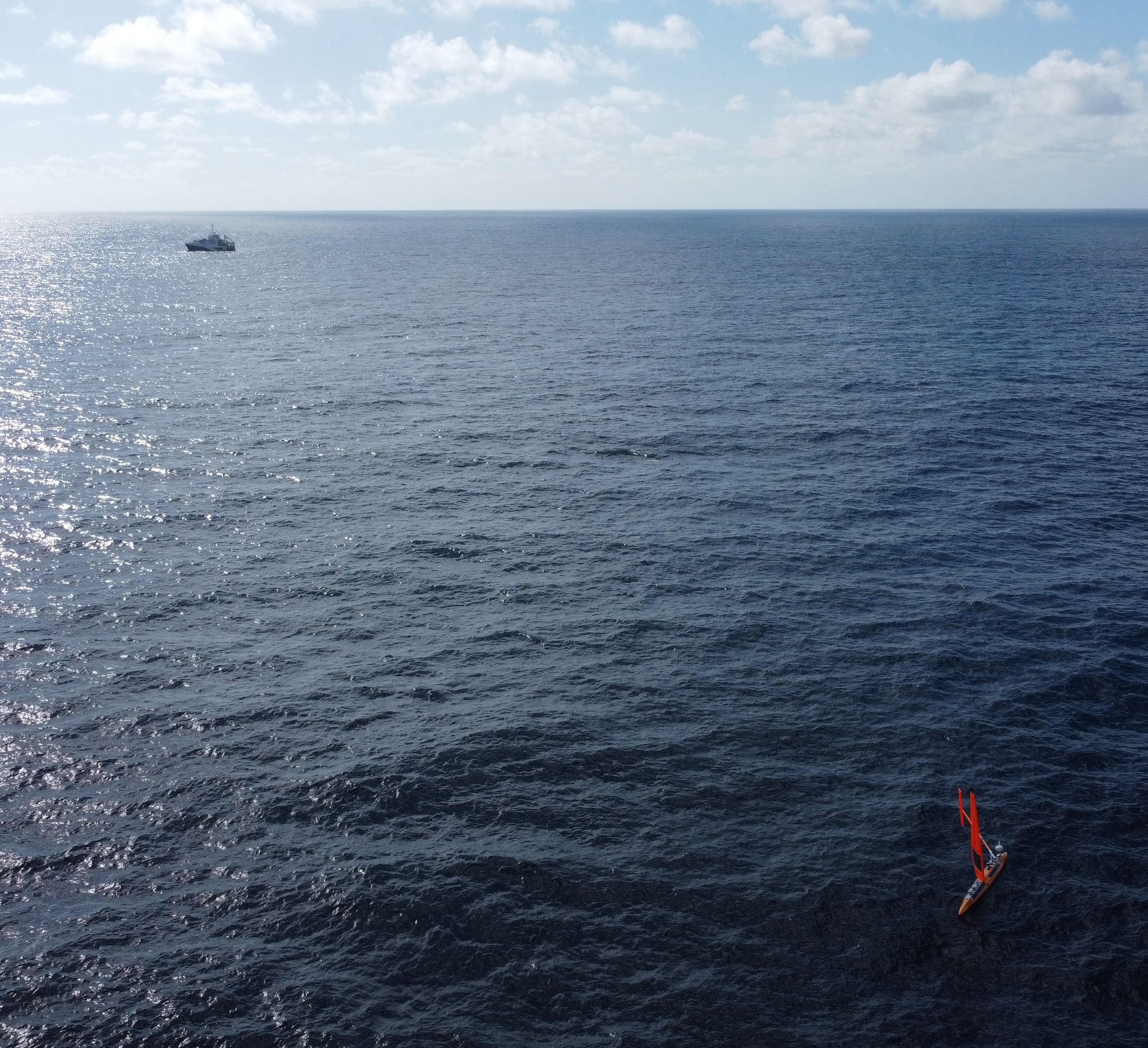
Aerial photo of the R/V Antea (background) and saildrone 1033 (foreground) near 0º, 166ºW. Picture by Guillaume Detandt, IRD-SPC.
On Monday October 9, 2023, drones 1033 and 1079 participated in a "fly-by" intercomparison with the French oceanographic vessel Antea near 0º, 166ºW. The R/V Antea began its cruise on October 1, 2023 at 0º, 155ºW as part of the WARMALIS 3 campaign to study zooplankton and micronekton of the ocean pelagic (or open ocean water column) within the larger central and western Pacific ecosystems. The campaign is a collaboration between The Pacific Community (SPC), with chief scientist Dr. Valérie Allain, and the French Institute of Research for Development (IRD), with chief scientist Dr. Christophe Menkes.
In early September, prior to the cruise, the three drones conducted quick intercomparisons against the 0º, 155ºW TAO buoy before continuing west along the equator. Unfortunately, drone 1030 was unable to continue west due to emerging navigational issues, and it went off mission at 1630 UTC on September 12. By October 1, drones 1033 and 1079 had transited to ~0º, 165ºW.
The plan for the R/V Antea was to sail west along the equator and sample every 2º longitude to 0º, 146ºE. Given that the drones were positioned downstream along the path of the R/V Antea, our team took the opportunity to coordinate with Drs. Allain and Menkes in planning a side-by-side intercomparison with the ship when it arrived on station at 0º, 166ºW on October 9 for ~12 hours. The goal of the intercomparison was to ground truth EK80 echosounder observations between drone 1079 and the ship, as well as compare drone 1033 ADCP and ocean/meteorological measurements.
We look forward to analyzing the results of the successful ship-saildrone intercomparison, and we are grateful for the careful coordination between our Saildrone, Inc. pilots and the crew of the R/V Antea!
TPOS Collaborations with the Mesopelagic Scientific Community
September 26, 2023
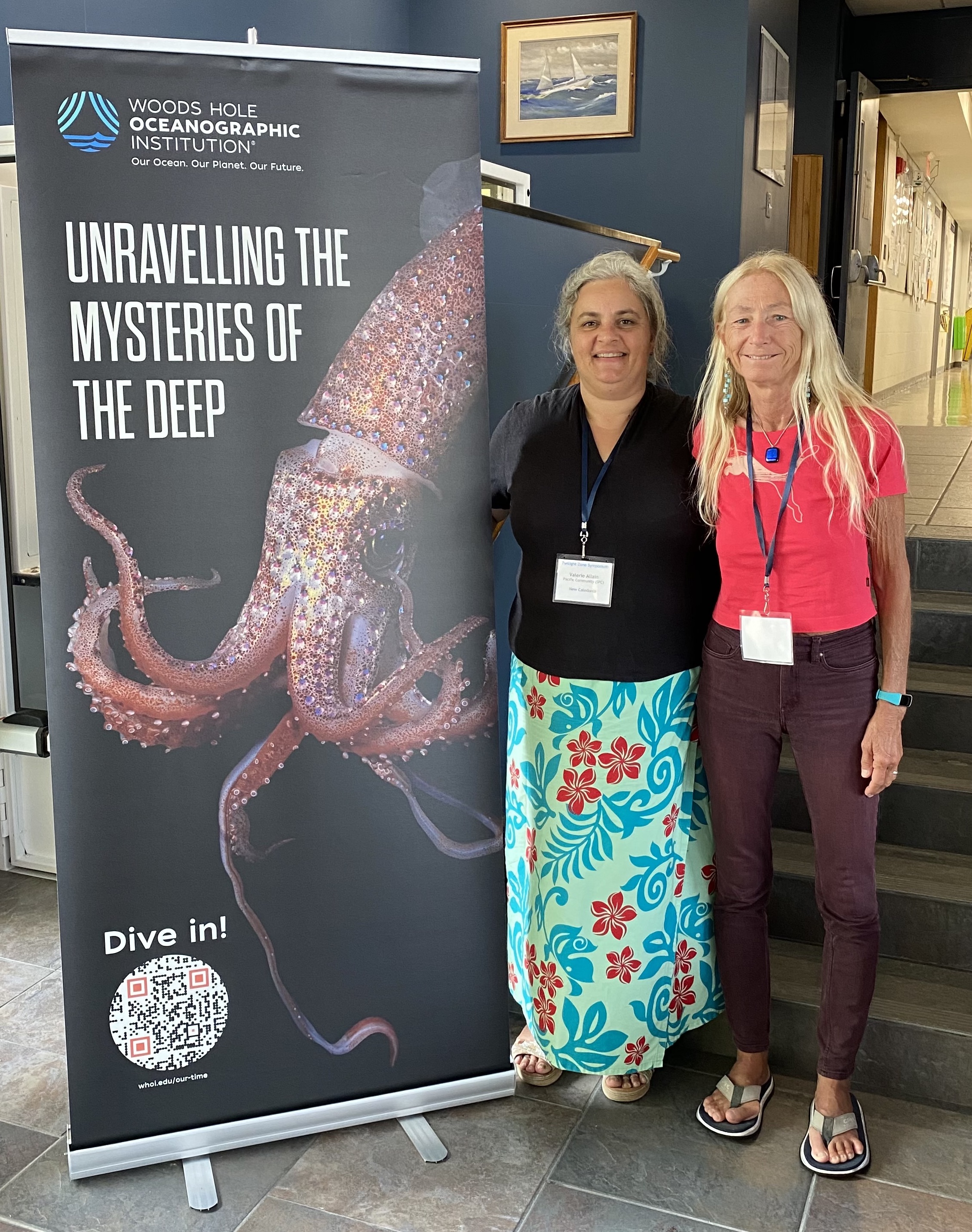
Dr. Valérie Allain (left) of The Pacific Community and Dr. Réka Domokos (right) of the Pacific Islands Fisheries Science Center in attendance at the Ocean Twilight Zone Symposium hosted by the Woods Hole Oceanographic Institution (WHOI) in Woods Hole, MA USA.
Dr. Valérie Allain, a Senior Fisheries Research Scientist with The Pacific Community (SPC), and Dr. Réka Domokos, a Research Oceanographer with NOAA's National Marine Fisheries Service (NMFS) Pacific Islands Fisheries Science Center (PIFSC), participated in the Ocean Twilight Zone Symposium in Woods Hole, Massachusetts (US) that brought scientists together from all over the world studying organisms in the mesopelagic zone (i.e., 200 - 1000 meter ocean depth). Dr. Domokos provides the following report:
The mesopelagic zone is a relatively data-poor region that is gaining more recognition as a potential resource for fisheries and as an important component of the ecosystems. The symposium, hosted by the Woods Hole Oceanographic Institution (WHOI) from September 13 - 20, 2023, aimed to boost research to enhance our understanding of the role that mesopelagic organisms play in our ecosystems. The symposium was captivating and something of an anomaly in providing a rare opportunity to bring together the international scientific community focused on the mesopelagic.
Thank you Dr. Domokos for contributing to the mission blog and exploring future TPOS collaborations with The Pacific Community and the broader Mesopelagic Scientific Community!
Estimates of Upwelled Cold Water on the Equator during El Niño
July 21, 2023
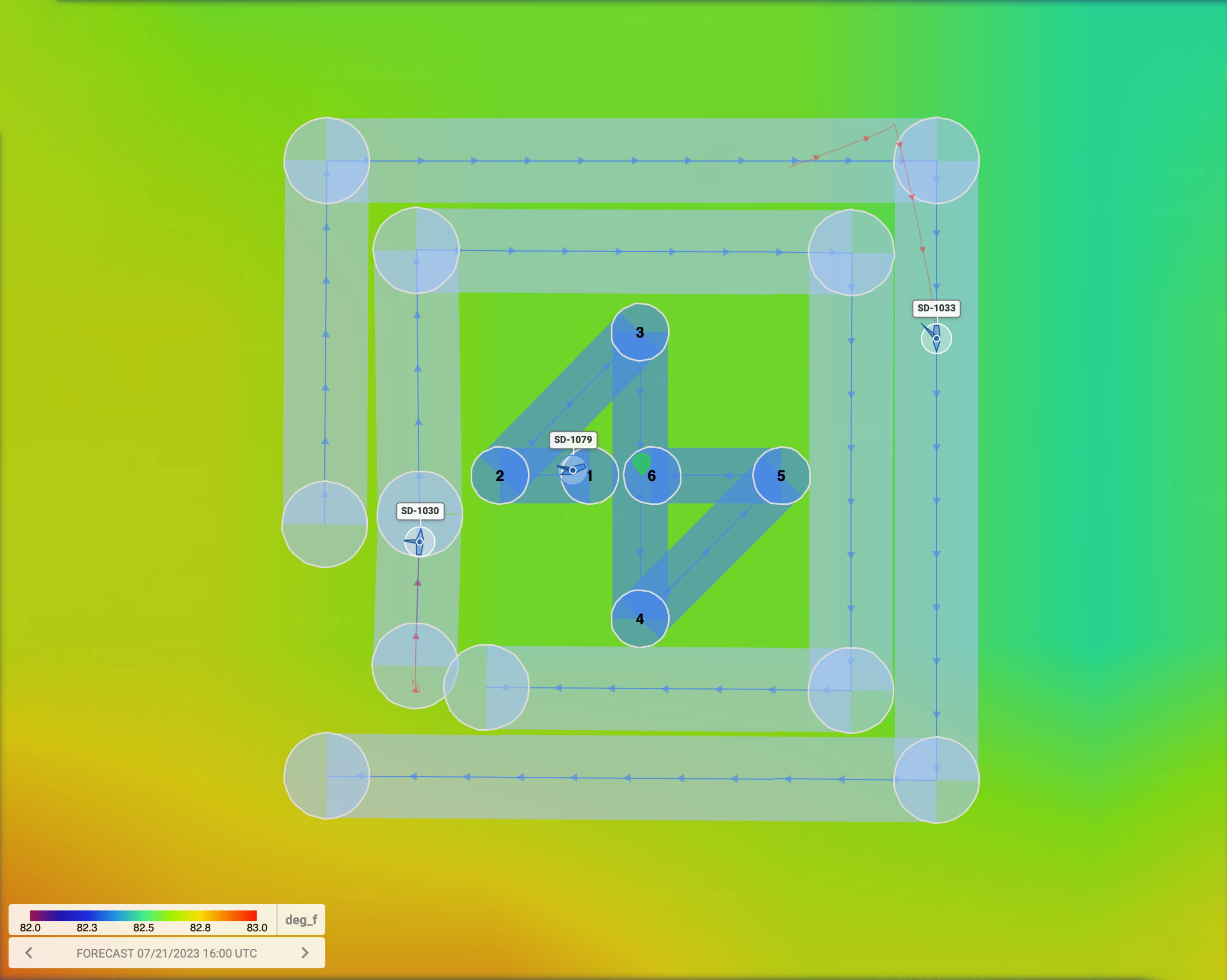
Three saildrones in an adaptive sampling formation to estimate ocean upwelling along the equator at 153.5°W.
Today we bring you a guest post from Dr. Yolande Serra, a co-Principal Investigator involved with the eastern Pacific TPOS Saildrone missions. Dr. Serra is investigating the ability of Saildrone USVs to estimate ocean upwelling along the equator using a variety of adaptive sampling techniques, and we hope you enjoy her update as follows:
As of early morning local time on 17 July 2023 (18:00 UTC), the three saildrones have been circling the equator at 153.5°W. Two drones (each outfitted with an Acoustic Doppler Current Profiler, or ADCP) are in a box pattern, one inside the other, with the outer box 22 km x 22 km and the inner box 16 km x 16 km. The third drone (outfitted with the EK80 Echosounder) is in a "butterfly pattern" of two triangles inside the inner box, with 10 km between the farthest way points and 7.5 km between the closest way points. The ocean current data collected during this period, planned for about 7 days, will be used to estimate ocean "upwelling", or the vertical movement of water in the water column within the overall pattern. Observations of ocean currents from the drones extend from the near surface to approximately 80 m depth. Upwelling in the upper ocean brings colder water from below to the surface and occurs on the equator where winds cause divergence of water at the surface. During El Niño, when the equatorial easterly winds relax, upwelling is weakened and, together with other factors, results in warm surface temperature anomalies at the equator. We hope to learn something about the short time scales of variability in upwelling associated with the overall weakening of this process during the current El Niño.
Thank you Dr. Serra for contributing to the mission blog and explaining some of the important research carried out during the 2023 TPOS mission!
It's Go Time!
July 7, 2023
After completing a 3-day intercomparison against the WHOTS mooring located north of O'ahu, HI, the three Saildrone USVs arrived at the launch site near 18°N, 155°W on June 22, 2023, marking the official beginning of the 2023 TPOS Mission. The drones are demonstrating remarkable transit speeds, having already completed 2-day intercomparisons against the Tropical Atmosphere-Ocean (TAO) moorings located at 8°N and 5°N along 155°W. The drones are now being routed to the east along 5°N before turning south towards the Equator as part of a new adjustment to the mission parameters. Given the current state of El Niño, the eastern edge of the warm pool (EEWP) is quickly approaching the Equator near 155°W, and it is expected that the EEWP will expand between 155°W and 140°W in the coming months. The EEWP refers to the eastern edge of the western Pacific warm pool that is characterized by sea surface temperatures warmer than 28° - 29°C (82°F - 84°F) and is subject to deep convective storms with large quantities of rainfall that freshen the sea surface. During an El Niño phase, the warm pool expands to the east, resulting in above average sea surface temperatures in the central and eastern equatorial Pacific. While the mission goal to study the EEWP has not changed, the study region has shifted to the east of 155°W along the Equator, where the drones will perform adaptive sampling techniques to estimate the rate of ocean upwelling and capture air-sea interactions.
Setting Sail with TPOS 2023
June 5, 2023
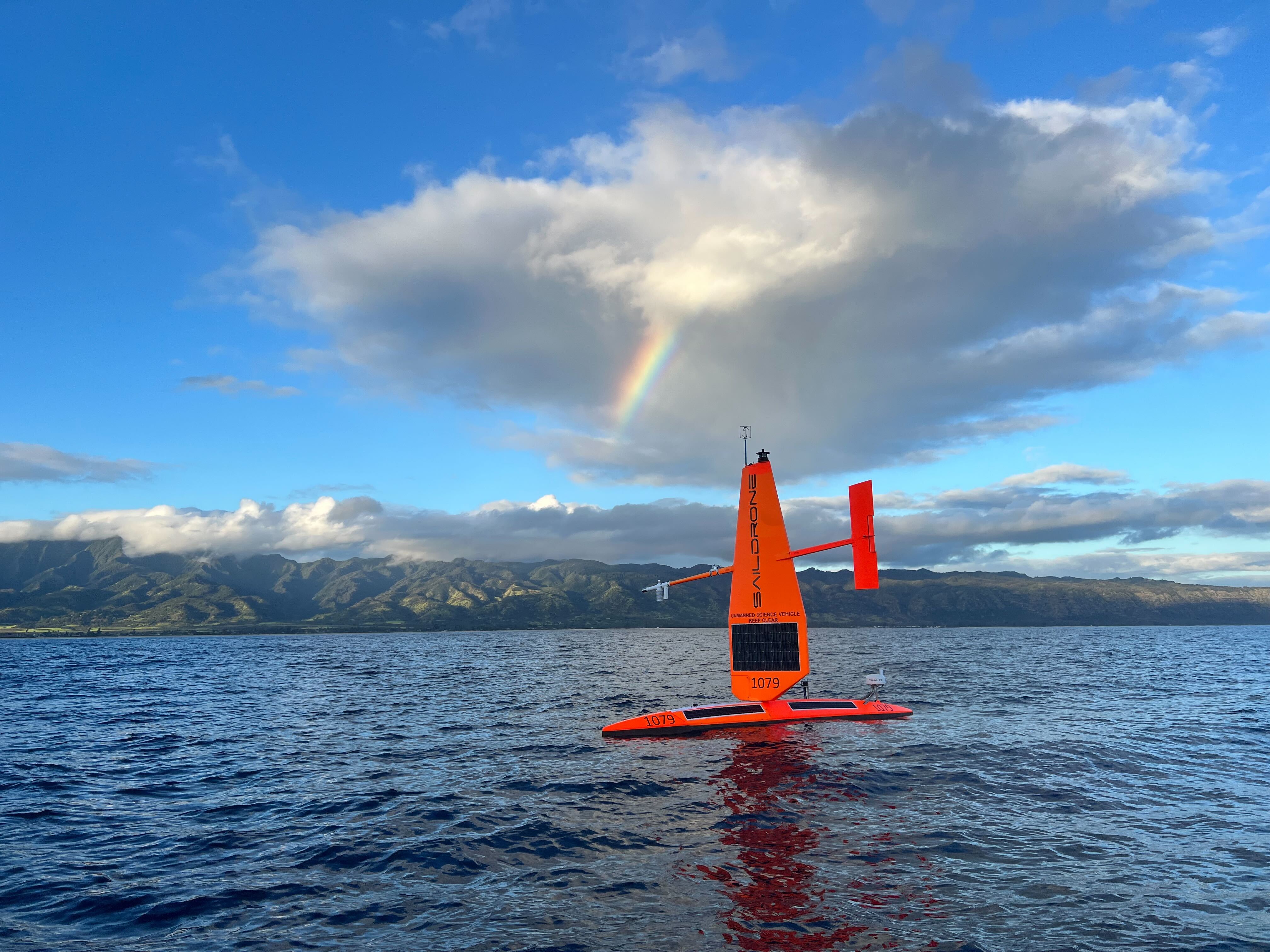
SD1079 deploys in Hawaii, with a rainbow seen in the background. Courtesy Saildrone.
On May 24, 2023, three uncrewed surface vehicles (SD1030, SD1033, SD1079) of the Saildrone Explorer series class departed Hawaii to perform field testing prior to starting their journey to the central tropical Pacific study region. In addition to field testing, the three drones were routed to station ALOHA located just north of O'ahu, HI to perform intercomparisons against the WHOTS mooring maintained by the Woods Hole Oceanographic Institution (WHOI) Upper Ocean Processes Group. Unlike in past missions, one of the drones (SD1079) is outfitted with an EK80 echosounder that monitors biomass of organisms on a variety of trophic levels (or the position an organism occupies in a food web, such as that of a shark vs. minnow vs. phytoplankton). The addition of the EK80 echosounder to the Saildrone will allow us to test the ability of USVs to carry out surveys for the National Marine Fisheries Service (NMFS) and develop a new partnership within the Tropical Pacific Observing System (TPOS).
The TPOS 2023 Mission will officially begin once the three drones arrive at the launch site near 18°N, 155°W, which is expected to occur in the next couple of weeks. This mission is occurring at an exciting time during the El Niño Southern Oscillation (ENSO) cycle, with current ENSO neutral conditions expected to transition to El Niño conditions in the next couple of months. An El Niño state occurs when above-average equatorial sea surface temperatures (SST) are present throughout the central and eastern tropical Pacific, leading to a weakening or even reversal of the Trade Winds. Compared to past missions with strong westward-flowing ocean currents along the Equator, it is possible that the drones will encounter opposite conditions during an El Niño phase, potentially impeding their westward progress. Needless to say, this will be an evolving mission, so stay tuned for more updates!
Fun Aside: Interestingly, the term "El Niño" derives from the name "El Niño de Navidad" given by South American fishermen in the 1600s, who first noticed periods of unusually warm water in the Pacific Ocean around the month of December. While many of us understand the climatic effects of El Niño over land (i.e., wetter and cooler conditions in the southern U.S. vs. warmer and drier conditions in the northern U.S.), there is also a large impact on marine life throughout the tropical Pacific. For example, reduced upwelling (or upward motion) in the eastern Pacific Ocean leads to less nutrient-rich water from below to produce phytoplankton and support fish populations, subsequently impacting the fishing industry and coastal communities that depend on fishing. As we continue our work to research ENSO and understand this closely-coupled air-sea phenomenon, it is our goal to become better prepared to handle changes to Earth's complex climate system.
This blog page is maintained by Samantha Wills.


