Feature Publication Archive
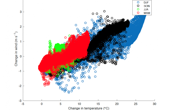
Scatterplot of changes in 10-m wind speed vs lower-atmospheric temperature change over the region north of 50°N for the four seasons: winter (DJF), fall (SON), summer (JJA), and spring (MAM).
Mioduszewski, J., S. Vavrus, and M. Wang (2018): Diminishing Arctic sea ice promotes stronger surface winds. J. Climate, 31(19), 8101–8119, doi:10.1175/JCLI-D-18-0109.1.
Projections of Arctic sea ice through the end of the 21st century indicate the likelihood of a strong reduction in ice area and thickness in all seasons, leading to a substantial thermodynamic influence on the overlying atmosphere. In this study, the authors identified patterns of wind changes in four seasons across the Arctic and their likely causal mechanisms, particularly those associated with sea ice loss.
The authors compared the outputs from the Community Earth System Model Large Ensemble Project for two... more »
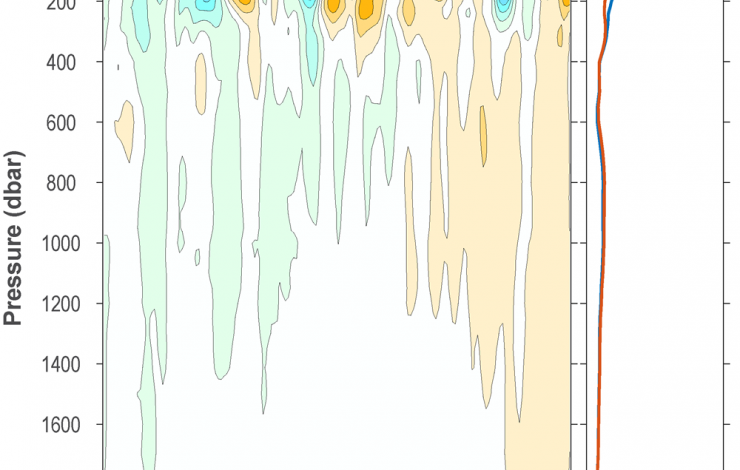
Ocean temperature anomalies. (a) Near-global integrals of ocean temperature anomalies relative to the record-length average seasonal cycle updated from Roemmich and Gilson (2009). (b) Linear trend of temperature anomalies (orange line), and trend with a Niño3.4 regression removed (blue line) following Johnson and Birnbaum (2017).
Johnson, G.C. (2018): Overview. In State of the Climate in 2017, Global Oceans. Bull. Am. Meteorol. Soc., 99(8), S69, doi: 10.1175/2018BAMSStateoftheClimate.1.
Feely, R.A., R. Wanninkhof, B.R. Carter, P. Landschützer, A.J. Sutton, and J.A. Triñanes (2018): Global ocean carbon cycle. In State of the Climate in 2017, Global Oceans. Bull. Am. Meteorol. Soc., 99(8), S96–S100.
Johnson, G.C., J.M. Lyman, T. Boyer, C.M. Domingues, J. Gilson, M. Ishii, R. Killick, D. Monselan, and S. Wijffels (2018): Ocean heat content. In State of the Climate in 2017, Global Oceans. Bull. Am. Meteorol. Soc., 99(8), S72–S77.
Johnson, G.C., J. Reagan, J.M. Lyman, T. Boyer, C. Schmid, and R. Locarnini (2018): Salinity. In State of the Climate in 2017, Global Oceans. Bull. Am. Meteorol. Soc., 99(8), S77–S81.
Overland, J., E. Hanna, I. Hanssen-Bauer, S.-J. Kim, J.E. Walsh, M. Wang, U.S. Bhatt, and R.L. Thoman (2018): Surface air temperature, in State of the Climate in 2017, The Arctic. Bull. Am. Meteorol. Soc., 99(8), S144–S146.
Timmermans, M.-L., C. Ladd, and K. Wood (2018): Sea Surface Temperature, in State of the Climate in 2017, The Arctic. Bull. Am. Meteorol. Soc., 99(8), S146–S147.
NOAA has led, for 28 years, a team of international scientists in issuing annual reports on the state of the climate focusing on the year just passed. The State of the Climate in 2017 report was published as a supplement to Bulletin of the American Meteorological Society in August 2018. Nine Federal, JISAO (Joint Institute for the Study of the Atmosphere and Ocean, University of Washington), and JIMAR (Joint Institute for Marine and Atmospheric Research, University of Hawai’i at Manoa)... more »
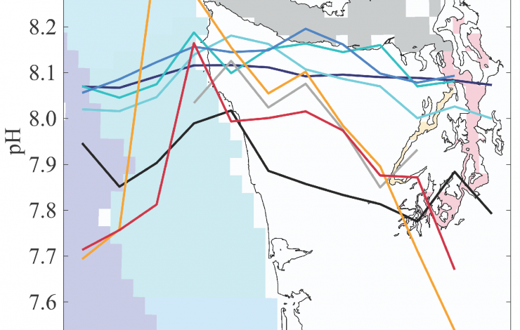
Monthly average pH for Washington's marine waters. Line colors correspond to distinct regions within Washington's marine waters as shown in the base map (blues on coast, grays in straits, and red/orange in Puget Sound)
Fassbender, A.J., S.R. Alin, R.A. Feely, A.J. Sutton, J.A. Newton, C. Krembs, J. Bos, M. Keyzers, A. Devol, W. Ruef, and G. Pelletier (2018): Seasonal carbonate chemistry variability in marine surface waters of the Pacific Northwest. Earth Syst. Sci. Data, 10, 1367–1401, doi:10.5194/essd-10-1367-2018
The northern California Current and Salish Sea ecosystems are hotspots for acidified ocean conditions, which are impacting many marine organisms and intensifying due to on-going ocean acidification. “Ocean acidification” (OA) refers to the global absorption of human-released carbon dioxide by the ocean’s surface, which in turn results in chemical changes including increased acidity (reflected by long-term declines in average pH levels) and reduced concentrations of carbonate ions (relevant to the stability of calcium carbonate shells or skeletons made by organisms such as oysters, clams,... more »
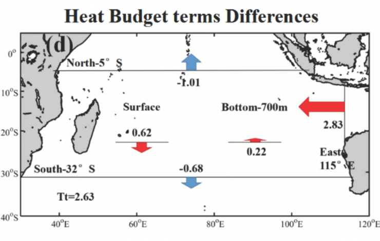
Differences in the heat balance terms in the upper 700 m for the Southern Indian Ocean for two periods: P2 (1998–2015) minus P1 (1992–1998).
Red arrows: an increase in heat transport into the Southern Indian Ocean in P2 relative to P1; blue arrows: a decrease in heat transport into of the Southern Indian Ocean in P2 relative to P1. Units are 10-2 °C per year (approx. 0.02 petawatts of heat). Surface: heat exchanges across the air-sea interface; Bottom-700 m: heat exchanges across 700 m.
Zhang, Y., M. Feng, Y. Du, H.E. Philips, N.L. Bindoff, and M.J. McPhaden (2018): Strengthened Indonesian Throughflow drives decadal warming in the Southern Indian Ocean. Geophys. Res. Lett., 45(12), 6167–6175, doi:10.1029/2018GL078265.
The first decade of the 21st century witnessed a slowdown in the rise of global surface atmospheric temperatures, referred to as the global warming hiatus. During this time, the tropical Pacific Ocean absorbed more heat from the atmosphere than in previous decades, associated with unusually strong trade winds and a cold phase of the Pacific Decadal Oscillation. However, there is no evidence that the tropical Pacific heat content increased during this time. Where did the excess heat go?
Coincidentally, observations indicated that the upper 700 m of the Indian Ocean gained heat at a... more »
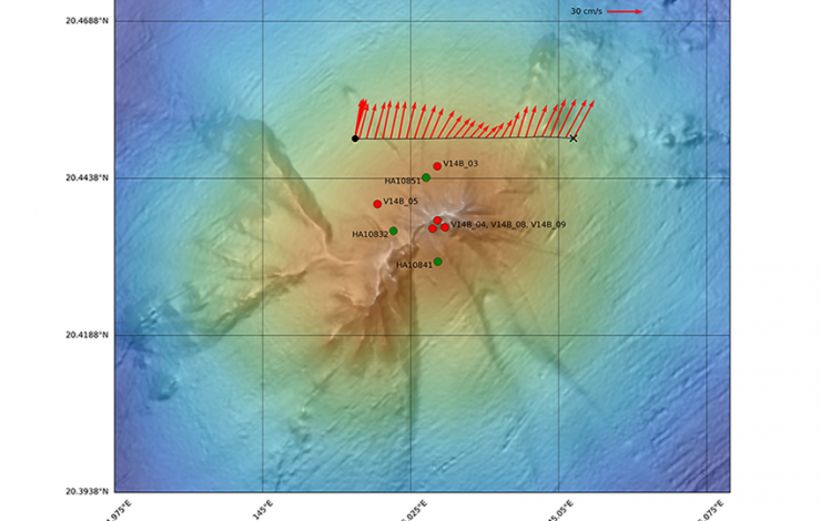
The plume originating from Ahyi was sampled in May (green circles) and December (red circles) of 2014. A CTD tow-yo (black line) was conducted in December 2014 to determine current magnitude and direction (red arrows) within the observed plume depth of 80-200 m.
Buck, N.J., J.A. Resing, E.T. Baker, and J.E. Lupton (2018): Chemical fluxes from a recently erupted shallow submarine volcano on the Mariana Arc. Geochem. Geophys. Geosyst., 19, doi:10.1029/2018GC007470.
The Earth-Ocean Interactions (EOI) group at the NOAA Pacific Marine Environmental Laboratory explores the solid Earth impacts on ocean chemistry and biological productivity. Of particular interest is the role of submarine volcanoes in providing iron, an essential nano-nutrient, to the sun-lit productive layers of the ocean (also known as the surface ocean).
There are many places in the ocean where macronutrients (like those that we put in our garden—for example, nitrate and phosphate) are abundant but a paucity... more »


