PMEL Develops Tsunami Inundation Forecast Models for High Risk Communities in Puget Sound, WA
The main tsunami hazard for Washington State originates from a potential earthquake at the Cascadia Subduction Zone, which is stretched along the U.S. Pacific coasts offshore Washington, Oregon and Northern California. The main impact during such a tsunami event would be the ocean-side communities on the open coast. However, Washington State’s main population centers are located along Puget Sound, a long narrow inlet over 100 miles away from open coast and from potential Cascadia earthquake.
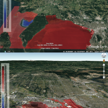
Tsunami test scenario for Bellingham (upper panel) and Tacoma (lower panel) forecast models. Tsunami amplitudes and inundation (red) are shown for the same M9.0 scenario of the Cascadia tsunami 3 hours after tsunami generation. Click on image to see both panels. These figures do not represent an actual forecast or quantitative hazard assessments for Tacoma and Bellingham, these are rather a test simulation of a potential tsunami scenario to verify the robustness of the forecast models.
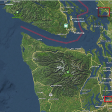
Locations of Bellingham and Tacoma forecast models. Inundation model computational domains are shown as red rectangles.