Feature Publication Archive
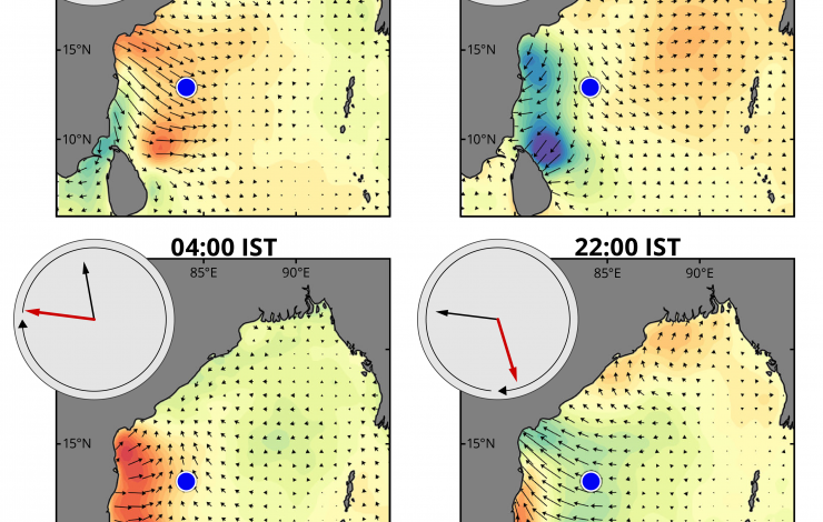
Land breeze wind vectors in the Bay of Bengal at four times of day (India Standard Time) for the average of July and August during the Southwest Monsoon. Red shading indicates winds that are stronger than the daily average and blue shading indicates winds that are weaker than the daily average. Inset shows surface currents (in red) and surface wind stress (in black) relative to the daily average at the location of the instrumented buoy (blue dot) for each of the four times.
McPhaden, M. J. K. Athulya, M. S. Girishkumar, and M. Orlić, 2024: Ekman revisited: Surface currents to the left of the winds in the Northern Hemisphere. Science Advances, 10, eadr0282, https://doi.org/10.1126/sciadv.adr0282.
Ekman's theory of wind-driven ocean currents on a rotating planet is central to our understanding of why surface currents are deflected to the right of the winds in the Northern Hemisphere and to the left of the winds in the Southern Hemisphere. The theory admits solutions for currents deflected in the opposite direction at periods shorter than the local inertial period, but Ekman did not mention these currents and they have only rarely been observed. This paper describes a prominent example of surface flow in the Bay of Bengal directed to the left of clockwise rotating land breeze wind forcing using multiple years of data from a long-term deepwater surface moored buoy. We further refine Ekman's theory so as to better reconcile it with our own and previous measurements, then conclude by discussing the broad implications of this work for understanding wind-forced ocean circulation.
The moored buoy used in this study is maintained by India's National Institute of Ocean Technology, a laboratory within the Ministry of Earth Sciences, one of many buoy systems in the Indian National Ocean Moored Buoy Network for the Northern Indian Ocean, or OMNI. This effort is coordinated... more »
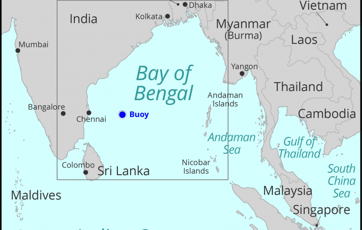
The Bay of Bengal, with the location of the instrumented buoy shown by the blue dot. Credit Sarah Battle, NOAA PMEL
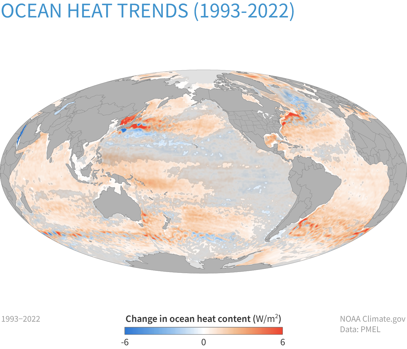
Change in heat content in the upper 2,300 feet (700 meters) of the ocean from 1993-2022. Between 1993–2022, heat content rose by up to 6 Watts per square meter in parts of the ocean (dark orange). Some areas lost heat (blue), but overall, the ocean gained more heat than it lost. The changes in areas covered with the... more »

Cover of the June 2023 issue of the Bulletin of the American Meteorological Society. Synopsis of the article appears in this issue under the title “Ambushed in Paradise: La Niña Brought Deadly Drought to a Tropical Eden”. Cover art by Sarah Battle (NOAA/PMEL).
McPhaden, M.J. and C. Karamperidou, 2022: La Niña Came to Eden. Bulletin of the American Meteorological Society, 103(12), E2862-E2877. https://doi.org/10.1175/BAMS-D-21-0343.1
In July 1929, Dr Friedrich Ritter and Dore Strauch left their spouses and the turmoil of post–World War I Germany for the remote, uninhabited, and rugged volcanic island of Floreana in the Galapagos archipelago. Their dream was to live self-sufficiently in an idyllic tropical setting unspoiled by civilization. Wealthy yachters stopping at Floreana in the early 1930s reported on the couple’s pioneering enterprise to the outside world. The news created a sensation that subsequently attracted other settlers, including a mysterious Viennese faux baroness who quickly sowed discord on the island. Not all the participants in this drama survived though. A prolonged drought gripped the island from 1933 to 1935 leading to food shortages that ultimately claimed the life of Dr. Ritter, a vegetarian who unwittingly ate tainted chicken out of desperation. The bizarre intrigues and struggles to endure on Floreana were chronicled in Dore Strauch’s 1936 memoir "Satan Came to Eden" and a 2013 Hollywood documentary based on it. A story that has not been told is how an extended period of cold La Niña conditions in 1933–35 led to the drought that caused the food shortages. We use an atmospheric... more »
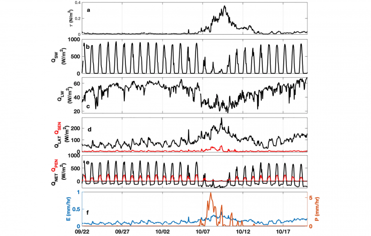
This graph shows the wind stress, heat flux, and evaporation/precipitation measured at the 15°N, 90°E RAMA mooring during the passage of cyclone Titli between September - October, 2018. The wind stress magnitude measured at the mooring increased from nearly zero to about 0.35 N m−2 and wind speed increased by 12 m s−1 in 4 days as the cyclone passed about 200 km to the southwest of the mooring on 9 October 2018 (part a). Click on image to enlarge and see the full graph.
Jarugula, S. L., & McPhaden, M. J. (2022). Ocean mixed layer response to two post-monsoon cyclones in the Bay of Bengal in 2018. Journal of Geophysical Research: Oceans, 127, e2022JC018874 https://doi.org/10.1029/2022JC018874
The Bay of Bengal (BoB) is characterized by a shallow (∼10–20 m deep) fresh layer associated with 40–60 m deep warm near-surface layer during the post-monsoon season (October–November). We use hourly observations from a moored buoy at 15°N, 90°E along with satellite and ocean analysis data sets to understand the evolution of the near-surface layer during the passage of two category-3 cyclonic storms: Cyclone Titli (7–11 October 2018) and cyclone Gaja (10–15 November 2018). The mooring was ∼200 km away to the right of the two cyclone tracks. A 15 day (22 September–7 October) break in the Indian summer monsoon resulted in clear skies, calm winds, and sea surface temperature warming (SST) by 2.8°C before Titli. During Titli, near-surface thermal stratification restricted vertical mixing to 20 m depth and limited SST cooling at the mooring. During passage of cyclone Gaja, fresh Irrawaddy River water associated with a subsurface warm layer was advected to the mooring by mesoscale eddy flow. Cyclone winds could not break through the near-surface density stratification associated with... more »