Tree rings from old growth Douglas-firs on the Oregon Coast show evidence of 1700 tsunami
Core samples taken from a stand of old growth Douglas-fir trees in the South Beach area just south of Newport showed reduced growth following the 9.0 earthquake and subsequent tsunami that struck the Pacific Northwest in 1700.
The physical evidence from the Douglas-fir tree rings confirms modeling that depicts the reach of the January 1700 quake, which was the last major earthquake to hit the Cascadia Subduction Zone, said Robert Dziak, NOAA PMEL Acoustic Program lead.
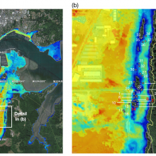
The left panel shows the model of maximum tsunami inundation depth at South Beach for the 1700 CE event and on the right a zoomed-in view of the tsunami inundation depth at Mike Miller State Park. Gray dotted circles show location of trees used in this study on the north side of the stand. Colors on the map show inundation depth from the model, implying 0–10 m of inundation depth at the Mike Miller Park Douglas-fir stand. Green areas are high ground locations that show no inundation. Dziak et al. 2021
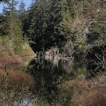
A stand of old growth Douglas-firs near a pond in Mike Miller Park in South Beach, Oregon