

What's New
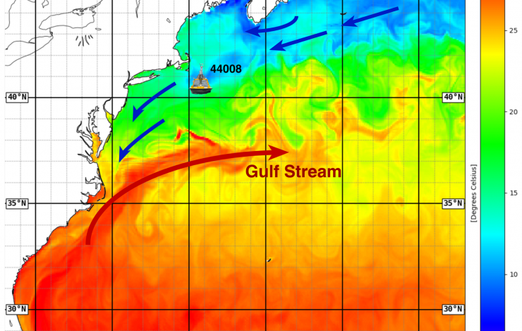
Approximate location of the enhanced NDBC 44008 weather buoy shown overlaid on an analysis of sea surface temperature in degree Celsius for 17 June 2025 from the NOAA Global RTOFS high resolution ocean model. The blue arrows indicate the return surface flow north of the Gulf Stream, with the larger red arrow depicting the Gulf Stream. Image Credit: NOAA Ocean Prediction Center, modified by Y. Serra to show buoy and current arrows.
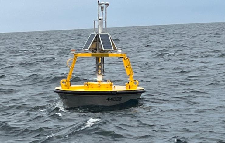
Enhanced weather buoy 44008 deployed on 9 May 2025 at 40.50°N 69.25°W. Photo courtesy of James Elliott, NDBC.
On May 9, 2025, a research-enhanced weather buoy was deployed at 40.50°N 69.25°W for an expected observing period of one year. Working alongside a team of engineers and technicians at the National Data Buoy Center (NDBC), Dr. Yolande Serra's (UW/CICOES) project has enhanced weather buoy 44008 with additional surface and subsurface sensors. The station, located on the New England shelf on the north side of the core Gulf Stream current in 72 meters of water, has standard measurements of wave height and period, sea surface temperature, wind speed and direction, air temperature, humidity, and surface pressure available from all NDBC operational weather buoys. This project's enhancements include a current meter at 3 meter depth, subsurface temperature, salinity, and pressure sensors distributed at depths from 5 to 55 meters, an upward looking acoustic doppler current profiler at 55 meter depth, and upward looking solar and infrared radiometers mounted on the buoy tower.
With the addition of the radiation sensors, the weather buoy now provides all the components of the surface... more
PMEL in the News
A new emerging ocean observing network joins the Global Ocean Observing System (GOOS), marking a key step in expanding coordinated, global ocean surface observations. This fleet of Uncrewed Surface Vehicles, called SUN Fleet, is able to monitor numerous GOOS Essential Ocean Variables and measure...
The Surface UNcrewed Fleet (SUN Fleet) – a new network of ocean robots – could solve longstanding scientific challenges.
Washington's coastal communities face a significant threat from tsunamis, with potential water heights reaching three stories in some areas following an offshore magnitude 9.0 earthquake.
Feature Publication

Uncrewed Surface Vessels, like this Saildrone, offer a cost-effective way to greatly increase ocean observations. Credit: Saildrone.
The global ocean covers 71% of the planet. Across these vast spaces, interactions between the ocean and atmosphere are primary drivers of Earth's weather, climate and marine productivity.
Satellites, instrumented moorings, and infrequent... more