What's New Archive

Deploying CTD (Photo: Sharon Walker)
During a recent multidisciplinary expedition (February 9 - March 5), NOAA PMEL scientist Sharon Walker traveled aboard the New Zealand research vessel Tangaroa to the Brothers submarine volcano. The cruise went from Wellington to Tauranga, NZ, and included scientists and technicians representing various fields from New Zealand, Italy, UK, and U.S.
The expedition’s goal was to image the volcano's magma/melt regions and hydrothermal pathways using 25 seafloor Ocean Bottom Electro-magnetometers (OBEM) for passive and controlled-source electromagnetic (CSEM) measurements. Essential data collected will test hypotheses on processes supporting distinct vent fields and mineral deposit formation. Additional work included repeat magnetic and gravity surveys, hydrothermal plume mapping for output changes, dredging for volcanic history, and multibeam mapping to fill regional gaps.

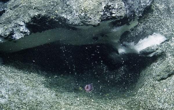
Hydrothermal plumes mapped during CTD tows over Brothers submarine volcano.
The expedition was led by Dr. Cornel de Ronde of Earth Sciences New Zealand**, a long-time collaborator (1998-present) with PMEL Vents and Earth-Ocean Interactions (EOI) programs, exploring submarine volcanoes in the Kermadec-Tonga, Mariana, and Aeolian arcs, NE Lau basin, and other sites.
Other participants included scientists and technicians from University of Southampton (UK) to support the CSEM survey, University of Durham (UK) to support the OBEM instruments and deployments, Università di Genova (Italy) for the magnetic/gravity anomaly survey, and Earth Sciences New Zealand (formerly both GNS Science and NIWA) to support mapping and hydrothermal plume surveys (Sharon Walker led the hydrothermal plume surveys).
** Earth Sciences New Zealand is the result of a recent merger combining the NZ crown institutes of GNS Science and NIWA. Dr. de Ronde is a senior scientist from GNS Science.
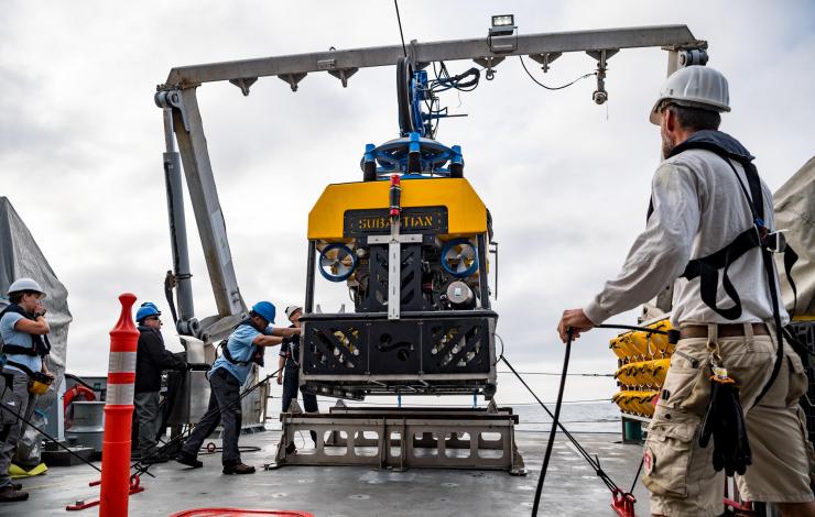
EOI scientist Dr. Tamara Baumberger will be joining an expedition on R/V Falkor, a research vessel operated by the Schmidt Ocean Institute, for an expedition to explore methane seeps on the Cascadia continental margin (off-shore Washington, Oregon, and northern California), June 12-July 3, 2019. While at sea, text, images, and video updates will be posted to the cruise web site.
Live video from dives with the remotely operated vehicle (ROV) SuBastian will also be available from the Schmidt web site.
Methane is a more potent greenhouse gas than carbon dioxide, but exists at far lower concentrations in the atmosphere. Many think of methane as a free-floating gas so it can be a surprise to learn that nearly one-fifth of the Earth’s methane is stored beneath the ocean’s waters in marine sediments in the form of gas hydrate. Gas hydrate is a frozen form of methane and water that naturally occurs in seafloor sediments at the high pressures and low temperatures that persist near the seafloor at water depths greater than 300-600 meters (~985 to 1970 feet). Continued warming of ocean waters could destabilize these gas hydrate deposits, releasing methane into the surrounding sediments, the overlying water column and possibly even the atmosphere. Because methane traps solar heat in the Earth’s atmosphere far more effectively than carbon dioxide, widespread release of this potent greenhouse gas from degrading marine gas hydrate deposits could be a concern if the seafloor methane emissions reach the atmosphere.
The remotely operated vehicle (ROV) SuBastian will be used to collect samples of gas streaming out of the seafloor at seeps located at different distances from the deformation front, which is where tectonic plates under the eastern Pacific Ocean dive beneath the North American plate. This plate boundary is part of the well-known “Ring of Fire” that surrounds the Pacific Ocean and where earthquakes and volcanic activity occur at plate boundaries. Dr. Tamara Baumberger and her colleagues at NOAA’s Pacific Marine Environmental Laboratory will analyze the gas samples to determine the source of methane feeding the seeps and to look for gases (like helium) that can be a fingerprint for sub-surface fluid circulation that involves rocks deep within this plate boundary zone.
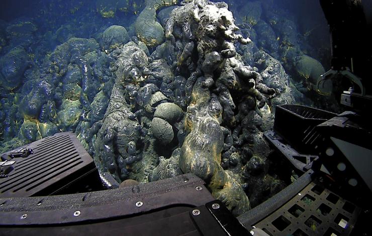
Results of the research documenting a recent volcanic eruption on the Mariana back-arc, 4500 meters deep, (making it the deepest known eruption on Earth) were published this week in a special issue of Frontiers in Earth Science (23 October 2018 | https://doi.org/10.3389/feart.2018.00172). It was first discovered in December of 2015 with cameras aboard an autonomous underwater vehicle, Sentry, by researchers searching for new hydrothermal vents. Bathymetric data also indicated major depth changes in the area collected between surveys in 2013 and 2015, were consistent with an eruption. The new lava flows stretched over an area about 4.5 miles long and ranged in thickness between 130 and 450 feet. Sentry’s 2015 photos revealed the presence of a pristine dark, glassy lava flow on the seafloor with no sediment cover. Images also showed venting of milky hydrothermal vent fluid indicating the lava flow was still warm, and therefore very young. By 2016 when scientists returned to the site in April and December with remotely operated vehicles Deep Discoverer and SuBastian, the observations showed a rapidly declining hydrothermal venting on the lava flows, suggesting the eruption had taken place only months before its discovery the previous year. These expeditions were conducted aboard the NOAA ship Okeanos Explorer and the research vessel, Falkor.
A marine geologist at NOAA’s Pacific Marine Environmental Laboratory and lead of the Earth-Ocean Interactions Program, who is lead author on the study, said “We know that most of the world’s volcanic activity actually takes place in the ocean, but most of it goes undetected and unseen.” In the last 30 years, scientists utilizing improving technology and exploration methods have detected evidence of about 40 undersea eruptions. Before 1990, there were zero. This research is important as undersea volcanoes can help inform us about how terrestrial volcanoes work and how they impact ocean chemistry, which can significantly affect local ecosystems.
The research was funded by the NOAA Office of Ocean Exploration and Research and NOAA’s Pacific Marine Environmental Laboratory, and was supported by the Schmidt Ocean Institute.
NOAA-PMEL-EOI Marianas Research:
https://www.pmel.noaa.gov/eoi/marianas_site.html
Press:
New York Times: A Vault of Glass and the Deepest Volcanic Eruption Ever Detected
OSU Press Release: Researchers discover deepest known underwater volcanic eruption
Earther: The Deepest Volcanic Eruption Ever Documented Left a Gnarly Sight on the Ocean Floor
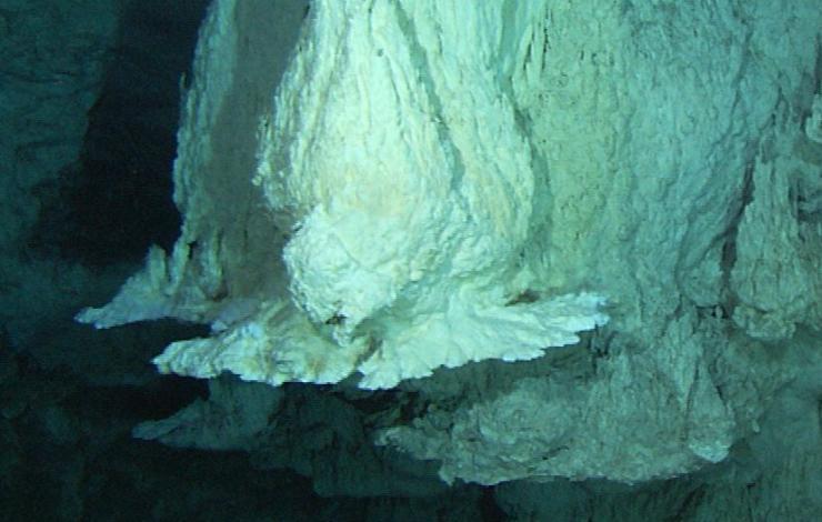
EOI scientists are participating in a deep-sea expedition to the Lost City hydrothermal vent field in September 2018. The Lost City is a beautiful seafloor formation whose unique scientific and cultural value has brought it under consideration for special protection by the UNESCO World Heritage Centre and International Union for Conservation of Nature. The Lost City is also featured in many studies on the origin of life and the search for life in the solar system. This will be the first US expedition dedicated to the Lost City since 2003-2005.
Follow the cruise blog for daily updates at: https://lostcity.biology.utah.

EOI scientists will be going out to Axial Seamount on a sea-going expedition, August 18-27, 2018. Axial is an active submarine volcano located 300 miles west of the Oregon coast. They will be making dives with ROV Jason and the MBARI Mapping AUV from the R/V Kilo Moana.
This expedition will be focused on three main areas:
1) Monitoring the inflation of the volcano caused by magma rising into the volcanic system from below between eruptions
2) The chemistry of hydrothermal vent fluids and how they change with time
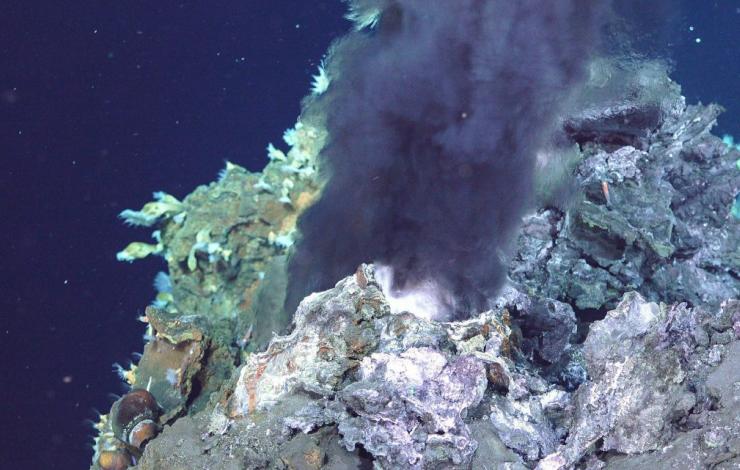
3) Exploration of a new hydrothermal vent field, possibly with active black smoker chimneys, that was discovered recently with high resolution AUV bathymetric mapping.
Follow the cruise blog for daily updates at: http://axial2018.blogspot.com/
EOI scientists aboard E/V Nautilus June 12-29 used multibeam sonar and a remotely operated vehicle to more fully document and characterize the undersea methane sites from Northern California to Washington. Up until a few years ago, only 100 methane “seep sites” had been identified primarily by fisherman using their fish-finders observing the acoustic reflections of the gas bubbles. Beginning in 2016, EOI scientists began a more systematic mapping of the seeps using new sonar technology on the E/V Nautilus, owned and operated by the Ocean Exploration Trust. About 25 percent of the potential methane seep water column area has now been mapped and analyzed. This year, EOI researchers embarked again on the Nautilus to continue surveying additional methane sites by night. During the day a remotely operated vehicle (ROV) collected samples of gas, methane hydrate, seep water, fauna and rocks at these sites. Analyzing these samples in conjunction with a more complete inventory of sites will help scientists understand the origin of the seeping methane and its impact on the ocean environment.
More information about the Cascadia Margin expedition:
https://nautiluslive.org/cruise/na095
More information about the methane research and expedition can be found at:
NOAA PMEL EOI Program Methane Studies:
https://www.pmel.noaa.gov/eoi/pmel-theme/methane-seeps
Oregon State University Press Release:
http://today.oregonstate.edu/news/osu-noaa-researchers-document-widespread-methane-seeps-oregon-coast
EOI Scientists recently completed a 2-part expedition aboard R/V Falkor in the NE Lau Basin in the SW Pacific, one of the most volcanically and tectonically active parts of the planet (November 10 - December 18, 2017). Leg 1 included CTD casts and tows to locate hydrothermal plumes and the AUV Sentry made dives to collect high-resolution bathymetry. Leg 2 returned with ROV SuBastian on board to make dives at a 11 different submarine volcanoes in the area. Findings include detecting a wide range of eruption styles, observing some of the rarest rock types on Earth, exploring the largest known dacite lava flow on our planet, and discovering three new hydrothermal venting sites. Read more about the expedition at Schmidt Ocean Institute’s web site.
SOI provided the ship and support for this expedition. Additional support is provided by NOAA Office of Ocean Exploration.

Black icons are benchmarks where pressure measurements will be made and white dots are hydrothermal vent locations.
The 2017 expedition to Axial Seamount was on R/V Revelle, July 13-23, with ROV Jason and AUV Sentry on board. On this expedition we made measurements to monitor the continued re-inflation of the volcano since its last eruption in 2015 so we can better understand how magma is supplied and stored within the volcano, how it fuels hydrothermal vents and their biological communities, and how we can refine forecasts of future eruptions. We also sampled hydrothermal vents to continue a time-series aimed and understanding the interactions between volcanic events and the hydrothermal and biological systems. A cruise report is in preparation and will be posted here when it is finished.
The expedition website with daily logs from July 12-23 aboard the R/V Revelle with ROV Jason and AUV Sentry is available at:
https://axial2017.blogspot.com

E/V Nautilus expedition NA080 leg 2 begins the evening of May 22 and continues through June 5 mapping the seafloor and water column in search of methane bubble emission sites. This part of the Ocean Exploration Trust (OET) expedition is a continuation of work that was done last summer for PMEL Earth Ocean Interactions (EOI) Program on the Cascadia Margin, offshore Washington, Oregon, and Northern California. 2016 expeditions NA072 and NA078 resulted in the discovery of 905 individual methane bubble streams that were clustered into 317 emission sites. The vast majority of those sites were previously unknown. The purpose of this exploration is to establish a baseline of methane bubble emission sites and methane-derived habitat (carbonate hardground) for the Cascadia margin. A warming ocean could disassociate some of the solid methane hydrate now locked up in the sediments along continental margins at >~ 500 m depth. Methane is a potent greenhouse gas so there is interest in understanding what happens to the methane as it rises through the water column. Does it make it into the atmosphere? Does it contribute to ocean acidification? There is also interest in the extent of the seep habitat and associated hardgrounds from the perspective of essential fisheries habitat. Those are just a few of the questions EOI scientists are hoping to answer with this research. You can follow the expedition here: