2022 Saildrone Atlantic Hurricane Mission

Seven saildrones were deployed in the western Atlantic, Caribbean, and Gulf of Mexico during the 2022 Atlantic hurricane season, following the success of the experimental 2021 mission.
Keep up with the progress of the 2022 mission on the blog.
Objectives
(1) Measure near-surface atmospheric and upper-ocean parameters to calculate energy and momentum fluxes between the atmosphere and ocean outside and within hurricanes.
(2) Synchronize the deployments of saildrones and other uncrewed systems (ocean gliders, airdrones) and conventional assets (moored buoys, airborne atmospheric dropsondes and oceanic profilers) to measure the air-sea transition zone (upper ocean, air-sea interface, and marine atmospheric boundary layer).
(3) Transmit data in real-time to operational weather prediction centers to improve atmosphere-ocean initial conditions in forecast models.
(4) Apply the observations to understand how air-sea interaction affects hurricane intensity and to advance hurricane prediction models.
Deployments
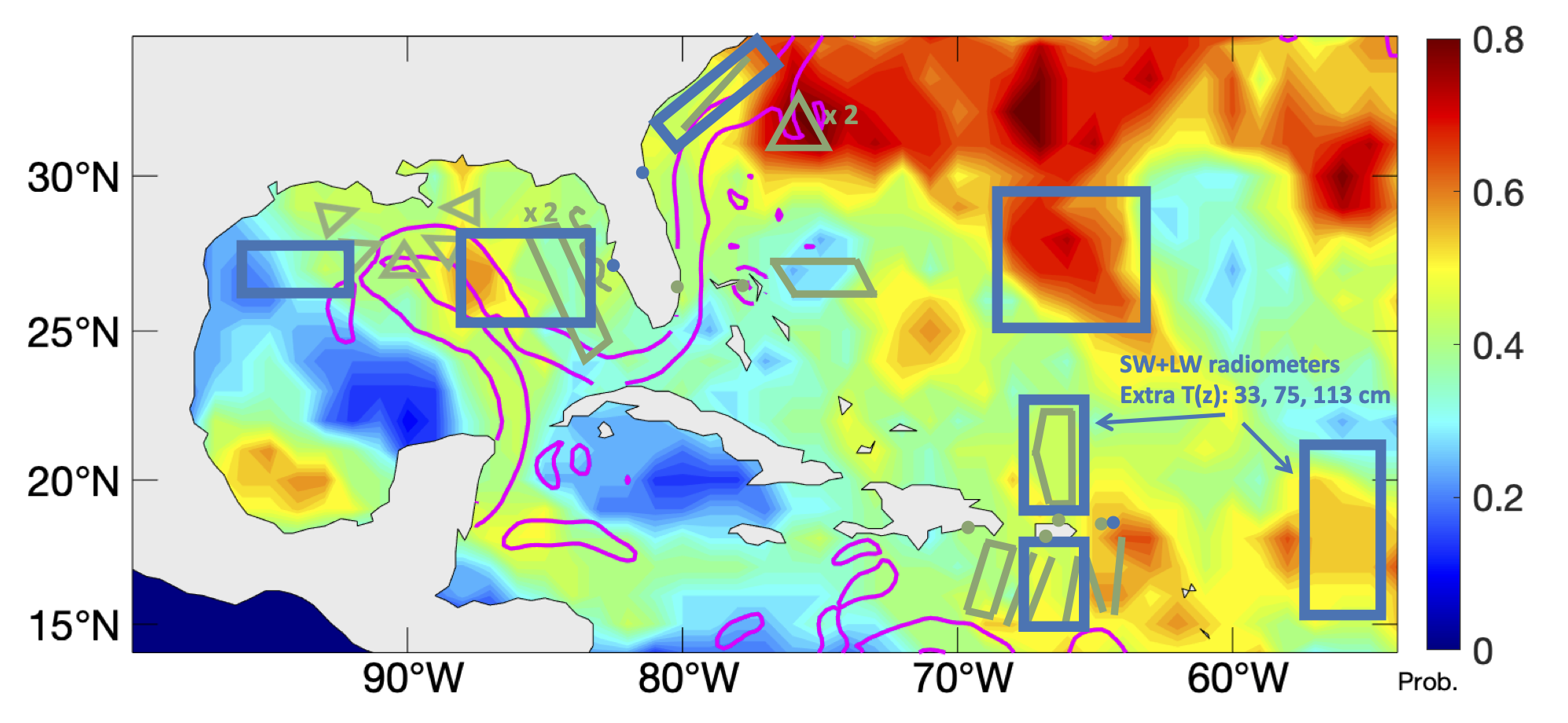
Saildrone observations covered August 1-November 6, 2022 in seven areas (highlighted by blue boxes in the map below) where chances of hurricane occurrence are high. Observations were sent to worldwide weather prediction centers in real time to assist their operational forecasts. Data were released for public use in near real time. This project also involves partnerships with NOAA's Environmental Modeling Center (EMC) of the National Weather Service and the CoastWatch of NOAA's National Environmental Satellite and Data Information Service (NESDIS).
Saildrone IDs in this mission are:
Main Accomplishment
- Two major hurricanes were observed by six different saildrones, twice near their eyewalls. Fiona was observed by four saildrones from when it was first named a tropical storm to when it became a category 4 hurricane (see animation below). Ian was observed as it made landfall on the west coast of Florida and again after it crossed Florida into the Atlantic Ocean.
- Selected observations (air temperature, humidity, pressure, wind direction and speed, ocean temperature and salinity, wave height and period) were submitted in real time to the Global Telecommunication System (GTS) for operational environmental forecasts.
- Observations were used by the National Hurricane Center in their advisories.
- Coordinations were made between saildrones and underwater gliders 10 times with a total of 145 days of collocated measurements.
- Saildrones made comparisons with moored buoys 18 times with a total of 20 days of collocated measurements.
- Seven aircraft-deployed dropsondes were launched near (within 200 km) five saildrones to provide nearly collocated observations of atmospheric profiles in temperature, humidity, and winds.
NOAA Mission Team:
Gregory Foltz, AOML (Co-Lead)
Chidong Zhang, PMEL (Co-Lead)
Andy Chiodi, PMEL/University of Washington
Calvin Mordy, PMEL/University of Washington
Catherine Edwards, Skidaway Institute of Oceanography, University of Georgia
Christian Meinig, PMEL
Dongxiao Zhang, PMEL/University of Washington
Edward (Ned) Cokelet, PMEL
Eugene Burger, PMEL
Francis Bringas, AOML
Gustavo Goni, AOML
Hristina G. Hristova, PMEL/University of Hawaii
Hyun-Sook Kim, AOML
Kathleen E. Bailey, U.S. Integrated Ocean Observing System
Kevin O'Brien, PMEL/University of Washington
Noah Lawrence-Slavas, PMEL
Joaquin Trinanes, AOML/University of Santiago, Spain
Jun Zhang, AOML/University of Miami
Lev Looney, AOML/University of Miami
Nan-Hsun Chi, PMEL
Hauke Schulz, PMEL/University of Washington
With support of
Brian D'Souza, University of Illinois at Urbana-Champaign (NOAA Lapenta Summer Intern)
Colman Bashore, Middlebury College (NOAA Summer Intern)
Shuichi Mori, JAMSTEC
This mission is supported by NOAA's Office of Oceanic and Atmospheric Research (OAR), NOAA's Office of Marine and Aviation Operations (OMAO), Weather Program Office (WPO), and Global Ocean Monitoring and Observing (GOMO) in collaboration with Saildrone, Inc.