Realtime data from the OOI instruments at Axial Seamount
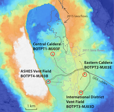
The maps below show the locations of four Bottom Pressure/Tilt (BOTPT) instruments at Axial Seamount, part of the National Science Foundation's (NSF) Ocean Observatories Initiative (OOI) Regional Cabled Array (RCA) seafloor observatory, operated by the University of Washington. Click on the "DATA" links (below right) to see plots of near-real-time data (updated every 15 minutes) from the 4 BOTPT instruments and 4 seafloor CTD instruments. The BOTPT instruments were built by NOAA's Pacific Marine Environmental Lab and Oregon State University. Follow our attempts to use the BOTPT data to forecast the next eruption -> HERE and using the "INFLATION FORECAST" links below. Information on our previous expeditions to Axial Seamount is available -> HERE.
INFLATION & TILT RATES VS. TIME
|
DATA FROM CTD INSTRUMENTS |
 |
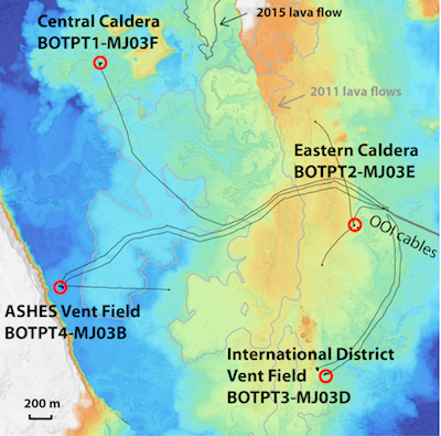 |
| Map of Axial caldera with OOI cables (black lines), recent lava flows (grey outlines), and locations of BOTPT instruments (red circles). | Map of Axial caldera with OOI cables (black lines), recent lava flows (grey outlines), and locations of BOTPT instruments (red circles). |
More information
National Science Foundation | The Ocean Observatories Initiative | Regional Cabled Array Observatory
Required OOI disclaimer: This is provided as pre-commissioned data intended for scientific use, and is subject to the OOI Data Policy. This data has not been through Quality Assurance checks.
Required NSF disclaimer: This material is based upon work supported by the National Science Foundation. Any opinions, findings, and conclusions or recommendations expressed in this material are those of the author(s) and do not necessarily reflect the views of the National Science Foundation.