Realtime El Niño Measurements
A comprehensive list of realtime measurements and data analyses and products related to El Niño / La Niña
In situ and Climate Data
- Tropical Pacific Conditions: Real-time TAO El Nino buoy data
from the NOAA/PMEL TAO buoy network - State of the ocean climate - ENSO indices | Atmosphere | Surface ocean | subsurface ocean | sea ice
from NOAA Ocean Observations Panel for Climage - Global drifting buoys
from NOAA AOML - Argo profiling floats
from NOAA PMEL, the U.S. Argo Data Center, the Argo Information Centre, and the Argo global data centers USGODAE and IFREMER. - Sea level data
from the University of Hawaii Sea Level Center - XBT/XCTD
from Scripps Institution of Oceanography - Realtime Cooperative Agency Profilers (CAP) profiler data (vertical profiles of hourly winds)
from NOAA Earth System Research Laboratory - Realtime SST data
from NOAA National Centers for Environmental Prediction - Realtime climate maps | US Climate plotting | Sea Surface Temperature animations
- from NOAA ESRL
- Regional Climate Data - For many regions of the US and the globe, updated weekly
from the Climate Prediction Center at the National Centers for Environmental Prediction - Monitoring climate information - Degree days, Palmer drought data, snow cover data, etc.
from the National Centers for Environmental Prediction / Climate Prediction Center - Pacific Island Climate Data and Maps
from the National Centers for Environmental Prediction / Climate Prediction Center - Global Climate Data & Maps - Climate, Weather Analyses and Weather Forecasts
from the Climate Prediction Center at the National Centers for Enviornmental Prediction - Monthly atmospheric and sea surface temprature indices (including SOI)
from the National Centers for Environmental Prediction / Climate Prediction Center
Data Products & Analyses
- Upper ocean heat content and ENSO
from NOAA PMEL TAO - NCEP Sea Surface Temperature: Global | Tropical Pacific
from Sea Surface Temperature analyses page at NCEP's Environmental Modeling Center - Recent BMRC/NMC Global SST analyses
from the Ocean Analyses page at the Bureau of Meteorology Research Center in Australia - NCEP Global SST
from University of Wisconsin-Madison's Space Science and Engineering Center - Global Sea Surface Temperature Charts: Temperature, Anomaly & Climatology
from the Navy Coupled Ocean Data Assimilation (NCODA) at the United States Navy Fleet Numerical Meteorology and Oceanography Center - OSCAR Ocean Surface Current Analyses
from satellite data analyses by NOAA's OSCAR project - Weekly El Nino/Southern Oscillation (ENSO) Update
from the National Centers for Environmental Prediction / Climate Prediction Center - Current state of the Tropical Pacific & Comparison of different El Niños & United States Climate Interactive pages by state
from NOAA's Earth system Research Laboratory - NOAA Wave Watch
from NOAA Environmental Modeling Center
Satellite Data
- Sea surface temperature charts for Equatorial Pacific, Global, etc.
from the NOAA/NESDIS/Office of Satellite Data Processing and Distribution - Coral Bleaching Products
from NOAA/NESDIS/Office of Satellite Data Processing and Distribution - Near-real time sea level / altimeter data products
from NOAA/NESDIS Laboratory for Satellite Altimetry - Near real-time satellite altimetry data
from Colorado Center For Astrodynamics Research - Sea Surface Temperature Watch on the US West Coast
from NOAA Coast Watch
Other Buoy Data
- Equatorial Pacific El Nino (TAO) buoys (NOAA PMEL)
- Interactive marine observations from the National Data Buoy Center (NDBC)
- Tsunami Warning Buoy data (NDBC)
- U.S. Marine Environmental Buoy database from the National Ocean Data Center (NODC)
- Moored, C-MAN and Drifting buoy data from the National Data Buoy Center (NDBC)
- Tides and Currents (NOAA NOS)
- Tides Online (NOAA NOS)
- Global drifting buoys (NOAA AOML)
- Argo profiling floats (NOAA PMEL)
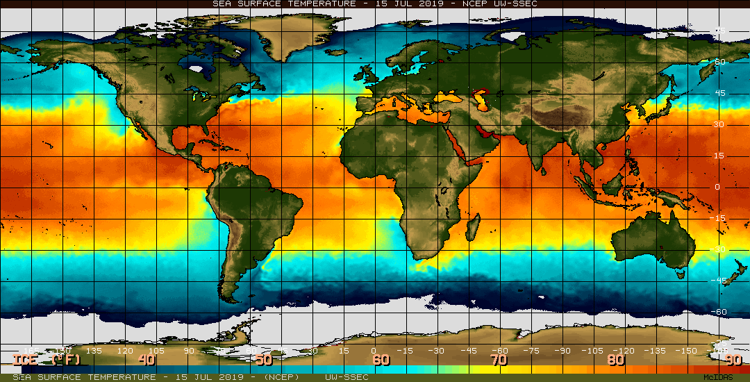
Graphic shows raltime global SST from Space Science and Engineering Center at the University of Wisconsin-Madison.


