Related Stories


La Parguera
La Parguera Mooring (17.95°N, 67.05°W).
La Parguera is located on the southwestern coast of Puerto Rico in the municipality of Lajas. The La Parguera Natural Reserve includes all the coastline of the municipality of Lajas extending 1 km towards land from the shore and 9 nautical miles offshore. Marine and coastal ecosystem including: mangroves, seagrass, reefs, bays and salt marshes.
A MAPCO2TM system was deployed within the La Parguera Natural Reserve on the southwestern coast of Puerto Rico on January 16, 2009 to complement the Integrated Coral Observing Network (ICON) measurements at this location. The goal is to establish as a test bed for monitoring ocean acidification in sensitive coral reef environments through a joint effort between PMEL, AOML and NOAA's Coral Health and Monitoring Program. Local support for the mooring was initially provided by the Caribbean Coral Reef Institute; subsequently by CariCOOS (the NOAA IOOS Caribbean Coastal Ocean Observing System) and throughout the deployment by the University of Puerto Rico, Department of Marine Sciences. Deployment and maintenance of the buoy would have been difficult without this support. The climate and ecosystem monitoring at this location is supported by NOAA’s Coral Reef Conservation Program and Ocean Acidification Program.
On December 2, 2011, a surface seawater pH sensor was added to the La Parguera mooring. By measuring pH in addition to pCO2, we are able to more accurately and precisely study the changes associated with ocean acidification. All seawater pH observations are shown in the second figure below.
Visit the La Parguera blogspot to learn more about the deployment and maintenance of the buoy at this location.
Finalized Data: National Centers for Environmental Information NCEI.
Plots of surface water and atmospheric CO2 and surface water pH (click+drag to zoom):
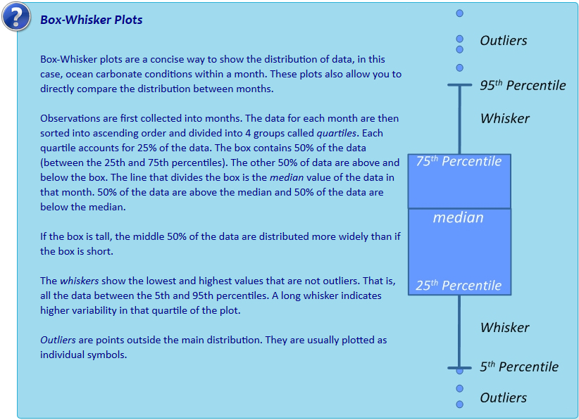
Monthly climatology of surface seawater aragonite saturation state (Ω) and pH:
Interactive box plots below are observations binned by month as described in Sutton et al., 2016. Pie charts represent % of observations within each month that fall below the adjustable line. This adjustable line is meant to provide a tool for assessing potential biological thresholds. For example, setting the line to Ωaragonite of ~2.0 would assess monthly exposure of Pacific oyster larvae to sub-lethal chronic effects in regions where these larvae occur naturally or in hatcheries (see studies here and here).