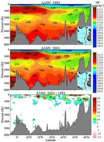
A16N
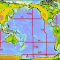
The A16N cruise took place from June 4 to August 11, 2003 aboard the NOAA Ship RONALD H. BROWN under auspices of the National Oceanic and Atmospheric Administration (NOAA). The first hydrographic leg (June 19-July 10) was from Reykjavik to Funchal, Madeira along the 20°W meridian and the second leg (July 15-August 11) continued operations from Funchal to Natal, Brazil on a track southward and ending at 6°S, 25°W. The research was the first in a decadal series of repeat hydrography sections jointly funded by NOAA-OGP and NSF-OCE as part of the CLIVAR/CO2/hydrography/tracer program. Samples were taken from up to 34 depths at 150 stations.
Carbon Data
CTD and other hydrographic data
WOCE section designation: A16N_2003A
Chief Scientists: John Bullister and Nicolas Gruber
Dates: 2003 JUN 04 - 2003 AUG 11
Ship: R/V RONALD H. BROWN
Ports of call: Reykjavik, Iceland to Natal, Brazil
Stations 150
Geographic boundaries: 63° 17.58' N to 6° 0.64' S by 29° 00.00' W to 19° 59.99' W


