

|
|
|
| Home | Daily Log | the Research | Images and Video | Maps | Data | Q&A | Links |

Bering Sea Ice Expedition Daily Log |
||||||||||||||||||||||||||||||||||||||||||||||||||||||||||||||||||||||||||||||||||||||||||||||||||||||||||||||||||||||||||||||||||||||||||||||
This morning we were awakened by the rumbling noise of the Healy docking. We
finished packing,cleaned
our state rooms, said our farewells to the crew of the Healy and to the scientists staying onboard for the next expedition. Then we
made our way to the airport. Once we get home, we will start analyzing the megabytes and megabytes of data we have collected
in the last 33 days at sea. This includes organizing all of our digital photos. We had many avid photographers equipped with a
vast array of photographic equipment. As a result, we stored over 7000 digital photographs on the Healy's public computer
drive. Link here to see some of the most spectacular photos from this cruise. We are rapidly approaching the end of the cruise, as we continue to sail southwest towards deep water off the continental shelf. During this transect, we have crossed a marked front over the shelf-break (200 m depth), characterized by an increase in near-surface water temperature (from 2.0-2.4 to 3.4-3.4 degrees C) and salinity (from 31.2-31.4 to 31.8-32.0 p.s.u.).
Even though the cooler and fresher water from the sea ice melt on the shelf was replaced by warmer water offshore, we did not encounter the patch of Walleye Pollock larvae we had been hoping for. The series of seven CTD/net tow stations along this onshore-offshore line yielded only several eggs and one larva (with a size of 4.41 mm; see photograph at right from a different cruise). This result suggests that the fish had not spawned in this area yet. Nevertheless, the acoustics data collected during the cruise will give NOAA researchers information on the distribution and abundance of adult fish within the study area. Together with the CTD data, the acoustics information will help fishery managers determine whether the adult fish may have shifted their distributions during the spring of 2007, possibly in response to the large extent of cold water on the shelf.
Walleye Pollock are schooling fish, occurring between 100-300 m depth. The adult fish generally move inshore during
summer and offshore in winter, occupying greater depths during the cold-water months. Spawning occurs at different
seasons depending upon the geographic location; in Alaska it happens between March and May. Females spawn in several
batches over a few weeks, producing up to 2 million eggs each. The eggs hatch in 1-3 weeks at the depth of spawning
(usually 100-250 m), and the larvae develop in shallow water (< 30m). Young-of-the-year juveniles feed on plankton
near the surface at night and descend deeper in the water column during the day. To learn more about the ecology and
the fishery for Walleye Pollock, visit the NOAA/AFSC Walleye Pollock Research page. We have been sailing towards the southwest, running an 180 nautical mile (335 kilometer) across-shelf
transect, from the inner shelf (40 m depth) to the slope (2000 m depth). We are going to stop every 30 nautical miles for a station,
where we will complete a CTD cast (CTD cast movie)and a bongo net tow. Like the percussion instrument of the same name, these nets consist of two
separate circular frames and nets, which allow researchers to obtain two distinct samples (bongo net deployment movie).
temperature and salinity in the water column, as the net
makes its way through the water column. These profiles provide information on
the physical structure of the water column where the plankton were collected. We have been sailing eastward toward Bristol Bay, through dense fog and snow fall. Even though the visibility is very low (200-300 meters), the flat seas and gentle swell make for pretty good conditions for whale detection. However, we have only seen a group of harbor porpoise since we left the ice. Our eyes are peeled for cetaceans, especially the highly-endangered northern right whales, as well as for short-tailed shearwaters. An estimated 6-20 million of these far-ranging seabirds migrate each year from their breeding grounds in Tasmania and South Australia to the Bering Sea, where they molt
their
feathers and spend the austral winter. Large flocks of shearwaters forage on euphausiids and forage fish, often in
association with humpback whales. We have not seen any yet, but we hope to encounter some shearwaters and whales farther
west, when we approach the shelf-break on our way back to Dutch Harbor.
But not all of the science is done onboard the Healy. The acoustic/seabird surveys will continue until we run the final
CN (Cape Newenham) line on Thursday/Friday. In fact, one study has not even begun yet. Fisheries
scientists from the Alaska Fisheries Science Center (NOAA/AFSC) in Seattle, will sample the CN line with CTDs and net tows in search of
pollock and crab larvae. In addition to sampling the water column with standardized oblique net tows to obtain a quantifiable
metrics of larval abundance in the water column, the scientists are planning a series of adaptive tows to obtain specimens for
studies of natural history and population genetics. The objective of this research is to understand what oceanographic
conditions enhance the survivorship of these larvae, and eventually their recruitment to the population in the southeastern
Bering Sea shelf. In particular, researchers are focusing on the influence of water temperature on larval conditions and
survivorship, and plan to investigate whether larvae in colder and warmer waters have genetic differences that make
them better suited for living in these different conditions. Came back tomorrow to find out more about pollock larvae and
other cruise results.
Today is Tuesday once more, and the beginning of our fifth and final week onboard the Healy. Today we completed the
200th station of the cruise, well beyond the 187 we originally anticipated, and the count will go on all the way back to
Dutch Harbor.
the afternoon, three final helicopter seal surveys took place. In the meantime, the Healy
encountered scattered groups of walrus (pairs and trios) swimming in open water. These encounters culminated with the sighting
of a large group (approximately 50 animals) resting on the ice. We waved farewell to the walrus and started sailing to the
south and west, heading towards the Pribilof Islands. ** USCGC Healy: Monday, May 7, 2007 (see images for this day) Today we have sailed through alternating areas of young ice (grayish, thin and frail) and thicker
jumbled up pack, as we make our way eastwards towards
Nunivak Island. During our transit, we have encountered thousands of murres
aligned in strings and flying high off the water; they cross our track heading
north and east, possibly returning to their breeding colonies in St. Matthew
and St. Lawrence Islands.
In the evening, we continued making our way eastwards, sampling hydrographic
stations every 30 nautical miles (54 kilometers). Even though some of the
research programs like the mud multi-corer have completed their work, other
groups onboard the Healy will continue sampling until we reach Dutch Harbor.
In particular, we anticipate completing a series of CTD and net tow stations in
Bristol Bay, to compare the current conditions with those we encountered at the
beginning of the cruise. Sunday is a great day for a BBQ - even in the middle of the Bering Sea. We rolled the helicopter out
onto the helo pad and set up a lunch-time feast in
the hanger. Despite the fog and the chilly air temperatures, the grilled
goodies (hot dogs, hamburgers, veggie burgers, chicken patties) and assorted
salads got us in a spring-time mood.
We spent most of the day sailing southwards along the 70-m isobath, making our
way through heavy ice, jumbled up into high piles, and a heavy snow fall. It
was a far cry from the spring-time conditions ideal for seabird/seal
observations (and BBQs). In fact, the fog was so thick that the helicopter
flights were cancelled for the day. Nevertheless, the seal and bird observers
continued their watches from the bridge. Most of the birds we encountered were
northern fulmars flying high off the ice, possibly individuals prospecting their
colonies on St. Matthew and Hall Islands.
last two weeks. This satellite, capable of mapping sea ice
concentrations through clouds and fog, shows that the sea ice has disappeared
from large areas of the shelf, creating two large open water gaps south of
Saint Matthew Island (SM) and north of Nunivak Island (NI). When we consider
this larger-scale picture, we realize that we have been sailing through the
last pocket of dense sea ice (80%-90% cover) left in the southeastern Bering
Sea shelf this year. You can see the ship track to the SE of Saint Matthew Island (SM)
on the "late" panel to the right. Once more, the satellites overhead give
us a very different perspective than the view from the bridge of the Healy. Cinco de Mayo on the Healy. To give the cooks a rest, the crew of the Healy takes turns preparing dinner every Saturday night. Today is the turn of the scientific party, and we are making a Mexican
feast with enchiladas,
chili, quesadillas, churros and flan. In addition to cooking, we did get some "ciencia" done.
At the end of the Nunivak line (NI), David Shull and Allan Duval deployed the multi-corer for the final time this cruise. They
have performed over 25 drops and have retrieved approximately 4000 pounds of mud from the Bering Sea shelf and slope.
This is equivalent to the weight of a small walrus, or for those not accustomed to this unit of mass, about the weight
of a VW bug. Check out some of the organisms that Jerry McCormick-Ray has found in the mud, including worms, echinoderms,
mollusks and foraminifera (note: the organisms are not all shown at the same scale in the photos).
isobath line west of
St. Matthew Island. During this transit, we revisited a series of CTD/net tow stations we sampled about 10
days ago. Since our first visit, the ice has retreated and the near-surface water temperatures (8 m deep) had warmed
substantially (by 1 to 2 degrees C). Check out the map comparing the near-surface water temperatures in the early and
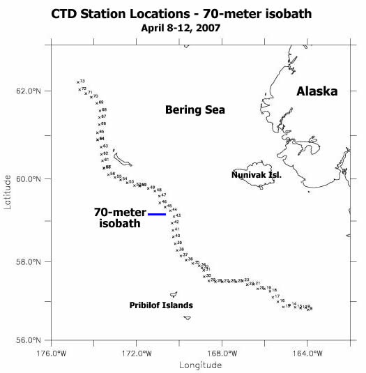
the late time periods of the cruise. The Healy is heading due west towards the shelf-break along the Nunivak Island (NI) line. Tonight, we will take a right-hand turn and start heading northeast towards the northern end of the 70-m isobath transect. We occupied this line earlier in the cruise. This 70-meter isobath line (70-m map) bisects the middle shelf from south to north (Bristol Bay to St. Lawrence Island) and connects the four oceanographic moorings. A second transect along this line will allow us to investigate how the physical and biological conditions have changed during the last two weeks. As we move into spring and the sea ice retreats, we anticipate that the belt of high chlorophyll concentrations will migrate northwards with the ice-edge bloom. We also expect to find the tell-tale signs that the bloom has come and gone farther south via depleted nutrients (nitrate and silicate) near the surface, high chlorophyll concentrations at depth (from the sinking phytoplankton), and higher levels of recycled nutrients (ammonium) in the water column.
In addition to the progressive northward shift of the ice edge, we have observed
from the remote sensing imagery the "rotting out" of the ice and the formation of large open water areas. As we now return north, it is really
apparent that the ice-covered shelf is opening up in front of our eyes. What
once was ice pack with scattered open water leads, now resembles a layer of
swiss cheese with popcorn sprinkled over the top. ** USCGC Healy: Thursday, May 3, 2007 (see images for this day) The day started with a PolarTREC live event in the science library. The two teachers onboard, Maggie and Robyn, use the iridium phone connection in a conference call to get in touch with teachers and school children across the country and abroad. Today's guests were the Healy's
Captain Lindstrom and our chief scientist (Ray Sambrotto). We have held three of these events thus far,
and have scheduled one additional event on the last day of the cruise (May 11th). Together with the blogs available
online, these live events allow Maggie and Robyn to bring our work and experiences into classrooms, increasing the
educational and outreach impacts of this research.
experienced any weather delays, which often happens during research cruises. With
nine days left in the cruise, our top priorities are to take more ice core samples in the area close to Saint
Lawrence Island, re-sample the stations along the 70-m isobath transect, and revisit some of the stations we sampled
in the early part of the cruise in Bristol Bay as we head south.
shallow water, where we will eventually rejoin the Nunivak Island (NI) line. Today we traversed the continental slope and the shelf break in the area of Zhemchug Canyon, and traveled northwards towards the ice-covered region of the shelf. Large numbers (hundreds) of gulls aggregated around the Healy during the deep stations. They seemed disappointed when the CTD or the multi-core emerged from the water. Such a long wait deserves, well, a fish...or two. The
researchers also wait long hours for the samples to come up from depth. Once they are onboard, a frenzy of activity
begins.
In addition to these changes in the type and amount of sea ice, we traveled along the shelf break (at 200-m depth contour). We encountered
the highest bird densities along this steep bathymetric gradient, with murres and gulls concentrated along a fairly narrow (5-10 km)
band. We also encountered a frontal area, separating different water masses, immediately onshore of Zhemchug canyon. We saw some
bull kelp and two pieces of marine debris (a piece of plastic and a float), which suggest that this was an area where bouyant material
was concentrated and retained by surface currents.
During the three weeks we have been on the Healy, we have completed 154 stations and consumed about 210 gallons of milk. Both the excitement of scientific discoveries, and our friends at the "Java shack" keep us going strong. Caffeine (via coffee, tea and chocolate) has proven critical to keep the
science efforts underway. The weather, which has been superb for the last few days,
has allowed us to make great progress and to cover lots of ground. The last
couple of days we have experienced high atmospheric pressure (1009 millibars)
and low wind speeds (below 10 knots). The sunshine enhances the contrast
between the ice cakes and the dark water, turning the sea into a black and
white checkerboard.
including oceanic seabirds (e.g., storm-petrels) and large whales (e.g., tall
and skinny blows sighted off in the horizon, likely from fin whales). Later on
in the summer, we would expect mottled petrels from New Zealand and sperm whales
Today we transited towards the southwest, heading along the outbound leg of the "N" pattern in search for ice edge phytoplankton
blooms. We sailed through the broken pack and an area of lighter sea ice cover (20-40% of the sea surface) littered with
ribbon and spotted seals resting on ice cakes. Even the scientists are coming out on deck to enjoy the Sun and the (relatively)
warm air (go to today's photos to see a variety of basking mammals).
As part of our attempt to identify oceanographically and ecologically interesting areas to sample, we have relied on satellite
imagery to assess how fast the sea ice is retreating northward in the Bering Sea. This image illustrates the sea ice melt back we have
witnessed during the last two weeks, by comparing sea ice extent during an early period (April 15-17) and a later period
(April 28-30). Remember how to interpret these images: areas covered by sea ice appear "rough", while open water areas appear "smooth". Notice the large area of open water northwest of St. Lawrence Island and off Russia, which is apparent in the second
mage but is not visible in the first picture. The Healy has started a series of 25 CTD/net stations along three lines arranged in a zipper-like pattern (like the mirror image of a capital "N") zig-zagging across the shelf. The onshore end of the
lines is anchored on the
ice-covered section of the shelf (depth < 70 m) and the offshore end is over the slope (depth > 2000 m).
By repeatedly crossing the transition between the ice pack and the open water, we will be able to compare
the hydrography (water properties), the productivity (in the water column and the mud) and the animal
distributions (zooplankton, fish, seals, birds) across different ice domains. Last year, this marginal ice
zone proved to be an area of seabird (murres) and whale (rorquals) concentrations. So far, we have only
encountered two minke whales in the area.
As we approached the end of the first line, southwest of Nunivak Island, we sighted large pieces of sea ice stained with dark bands, unlike the more orange-looking patches and bands of sea ice algae we had seen earlier in the cruise. Carleton Ray confirmed that these dark bands were sediments entrained in the sea ice when it froze. The presence of these terrigenous (or land) signatures are evidence that some of this "fast ice" formed on the shore and drifted offshore.
During our northward transit, the physical oceanographers onboard (Carol Ladd,
Nancy Kachel and Dylan Righi) deployed an Argos drifter. This oceanographic
instrument consists of two parts: a
transmitter encased in a float, tethered to a long tubular drogue which sinks
to depth (in our case 40 meters). The drogue portion is referred to as "holey sock". These drifters provide oceanographers data on the movements of the
near-surface part of the water column, which are then used to infer
advection (lateral movement) of water masses and weakly-swimming organisms,
like fish and crab larvae. [movie of drifter launch, 10MB, Quicktime] Today is a major turn-over day at the Healy: the end of the fist leg of the cruise and the start of the second. Several scientists are leaving the ship and being replaced by a new batch, and the personnel transfer is taking place in St. Paul. Scientists, luggage and equipment will be shuttled from the Healy to the local airport via helicopter or small boat, depending on the weather conditions. To ensure
these personnel exchanges go smoothly, it is critical
that departing and arriving scientists have some time to discuss any unexpected
issues or problems that may have arisen during the cruise. Because lunch
provides a great opportunity for these discussions, the Healy's mess deck is
filled to the brim and buzzing with activity.
heading across the shelf and
towards the ice-covered water to the north of us. After the large-scale survey
of the shelf completed during the first leg of the cruise, the second leg will
focus on sampling specific features of interest in more detail. Re-sampling
the area of high chlorophyll concentrations we encountered over the shelf-break
west of St. Matthew island, revisiting the stations in Bristol Bay, and working
along the edge of the sea ice are top priorities. As we enter this "adaptive
sampling" phase of the cruise, real-time information on sea ice conditions
from satellites and helicopter flights will become increasingly important to
locate and track interesting features for sampling. Friday April 27th began with a boat brief. The Healy was stationed off Zapadni Bay, in the south end of St. George Island and we had a ten o'clock appointment on the beach. Nine scientists and two Coast Guard representatives (Stephen Elliott and David Forcucci) suited up with immersion suits and helmets, and boarded two inflatable small boats on the Healy's main deck. After being lowered
approximately 45 feet one at a time, we began cruising towards the snow-covered shore. Flocks of crested auklets, small white and black diving seabirds, lifted off the water in front of the boat as cormorants sped by. Our guests met us at the dock with a school bus. We peeled out immersion suits off and rode the bus into town, passing by the green Russian Orthodox Church, the seal plant, and the kittiwake cliffs. There are no trees anywhere in sight. Despite the bright sun in the sky, it is still winter in St. George: the school's outdoor basketball courts are covered in snow and there are no puffins around.
We are greeted by Carol, Carl, Miriam and Lori - the teachers at the St.
George School - and nineteen curious kids. "People bingo" broke the ice
and gave us a chance to get to learn some important details about each other:
Carleton has hugged a walrus before, Lee has gone whaling before, Maggie does
not like chocolate, Ned has drilled a whole in the ice before, David is wearing
black socks. In St. George, we did not need the Healy to break the ice, just
some smiles. After the ice-breaker, we split up into three groups. The middle
school and elementary school ran a course of activities: they learned about
whaling in Point Hope with Lee, tried drawing a humpback whale, made an
albatross flier, put on an immersion suit in record time, learned about food
webs, and tried some of the goodies Maggie brought from Hawaii. In the meantime,
Robyn Staup and David Shull gave the high school kids a virtual tour of the
Healy and chatted about what being a scientist is all about. Other scientists
went with Rodney on a guided tour of the seal plant, where the blubber and the
pelts from harvested fur seals are processed.
Cokelet (from NOAA's Pacific Marine Environmental Lab) gave a presentation - open to the community at large - about the Bering
Ecosystem Study (BEST) and the objectives and results of this cruise. After a
lively question and answer session, it was time to head back to the dock. The
two inflatable boats (Healy 2 and Healy 3) picked us up at 3 pm. We brought
along four high school students and teachers back with us to the Healy for a
tour and dinner together. The day ended with Captain Lindstrom presenting our
visitors from St. George with a plaque to commemorate their visit. It has been
just a few intense hours in St. George, but we have learned a lot and had a blast. Albatross!!
fulmars and murres, we sighted a Laysan albatross
(Phoebastria immutabilis) soaring effortlessly over the waves. This large
tubenose bird (order Procellariiformes), with a weight of approximately 3
kilograms (6.6 pounds) and a wing-span of 1.8 meters (6 feet), breeds in Hawaii
and off Baja California and ranges across the entire North Pacific and into the
Bering Sea. Laysan albatross chicks are born in late January/early February
and fledge by late June. Their parents commute from Hawaii to the waters of
the North Pacific Transition Domain and the Aleutians during round-trips of up
to 28 days. Even though we have no way to tell with certainty the status (breeding/ non-breeding) or the provenance (central Pacific or Mexican breeding colonies)
of this albatross, we fancy this bird heading back to the Northwest
Hawaiian Islands, where a hungry chick awaits a meal of energy-rich stomach oil
from squid and fish. Researchers have documented these provisioning voyages
from tropical waters (SST > 25 degrees C) to the Bering Sea (SST< 12 degrees C)
using satellite tracking (to view albatross tracks:
las.pfeg.noaa.gov/TOPP_recent/index.html).
1800 birds, breeds south of Japan in Torishima (Izu Islands) and
Minami Kojima (Senkaku Islands). In spite of its recovery from the brink of
extinction in 1949, this species remains well below its historical abundance,
an estimated population of above 1 million birds at the beginning of the 20th century.
Short-tailed albatross adults and juveniles disperse from the breeding colonies
in the western Pacific to the Bering Sea, where they concentrate along the
shelf-break and the Aleutian passes (Amchitka, Seguam, Buldir). Satellite
tracking studies have followed the migrations of these birds into the Bering
Sea and all the way to the West Coast of North America
(www.wfu.edu/biology/albatross/shorttail/shorttail2.htm). Two spotted seals were tagged yesterday by a team of biologists lead by Michael Cameron from NOAA's National Marine Mammal Laboratory (NMML). Already they have transmitted several messages to the satellites overhead. The researchers onboard the Healy can check the status of their tags in
real-time via the
internet to ensure the tags are working properly. Thereafter, the researchers
will receive periodic email messages with the location information (every
24-72 hours).
blood and skin
samples for population genetics and health studies. Because the entire
operation lasts about an hour, the researchers often tag multiple animals at
once. The longevity of the tags depends on the battery life-span and the
attachment method: those glued onto the fur are shed when the animals molt in
summer, and those attached to the flippers eventually fall off after 1-2
years (more seal information).
These novel tags record
and transmit information about the properties of the water the seals swim
through during their dives. In addition to these Argos-linked transmitters,
novel GPS (Global Positioning System) tags provide very detailed data on animal movements (with errors in
the order of tens to hundreds of meters rather than kilometers for the Argos
tags) at equally-spaced time intervals. These developments in wildlife
tracking technology have allowed researchers to follow the movements and
migrations of far-ranging animals, including seals and cetaceans.
Oceanographers also use these Argos treansmitters to learn about surface
currents by following the movements of drifting buoys (see a 2007 movie of satellite-tracked drifters as they move with currents). We have been on this cruise for two weeks, and the Healy is really becoming like our second home. In these last two weeks we have completed 120 stations and consumed 120 pounds (55 kilograms) of bacon. We suspect this is a mere correlation without causation, but will investigate further during the rest of the cruise.
After completing an east-west transect of 20 stations from the slope (2700 m deep) to the inner shelf (40 m deep), the Healy took a right-hand turn and began heading to the southwest. Before we stop in the Pribilof Islands on April 27-28 for a visit
and personnel exchange, we will re-occupy a series of hydrographic stations sampled in the 1970s and 1980s. By repeatedly
visiting these stations, researchers will be able to compare the physical and biological conditions in the water column
across several decades. This long-term perspective is critical to investigate ecosystem changes in the Bering Sea shelf.
To test this hypothesis, researchers set up an experiment in the morning, before the sea ice
algae had been exposed to
high levels of sunlight. They drilled several cores through the ice pack and measured the oxygen saturation in the
surface waters immediately below the ice. The team returned to the same site with the helicopter to re-sample the ice
in the early afternoon, once the primary producers had a chance to create new oxygen via photosynthesis. The helicopter
proved invaluable for completing this experiment. It allowed the Healy to steam ahead and continue making progress
towards the east, while the experiment ran its course. Later that evening, the
seal team deployed to the ice and
managed to tag two spotted seals with satellite-tracking transmitters. These tags, with a life-span exceeding one
year, will allow the researchers to track the movements of these animals over the spring, summer, fall, and winter.
Check back tomorrow for some pictures of the seal tagging operation. Science goes on as we continue east along the Nunivak Island line. After crossing the shelf break (200 m depth contour), we encountered an area of acoustic backscatter from ecosounders. This signal is attributed to fish, probably juvenile walleye pollock, by virtue of the dimensions of the patches and their depth in the water column.
The same way that the microwaves from the RadarSat satellite can detect the amount and type of sea ice through clouds, we use acoustics to peer down into the water column in search of fish and zooplankton. Basically, the ship sends a pulse of sound into the water column at two different frequencies. The low frequency (38 kilohertz) is used to detect fish (larger targets) and the higher frequency (120 kilohertz) is used to detect smaller targets, mainly euphausiids (large zooplankton about 20-30 millimeters or 1 inch long). Some of the energy from this pulse bounces off submerged targets and is received/detected back on the ship (more acoustics information).
Once analyzed, these data provide a two-dimensional picture of the vertical and
horizontal distribution of the back-scattering organisms in the water column.
Check out the picture of 38 kilohertz backscatter provided by Alex De Robertis,
showing the vertical migration of a layer of fish in the evening. Focus on the
blue-green layer shoaling from left (earlier) to right (later). These fish
are moving up into the water column in the evening. During the day, the fish
are close to the bottom of the shelf (about 125 m or 375 feet). In the early
evening, at about 7 pm, they begin to move up into the water column and are
often found as a layer about 75 m (225 feet) deep. By approximately 10 pm, the
layer starts to break up as fish start moving into the upper part of the water
column. By midnight, the fish are widely scattered throughout the water
column. Many fish and zooplankton species undergo similar daily vertical
migrations to feed in the upper water column at night, returning to depth during
the day. The pollock's 375-feet vertical migration on the Bering Sea shelf
is far better than most people's commute. This is when we realize one major advantage of living onboard the Healy: our Monday morning commute is
less than 420 feet (the length of the ship).
Mud is the flavor of the Day: We started this overcast and windy Sunday in the most offshore station of the Nunivak Island line, in water approximately 2700 m deep and with no ice in sight. Because the CTD and multi-corer casts are going much deeper in the water column (approximately 35-40 times deeper than the shallow stations we have completed on the shelf), the stations take considerably longer. But the rewards of these long casts are even more precious: mud from the bottom of the ocean, almost 1.5 miles deep. The multi-corer is equipped with eight cores and a niskin bottle, used to collect water samples at depth.
As soon as the mud is onboard, a team of chemical oceanographers under the
guidance of David Shull and Allan Devol gets to work. They unlock the core and
use their trusty "core extractor" (also affectionately known as "Mr. Stumpy")
to push the column of mud upwards through the transparent core tube until they
reach the mud-water interface. A sharp water-mud interface, without any
murky water and foamy sediment is the tell-tale sign of a good core. The
sample is rendered useless whenever the sediment is resuspended because the
vertical resolution of the samples is lost in the process
will use a centrifuge to separate
the pore water from the mud, so they can analyze each component separately. By
looking at the isotopic signatures in the mud and the water, these researchers
are gaining insights into the degree of nutrient recycling that takes place in
the sediments. This is a critical and poorly understood aspect of the nutrient
cycle of the Bering Sea, with important implications for the productivity of
this ecosystem. It is Saturday once again: cleaning in the morning and a movie in the evening break the routine onboard the Healy. Yet, science goes on day and night. See the beautiful photographs from the night crew for insights into what night-time activities look like. Nocturnal navigation in heavy ice is aided by large spotlights mounted on the bow of the ship. In spite of the warm clothing
and the flood lights, working on the aft deck under he moon and stars can be very chilly
and phantasmagorical. We are in full gear: we have completed 89 stations already and are making good progress.
This evening we are off the shelf, in water approximately 2700 m deep (almost
one mile and a half). There is no ice insight (see the aloft camera snapshots) and we can feel the swell rolling by below us. For the first time
during this cruise it feels like we are on a ship since the wave action is not dampened by ice. We will spend approximately
ten hours at this station completing a CTD, net tows, a deployment of the "iron
vane" and two multi-corer drops. This deep water station is critical because it
provides researchers with an offshore sample, representative of the conditions
of the basin domain. Different organisms inhabit the deep-water areas of the
Bering Sea. The archetypical seabird in this offshore area is the
forked-tailed storm-petrel, an oceanic species the size of a swallow which
forages at the surface on zooplankton and larval fish. Tomorrow, we will sail
east back onto the shelf and into the ice. We expect to find birds and whales
foraging along the shelf-break (200 m depth contour). Stay tuned. The Healy has been heading west (towards deeper water) along the SLO line for the last two days. During this transect, we have traversed alternating bands of frozen leads and jumbled up broken pack. At times, we encounter open pools with small diving seabirds (black guillemots) and
basking pinnipeds (mostly
bearded seals). The splintering sheets of newly-formed ice are often littered
with the breathing holes of seals. Check out the photos of some of the frozen
lead punctured by seal holes. This icescape resembles a mud flat in the bright
sunshine; seal breathing holes instead of fiddler crabs burrows.
open water and of the presence and
type of ice. For example, the smooth (dark) area south of St. Lawrence Island
suggests this is open water or newly-formed ice. Conversely, the rough-looking
patches of clear and dark bands to the east and west of the island denote broken
and jumbled pack ice. Rougher surfaces appear clearer because more of the radar
energy bounces back towards the sensor on the satellite overhead. Smooth
surfaces bounce the incoming energy away from the satellite overhead.
Only the large-bodied (up to 2.4 m long and 250 kilograms in weight) bearded seals occur in the vicinity of the walrus. The smaller-sized spotted and ringed seals avoid these massive leviathans, which Carleton Ray describes akin to "a sea hippopotamus with a small head". We encounter groups of basking animals strung in a line and smaller clusters soaking in the scattered open water pools. From afar, this resembles a congested hot-tub filled to the rim with tons of blubber and muscle. But it is not all relaxation for these walruses and seals, we have seen signs of predators lurking about. Check out the photographs of polar bear tracks patrolling the leads and around a seal kill, evident by the bloody ice. Once we finish the stations on the SLO line, the Healy will head south-west towards the Nunivak Island transect, an across-shelf (east-west) line of 20 stations running from the deep slope (>2000 m depth) to the shallow inner shelf (40 m depth). ** USCGC Healy: Thursday, April 19, 2007 (see images for this day)
Yesterday evening we completed the second ice coring station of the
cruise at the shoreward (shallow) end of the SLO line. Approximately eight
more of these ice coring events will take place during the remainder of the
cruise. The conditions were ideal: wind was down to less than 5 knots and the
sea ice was thick. We were sailing through heavy pack ice interspersed with high (6-9 feet or 2-3 meter) ice ridges. These ridges have sub-surface keels
(think of them as roots, if you will), which are at least twice as thick as the
height of the ice piled above the surface (also referred to as the sail). In
fact, because there is so much submerged ice, the Healy's wake fills up with
ice debris stained brown by the ice algae.
using the "man basket", while a rescue diver stood by in case anyone fell into the frigid water (April 18 photo, this page). NOAA scientists Ned Cokelet, Dylan Righi and Jeff Napp drilled a series of ice cores and augur wells to obtain snow, ice and brine (pockets of salty water embedded within the ice) and water samples. While the sea water and sea ice have a salinity of 3-5 and 31-32 PSU (practical salinity units), respectively, the brine can reach salinities of 30-40 units. Physical oceanographers will use this information to understand how melting of sea ice influences the physical structure of the water column. The cores are retrieved and sliced into 10 cm slices using a hand-held pruning saw, just like you would cut a small tree. The core is photographed, and temperature measurements are taken for each 10cm slice before returning to the ship lab where it is melted and analyzed for the content of nutrients, salt, and phytoplankton. Researchers also take light measurements above and under the ice with a PAR sensor (Photosynthetically Active Radiation), to determine how much light is available for use by photosynthetic organisms living within and below the ice. The last step involves incubating the algae retrieved from the ice to measure the rate of primary production (the amount of carbon fixed via
photosynthesis per unit time). These data provide researchers
with a sense of how productivity is taking place within the ice. What remains
unknown is the fate of these primary producers once the ice melts. Do they
seed the water column and stimulate the open water bloom? Do they perish and sink to the bottom as
the physical conditions around them change drastically?
A storm blew over us yesterday, and today we are back under sunny skies. Winds have decreased from yesterday's 40-45 knots
to 20-25 knots this morning, and 0-5 knots this evening. The barometer jumped up from 996 to 1008
millibars, suggesting we are under the influence of an anticyclone (a high pressure system). To see maps of the
weather conditions we are experiencing, please visit this NOAA Web Site showing GOES Satellite image and also the UW-Atmospheric Sciences MM5 forecast (model data for wind, sea-level pressure and air temperature for the next few days).
Even though we have had superb visibility all day, observers on the bridge can only look about 5-10 kilometers ahead of the ship with binoculars. To figure out what lies farther ahead, we rely on satellite images and helicopter surveys. These eyes in the sky provide a larger-scale perspective of sea ice conditions, which allows us to adapt our cruise track to sample interesting features.
Helicopter operations resumed today, once the winds dropped below 25 knots. The chief scientist, Ray Sambrotto
from the Lamont-Doherty Observatory, and Carleton Ray, a sea ice expert from the University of Virginia, flew a
reconnaissance (recon) mission in the afternoon. They ventured approximately 90 miles east and west of the Healy's
position, and made their way back south towards the Pribilof Islands. They inspected the polynya south of St.
Lawrence Island, and reported the first sightings of two emblematic polar species: a polar bear and a beluga whale!!!
Week in Review: After a week at sea, we have sampled 66 stations (about one third of 187
stations planned) and have completed the first three phases of the cruise:
During this first week we have had a chance to try out all of the components of the cruise. We have sampled the
water column using nets and CTDs, and have taken mud samples using the multi-corer. The first data plots
showing the distributions of physical, chemical and biological properties along our survey track (salinity, temperature, oxygen, fluorescence) are already available on this site.
Maggie Prevenas and Robyn Staup from PolarTREC have also been recording ice conditions every two hours,
using a standardized electronic log formm the NOAA Observers' Guide to Sea Ice (pdf), and
hourly digital photographs
from an aloft camera on the Healy.
In addition to the ship operations, we have deployed a seal tagging team and an ice coring team on the ice, and have undertaken helicopter surveys of seal and walrus distributions over a wide area of the Bering Sea shelf. A camera mounted on the helicopter takes a photograph every 2 seconds, providing researchers with a continuous record of the ice conditions and the animals under the flight path. For an example of what this looks like, we show the collage of a Healy over-flight provided by Josh London from NOAA (photo below, click for larger). This image was obtained by sticking together 7 consecutive images taken over the span of 14 seconds.
During this first week of the cruise we have consumed a staggering 1890 eggs and countless gallons of coffee.
However, it has become apparent what has been this week's most critical tool at our disposal: the Healy's bow.
Crushing the ice out of the way and allowing us to sample these ice-covered regions of the shelf. ** USCGC Healy: Monday, April 16, 2007 (see images for this day) After slowly crunching our way through thick ice (up to 15 inches thick) around the southeastern end of St. Matthew Island last night, we reached the area of the polynya this morning. On April 14th satellite imagery indicated a large pocket of open water (about 20 nm, or 36 km wide) to the southwest of the island. When we arrived on the 16th (today), it was not there anymore. Instead, we encountered a thin (3 to 6 inches, or 7.5 to 15 cm) layer of greyish ice with a myriad ripples and meanders frozen solid by the cold air that we have experienced these last few days. As we sail through this newly-formed ice, the Healy pushes thin layers over each other creating surreal zipper-like structures; like the massive scars on Frankenstein's head. As these layers slide over each other ahead of the ship, the ice thickens and changes color from grey to white. Large ice flakes, resembling giant fish scales, float behind the Healy. This highway of open water will close back up once we have gone through, given the frigid (-8 to -10 degrees C.) air temperature and the well-mixed water column, top to bottom.
We completed four CTD stations within the frozen polynya, two of them along an
onshore-offshore transect from St. Matthew Island. Having replicate samples
in this region will be critical to compare the current conditions with those
during future visits later on this spring and in coming years. The transect
across this area yielded few seabirds, mostly murres and guillemots diving in
the open water pools and leads amidst this vast frozen seascape. As we
approached the broken pack (thicker ice) on the western side of the polynya, we
encountered several bearded seals. Some sit on the ice, others roll around in
open water pools, and others curiously poke their heads through small openings
in the ice. There have been no walrus sightings today, but we can tell they
are around. A brown stain on an ice floe is evidence that a well-fed walrus
was in the neighborhood (see photo of the unmistakable "uglat" or walrus ice).
Perhaps we will see them around the corner from St. Matthew, as we transit along
the 70-m isobath northwards towards St. Lawrence Island.
sample different aspects of the chemistry
and ecology of the sea ice. A team of NOAA biological and physical
oceanographers lead by Ned Cokelet take cores ofr ice and algae
samples within and under the sea ice. Chemical oceanographers from University
of Alaska at Fairbanks, lead by Rob Rember, will sample iron concentrations in
the snow and ice to complement the water samples collected with the vane. A
team of NOAA wildlife biologists, led by Michael Cameron, will capture and
track ice seals using the Argos satellite tracking system. The first trip onto
the ice took place yesterday evening. A four-person seal team boarded the "man
basket" on the helicopter deck and was lowered with a crane onto the ice. It is
just like a two storey elevator ride, except for the mustang suits, bunny
boots, and armed guard to keep an eye on polar bears potentially lurking by.
Needless to say, on-ice operations are a great source of entertainment for
everyone onboard the Healy. Check out today's photos for a sample. ** USCGC Healy: Sunday, April 15, 2007 (see images for this day) What a difference a day makes. Today we are in an area of heavy ice
concentrations (70-90%) south of St. Matthew Island (approx. 172.5W, 60.5N, see map), sailing through a matrix of floes extending
all the way to the horizon in every direction around us. When we break the ice ahead,
the ice algae under the snow and the ice spill into the sea, turning the dark water in the
opening leads a brownish tint. The water is thick with algae too, and the cod-end of the nets yield a
soup of zooplankton and phytoplankton resembling orange-mango tang.
The barometer continues to climb, and we have encountered higher wind speeds (10-20 knots) and considerably
cooler air (-8 degrees C.) and sea surface water (-1.6 degrees C.). New ice is forming around us, with the oily
sheen at the sea surface characteristic of the "grease ice" covering the open water pools amidst the floes (see photos).
These cold conditions are quite challenging for both the equipment and the researchers. Everything is freezing up on
the decks: the salt water hoses required for rinsing zooplankton samples, the incubators for primary
production experiments, the Seacat (a CTD sensor that is attached to nets to sample the temperature and
salinity of the water column), and even the CTD bottles and nozzles. Yet, the researchers complete station after station, day
and night, armored with cold weather gear: mustang suits, comfy hats and thick gloves. Add to shopping list for next year: heat guns to thaw CTD bottles. ** USCGC Healy: Saturday, April 14, 2007 (see images for this day) Saturday is a special day on the Healy: we cleaned in the morning and went to the movies in the evening. The weekly cleaning up duties entail tidying our rooms, emptying the trash cans, and sweeping and vacuuming all the common spaces. Later on, we spent the evening watching 007's "Casino Royale" in the helicopter hangar. In the meantime, we continue to work our shifts and make our way to the northwest along the 70-m isobath, sampling a series of closely-spaced stations with CTDs and bongo nets along the way. With one station every hour, day and night, the number of samples is rapidly building up
After two brief encounters with the marginal ice zone farther south, we have
entered an area of heavy ice. As the satellite imagery suggested (see map) our
track along the 70-m isobath took us into areas of heavier ice concentration.
We expect the proportion of the sea surface covered by ice to range between 30
to 60% tomorrow (Sunday) and from 70 to 90% the day after (Monday).
Nevertheless, because the wind and currents move and redistribute the ice, they
can create open water areas (in places where diverging ice separates) and denser
ice concentrations (in places where converging ice comes together). Because of
these ever-changing ice conditions, the satellite images give us only a rough
indication of what to expect. ** USCGC Healy: Friday, April 13, 2007 (see images for this day) No sunshine today for us. It has been snowing intermittently most of the day.
The air temperature has dropped to -2.7°C and the water is also very cold
(-0.4°C).
However, the weather has been superb: flat seas (half a meter wind waves and no
swells), low wind (5 - 15 knots) and great visibility. The barometer is at
1007.5 millibars and has been going up for the last two days, so we have no
complaints. In spite of the grey day everyone went up on the bridge to check
out the sea ice up close when we broke through a couple of bands of ice cakes,
ranging from 1-25 meters in size.
The multi-corer retrieves mud and water samples from the seafloor-water
interface, which provide clues about the magnitude of nutrient and gas
exchanges between the sediments and the water above. These samples also
retrieve interesting creatures, including a broad array of invertebrates living
on the seafloor and buried in the mud. This fauna includes brittle stars,
clams, snails, and polychaete worms (see photo). ** USCGC Healy: Thursday, April 12, 2007 (see images for this day) We encountered the first ice pieces during the early morning hours, some sparse brash ice (see photo). So far larger spans of sea ice have eluded us, though ice fingers sit off in the horizon observing us as we complete our stations. We will surely meet again later.
We completed three stations in Bristol Bay to obtain early-season samples in this area, then the Healy started making its way up the middle shelf of the eastern Bering Sea along the 70-meter isobath. The plan is to sample a series of closely spaced (10 nautical miles or 18 kilometers) hydrographic and plankton stations all the way up to St. Lawrence Island. This means conducting a CTD operation at each station getting water samples, and getting temperature, conductivity, salinity, oxygen, PAR and other data types in the water column at each station. As we make our way north along this route for the next few days, we will visit four NOAA oceanographic moorings (M2, M4, M5, M8). Moorings are usually in place year-round and provide a continuous record of physical and biological properties at a number of depths in the water column. These greatly complement the intensive single-point sampling collected from an oceanographic cruise. The NOAA vessel Miller Freeman, will replace the winter-time sub-surface moorings with summer-time surface moorings. The Miller Freeman will be working in the Bering Sea after April 18. Though we have not sailed into the ice yet, everybody is getting ready. The seal team launched all three inflatable boats this morning, as part of a dress rehearsal for the seal tagging trips ahead. The bird and walrus observers set up a computer system to document sea ice conditions using visual observations from the bridge and a catalog of time-stamped photographs. Is it brash ice, pancake ice, small floe, older, newer, snow-covered? Everybody onboard has a trigger finger on their cameras, ready to start snapping ice photos. ** USCGC Healy: Wednesday, April 11, 2007 (see images for this day) The second day of the cruise began with the promise of continuing sunshine and flat seas.
With four stations completed yesterday in the vicinity of Unimak Pass, the Healy headed northeast at night toward the
shallow waters of Bristol Bay along the CN (Cape Newenham) line.
point for each raft group. The first task is to account for the
whereabouts of everyone onboard the vessel to ensure nobody is left behind if we need to abandon the ship. If it
was a true emergency, the second task would be to collect emergency supplies and rescue equipment, and put on the
immersion (or gumby) suits. As part of the emergency drill, personnel from the Healy walked us through the entire
process of donning gumby suits: a good fit of the survival suit is critical for comfort and safety. They demonstrated
the emergency equipment incorporated in the suit: a whistle, a mirror and a strobe light provide different ways to
attract the attention of rescuers. The best part: you can attach the strobe light onto your head using a velcro
strap. They have thought of everything!!!
This evening we had the first hint that the ice may be close. After a day of warm (1-2°C) water, we entered a thick
fog bank overlaying very cold water. The CTD measured cool surface waters (-0.5°C) and revealed a lens of cooler
and fresher water overlaying saltier and warmer water. Is this a signal of the retreating melting ice? We will soon find out. ** Begin cruise - USCGC Healy: Tuesday, April 10, 2007 (see images for this day) The first day of the cruise has been sunny and calm with 1-2°C air temperatures. We are becoming familiar with the
ship, captain and crew. In the afternoon, we had a meeting with the captain, the executive officer and key personnel
involved with our researchers. During this meeting, we went over the workings of the ship and the every-day
logistics of life at sea. Even though the Healy is a large ship and crew, it feels like a big family, and we have been made to
feel very welcome onboard.
At these meetings, researchers go over minute details, such
as the way sampling stations will be numbered, the sequence of samples to be taken at each station, and how much water each
sample requires so that we collect enough for everyone. The order of the samples taken from the CTD (conductivity,
temperature, depth unit) is critical to ensure that certain delicate measurements are accurate. For example, the
concentrations of gases dissolved in water have to be the first sample after the CTD is back on deck, though chlorophyll
samples can occur later.
We departed Dutch Harbor at noon and headed north towards the first station off Bering Canyon. This is a very
interesting place on the shelf where water from the basin (the deep-water part of the Bering Sea) moves toward shore.
Sampling here will give researchers a sense of the properties of the water that mix onto the shelf from offshore.
We are taking three measurements at this deep-water site (water depth is 1186 meters): a CTD (conductivity-temperature-depth),
an iron sample, and a multi-core sample of mud. After this station, we will move south towards Unimak Pass, one of the
Aleutian Island gateways between the Bering Sea and the North Pacific. Here we will complete a shallow-water station (water depth
will be less than 100 meters). Tomorrow we start making our way north towards the ice, along the 70-meter isobath. ** Pre-cruise - USCGC Healy: April 9, 2007 Dutch Harbor, Alaska in the Aleutian Islands chain is on Amaknak Island, adjacent to Unalaska (description on alaska.com). USCGC Healy is in port at Dutch Harbor. Scientists and expedition participants have been arriving from many locations yesterday and today for the journey. Supplies and equipment that have been barged or flown in have been located and are being loaded onto the ship. This is a time for setting up work spaces and lab equipment, plugging into the ship's computer network and setting up accounts. tying down anything that could slide or fall when underway as the ship moves, getting orienting to the ship's layout, and finding assigned sleeping quarters and the mess hall for meals. This is a very active time before scientists and crew settle into their intended work. Tomorrow we will leave port, heading north to begin our expedition. ** Pre-cruise - USCGC Healy: March, 2007 (see pre-cruise images) Planning a research cruise begins long before the ship sails. Because this expedition involves many scientists from different institutions, plans had to be laid out a long while in advance. We have reached a point where the ships are scheduled and travel arrangements have been made. A second ship, NOAA's Miller Freeman will be in close proximity for part of the Healy Ice Expedition. We are ordering the last of the equipment we will need, and will be able to load the Healy here in Seattle on March 21 and 22 prior to her departure to Dutch Harbor, Alaska. The scientific team will fly to Dutch Harbor in the Aleutian Islands where the research cruise will begin. When the cruise leaves the dock in a month, we will post daily log entries so you can read along and participate in the excitement of new discoveries, as well as the excitement (and boredom) of life and work at sea. |
||||||||||||||||||||||||||||||||||||||||||||||||||||||||||||||||||||||||||||||||||||||||||||||||||||||||||||||||||||||||||||||||||||||||||||||
| Privacy | Disclaimer | Accessibility | Contact Us | ||||||||||||||||||||||||||||||||||||||||||||||||||||||||||||||||||||||||||||||||||||||||||||||||||||||||||||||||||||||||||||||||||||||||||||||


