EPIC Workshop: TAO/EPIC
Warning: This writeup was done to help organize
my thoughts prior to the presentation.
The actual presentation may have been quite different!
EPIC Workshop, March 2002 Seattle, WA
Fig. 1: Cover of Sci/Impl Document. (2min/2min)
This is the cover of the EPIC Science and Implementation
Document. The upper cartoon shows the phenomena that we wish
to understand -- the meridional structure of the winds and cloud,
their relation to the SST front (shown in the bottom panel),
the ocean/atmosphere/land interactions which lead to the thermal
equator being north of the equator. We want to understand the
variability -- why there is an annual cycle, rather than a
semi-annual cycle, the relation between the stratus and the
cold tongue formation, the relation between the intensification
of the CT front, the meridional shift in the ITCZ and the emergence
of the North American Monsoon. We want to know how the wind stress
curl from the Papagayo winds and ITCZ might force seasonally
varying upwelling in the NE Pac Warm Pool (the Costa Rican Dome)
and how this upwelling might affect the global ocean circulation pattern
including the Tsuchiya Jets and Indonesian Through Flow ... Of
course we also want to understand the higher frequency variability --
the 4-day waves that organize the convection within the ITCZ, the
diurnal cycle -- that sets the clock that we live by...
The field program envisioned within this document, includes short
termed process studies (such as EPIC2001), embedded within
enhanced monitoring, built on the ENSO observing system. The part
I've been involved in is the enhanced monitoring built on the TAO
array.
Fig. 2: TAO/EPIC webpage (1min/3min)
This is the homepage of the TAO/EPIC project. My co-PI, Mike McPhaden
is finishing his leg along 110W and 95W aboard the NOAA Ship
Ka'imioana right now, which is why he isn't here.
As part of the EPIC enhanced monitoring, we enhanced the
easternmost TAO line at 95W with 3 extra moorings -- 3.5N
to better resolve the northern edge of the cold tongue,
and 10N and 12N to extend the line across the ITCZ and
into the NE Pac WP.
Fig. 3: TAO/EPIC -- Enhancements (2min/5min)
Standard measurements on TAO moorings include wind speed and direction,
air temp, rel humidity, SST and 1 m depth and 10 subsurface temperatures
down to 500 m. For EPIC, all 10 moorings also had shortwave and
longwave radiation, barometric pressure, rain gauge, SSC, conductivity
at 7 depths above 120 m, including a TC at 5 m and 10 m depth, and a
current meter at 10 m (and at 40 m as well for moorings between 5N and 5S).
BP has 1 hour resolution. All other measurements have 10 minute or
better. Daily averages of nearly all measurements are telemetered
to shore via Service Argo and made available through the WWB
(hit the Data Delivery Button). Realtime data of standard TAO measurements
and of BP from all 10 EPIC buoys are also made available through the
GTS. So for example, these BP data are ingested into most numerical
prediction models. High res data are stored internally and therefore
are made available only after the mooring is recovered. For
example, the 10N mooring is scheduled to be recovered next week and
that data will become available probably by no later than June
though some might come earlier and some -- like salinity -- might
be a little slower.
Fig. 4: Flux (1min/6min)
Net surface heat flux has 4 components -- incoming solar radiation,
net longwave radiation, sensible heat flux and latent heat flux.
The shortwave radiometer allows us to compute the first term.
SST and downwelling longwave radiometer allows us to directly measure
the 2nd term.
And Sensible and Latent Heat flux are computed using the COARE
bulk algorithm with wind speed (and ocean current at 10 m depth),
relative humidity, air temperature, and SST. With the radiation data
we can also apply a model of the diurnal warm layer so that we can
extrapolate the bulk SST to be a skin temperature.
Thus,...
Fig. 5: TAO/EPIC webpage (1min/7min)
...we are able to monitor the net surface heat,
moisture, and momentum fluxes, and upper ocean temperature, salinity
and horizontal currents from the stratus region at 8S, 95W, across
the cold tongue and ITCZ, and into the NE Pac WP.
Furthermore, with first deployments in November 1999 and final recoveries
in Fall 2003, we will have this section enhanced for 3-4 years and
be able to analyze diurnal-to-interannual variability in the CT/ITCZ
structure.
At least that is our intent.
Fig. 6: TAO/EPIC -- time line (2min/9min)
This is the TAO tender maintenance schedule for the 95W/110W lines.
First deployments went out in November 1999, with the remaining
deployments started in Spring 2000. Each deployment is nominally
one-year, and the ship visits the line for r/d and repairs every
6 months. Of course things haven't gone quite as planned. We have
been hit by severe fishing related vandalism. The problem is that
fish congregate around the buoys -- in fact these buoys are called
FADs ("Fish Aggregate Devices") by the fishing community. In one
operation called the "Slingshot", the fishing vessel
ties a line to the buoy and then steams slowly away -- slowly enough
that the fish follow the buoy. The line is then released and
the buoy quickly returns to the site of the anchor, leaving the
fish behind. The fish are then surrounded and caught by a net.
Consequently, there are some buoys like 2N and 0, that have been
almost on a 6-monthly schedule. 3.5N right now is telemetering from
Colombia. The end result is that 1) the data are gappy and 2)
the costs are higher than anticipated. I have a proposal into
the OAR Asst. Administrator's discretionary funds to help pay for
the final two cruises. Without the increased funding, I will
have to begin decommisioning these enhancements
earlier than planned. Your support and endorsement will help
determine the future of this observing system.
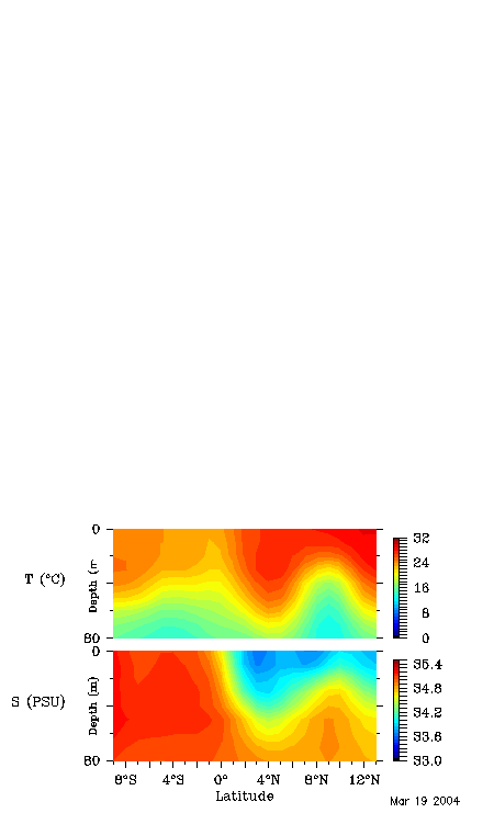
Fig. 7: June 2000 section (3min/12min)
Because of the gaps, the data return is highest directly after a maintenance
cruise. This figure show the June 2000 mean meridional section as
measured by the enhanced buoys. We see the mean meridional gradient
in BP of about 4 mb between 8S and 5N, and an interesting
plateau near the cold tongue.
The frontal region associated with the northern edge of the
cold tongue shows up in nearly all variables. Skipping down
to the middle panel here we see that Air T and SST are almost
identical at 2S and the equator, so that the air is relatively
stable. Relative humidity is also high and latent heat flux (as
well as sensible heat flux) have minimums on the equator.
Just two degrees north, the air is must more unstable. Latent
heat loss is 150 W/m2 larger. Winds are higher and the air is
much drier.
There are a couple of other things that I would like to bring
to your attention...
Although the magnitude of the winds' unit vector is twice as
large as the 10 m current vector, we can see that the currents
are a non-negligible fraction of the wind magnitude. Also, they
are not necessarily in the same direction. This means that we
need to be careful when computing the fluxes -- winds must be
relative to the ocean currents. Further, the wind stress, may
not be in the same direction as the 4 m winds, and indeed the
winds may have a slight turning to them induced by the oblique
currents.
Also, note that while the maximum rainfall is where we expect it
at 8N, the freshest waters are south, at 3.5N. Could there be
a landbased source of freshwater here? Also, what is the dynamical
effect of this buoyancy gradient?
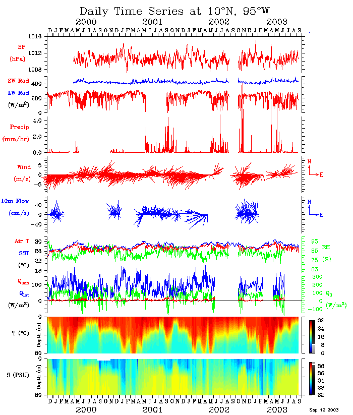
Fig. 8: 10N time series (2min/15min)
Now looking at the daily averaged time series from 10N, 95W,
We see lots of variability in BP - with a range of between 1008 mb
and 1113 mb.
SWR was within a few Watts of its climatology over the record length.
However, what I find remarkable is just how dark some days can get.
For example on Sep 27, as tropical storm Juliette was spinning
up to hurricane force, the 24-hour average SWR was less than 5 W/m2.
Finally, what is controlling this seasonal variability in the thermocline?
Is it 1-d forcing? or 3-d? How does this variability relate to the evolution
of the Costa Rica dome and local wind stress curl? These are a sampling of
some questions I hope to address with this data set.
Return to Meghan Cronin's Home Page