| xy | lat.dd | long.dd | lat-deg | lat-min | long-deg | long-min |
| gt153 | 56.38736 | 157.7779 | 56 | 23.2416 | 157 | 46.674 |
| gt155 | 56.50831 | 157.5702 | 56 | 30.4986 | 157 | 34.212 |
| gt163 | 56.99214 | 156.7328 | 56 | 59.5284 | 156 | 43.968 |
| gt169 | 57.35501 | 156.0975 | 57 | 21.3006 | 156 | 5.85 |
| gv153 | 56.27257 | 157.553 | 56 | 16.3542 | 157 | 33.18 |
| gv155 | 56.39353 | 157.3459 | 56 | 23.6118 | 157 | 20.754 |
| gv159 | 56.63544 | 156.9298 | 56 | 38.1264 | 156 | 55.788 |
| gv161 | 56.7564 | 156.7208 | 56 | 45.384 | 156 | 43.248 |
| gv163 | 56.87735 | 156.5111 | 56 | 52.641 | 156 | 30.666 |
| gv165 | 56.99831 | 156.3007 | 56 | 59.8986 | 156 | 18.042 |
| gv167 | 57.11927 | 156.0896 | 57 | 7.1562 | 156 | 5.376 |
| gv169 | 57.24022 | 155.8778 | 57 | 14.4132 | 155 | 52.668 |
| gv171 | 57.36118 | 155.6653 | 57 | 21.6708 | 155 | 39.918 |
| gv173 | 57.48214 | 155.4521 | 57 | 28.9284 | 155 | 27.126 |
| gv175 | 57.60309 | 155.2383 | 57 | 36.1854 | 155 | 14.298 |
| gv177 | 57.72405 | 155.0237 | 57 | 43.443 | 155 | 1.422 |
| gv179 | 57.84501 | 154.8083 | 57 | 50.7006 | 154 | 48.498 |
| gx153 | 56.15779 | 157.3288 | 56 | 9.4674 | 157 | 19.728 |
| gx155 | 56.27874 | 157.1224 | 56 | 16.7244 | 157 | 7.344 |
| gx157 | 56.3997 | 156.9153 | 56 | 23.982 | 156 | 54.918 |
| gx159 | 56.52066 | 156.7075 | 56 | 31.2396 | 156 | 42.45 |
| gx161 | 56.64161 | 156.4991 | 56 | 38.4966 | 156 | 29.946 |
| gx163 | 56.76257 | 156.29 | 56 | 45.7542 | 156 | 17.4 |
| gx165 | 56.88353 | 156.0803 | 56 | 53.0118 | 156 | 4.818 |
| gx167 | 57.00448 | 155.8698 | 57 | 0.2688 | 155 | 52.188 |
| gx169 | 57.12544 | 155.6587 | 57 | 7.5264 | 155 | 39.522 |
| gx171 | 57.2464 | 155.4469 | 57 | 14.784 | 155 | 26.814 |
| gx173 | 57.36735 | 155.2344 | 57 | 22.041 | 155 | 14.064 |
| gx175 | 57.48831 | 155.0212 | 57 | 29.2986 | 155 | 1.272 |
| gx177 | 57.60926 | 154.8073 | 57 | 36.5556 | 154 | 48.438 |
| gx179 | 57.73022 | 154.5927 | 57 | 43.8132 | 154 | 35.562 |
| gz153 | 56.043 | 157.1053 | 56 | 2.58 | 157 | 6.318 |
| gz155 | 56.16396 | 156.8995 | 56 | 9.8376 | 156 | 53.97 |
| gz157 | 56.28492 | 156.693 | 56 | 17.0952 | 156 | 41.58 |
| gz159 | 56.40587 | 156.4859 | 56 | 24.3522 | 156 | 29.154 |
| gz161 | 56.52683 | 156.2781 | 56 | 31.6098 | 156 | 16.686 |
| gz163 | 56.64779 | 156.0697 | 56 | 38.8674 | 156 | 4.182 |
| gz165 | 56.76874 | 155.8606 | 56 | 46.1244 | 155 | 51.636 |
| gz167 | 56.8897 | 155.6508 | 56 | 53.382 | 155 | 39.048 |
| gz169 | 57.01065 | 155.4403 | 57 | 0.639 | 155 | 26.418 |
| gz171 | 57.13161 | 155.2291 | 57 | 7.8966 | 155 | 13.746 |
| gz173 | 57.25257 | 155.0173 | 57 | 15.1542 | 155 | 1.038 |
| hb153 | 55.92822 | 156.8826 | 55 | 55.6932 | 156 | 52.956 |
| hb155 | 56.04918 | 156.6773 | 56 | 2.9508 | 156 | 40.638 |
| hb157 | 56.17013 | 156.4715 | 56 | 10.2078 | 156 | 28.29 |
| hb159 | 56.29109 | 156.265 | 56 | 17.4654 | 156 | 15.9 |
| hb161 | 56.41204 | 156.0578 | 56 | 24.7224 | 156 | 3.468 |
| hb163 | 56.533 | 155.85 | 56 | 31.98 | 155 | 51 |
| hb165 | 56.65396 | 155.6415 | 56 | 39.2376 | 155 | 38.49 |
| hb167 | 56.77491 | 155.4324 | 56 | 46.4946 | 155 | 25.944 |
| hb169 | 56.89587 | 155.2225 | 56 | 53.7522 | 155 | 13.35 |
| hb171 | 57.01683 | 155.012 | 57 | 1.0098 | 155 | 0.72 |
| hd151 | 55.69248 | 156.8644 | 55 | 41.5488 | 156 | 51.864 |
| hd153 | 55.81343 | 156.6605 | 55 | 48.8058 | 156 | 39.63 |
| hd155 | 55.93439 | 156.4559 | 55 | 56.0634 | 156 | 27.354 |
| hd157 | 56.05535 | 156.2506 | 56 | 3.321 | 156 | 15.036 |
| hd159 | 56.1763 | 156.0447 | 56 | 10.578 | 156 | 2.682 |
| hd161 | 56.29726 | 155.8382 | 56 | 17.8356 | 155 | 50.292 |
| hd163 | 56.41822 | 155.631 | 56 | 25.0932 | 155 | 37.86 |
| hd165 | 56.53917 | 155.4231 | 56 | 32.3502 | 155 | 25.386 |
| hf151 | 55.57769 | 156.6424 | 55 | 34.6614 | 156 | 38.544 |
| hf153 | 55.69865 | 156.439 | 55 | 41.919 | 156 | 26.34 |
| hf155 | 55.81961 | 156.235 | 55 | 49.1766 | 156 | 14.1 |
| hf157 | 55.94056 | 156.0304 | 55 | 56.4336 | 156 | 1.824 |
| hf159 | 56.06152 | 155.8251 | 56 | 3.6912 | 155 | 49.506 |
| hh151 | 55.46291 | 156.4211 | 55 | 27.7746 | 156 | 25.266 |
| hh153 | 55.58387 | 156.2183 | 55 | 35.0322 | 156 | 13.098 |
| hh155 | 55.70482 | 156.0149 | 55 | 42.2892 | 156 | 0.894 |
| hh157 | 55.82578 | 155.8109 | 55 | 49.5468 | 155 | 48.654 |
| hj149 | 55.22717 | 156.402 | 55 | 13.6302 | 156 | 24.12 |
| hj151 | 55.34813 | 156.2004 | 55 | 20.8878 | 156 | 12.024 |
| hj153 | 55.46908 | 155.9982 | 55 | 28.1448 | 155 | 59.892 |
| hj155 | 55.59004 | 155.7954 | 55 | 35.4024 | 155 | 47.724 |
| hj157 | 55.71099 | 155.592 | 55 | 42.6594 | 155 | 35.52 |
| gu158 | 56.6667 | 157.2167 | 56 | 40 | 157 | 13 |
| gt171 | 57.45 | 155.7667 | 57 | 27 | 155 | 46 |
| gt173 | 57.6167 | 155.4667 | 57 | 37 | 155 | 28 |
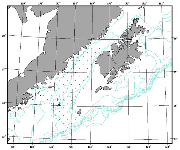
Figure A1. Main grid stations planned for occupation.
APPENDIX A2. Location of all potential stations on ichthyoplankton
grid.
| xy | lat.dd | long.dd | lat-deg | lat-min | long-deg | long-min |
| gr151 | 56.38118 | 158.2111 | 56 | 22.8708 | 158 | 12.666 |
| gt151 | 56.2664 | 157.9849 | 56 | 15.984 | 157 | 59.094 |
| gt153 | 56.38736 | 157.7779 | 56 | 23.2416 | 157 | 46.674 |
| gt155 | 56.50831 | 157.5702 | 56 | 30.4986 | 157 | 34.212 |
| gt163 | 56.99214 | 156.7328 | 56 | 59.5284 | 156 | 43.968 |
| gt169 | 57.35501 | 156.0975 | 57 | 21.3006 | 156 | 5.85 |
| gv149 | 56.03066 | 157.9651 | 56 | 1.8396 | 157 | 57.906 |
| gv151 | 56.15162 | 157.7594 | 56 | 9.0972 | 157 | 45.564 |
| gv153 | 56.27257 | 157.553 | 56 | 16.3542 | 157 | 33.18 |
| gv155 | 56.39353 | 157.3459 | 56 | 23.6118 | 157 | 20.754 |
| gv159 | 56.63544 | 156.9298 | 56 | 38.1264 | 156 | 55.788 |
| gv161 | 56.7564 | 156.7208 | 56 | 45.384 | 156 | 43.248 |
| gv163 | 56.87735 | 156.5111 | 56 | 52.641 | 156 | 30.666 |
| gv165 | 56.99831 | 156.3007 | 56 | 59.8986 | 156 | 18.042 |
| gv167 | 57.11927 | 156.0896 | 57 | 7.1562 | 156 | 5.376 |
| gv169 | 57.24022 | 155.8778 | 57 | 14.4132 | 155 | 52.668 |
| gv171 | 57.36118 | 155.6653 | 57 | 21.6708 | 155 | 39.918 |
| gv173 | 57.48214 | 155.4521 | 57 | 28.9284 | 155 | 27.126 |
| gv175 | 57.60309 | 155.2383 | 57 | 36.1854 | 155 | 14.298 |
| gv177 | 57.72405 | 155.0237 | 57 | 43.443 | 155 | 1.422 |
| gv179 | 57.84501 | 154.8083 | 57 | 50.7006 | 154 | 48.498 |
| gx149 | 55.91587 | 157.7397 | 55 | 54.9522 | 157 | 44.382 |
| gx151 | 56.03683 | 157.5346 | 56 | 2.2098 | 157 | 32.076 |
| gx153 | 56.15779 | 157.3288 | 56 | 9.4674 | 157 | 19.728 |
| gx155 | 56.27874 | 157.1224 | 56 | 16.7244 | 157 | 7.344 |
| gx157 | 56.3997 | 156.9153 | 56 | 23.982 | 156 | 54.918 |
| gx159 | 56.52066 | 156.7075 | 56 | 31.2396 | 156 | 42.45 |
| gx161 | 56.64161 | 156.4991 | 56 | 38.4966 | 156 | 29.946 |
| gx163 | 56.76257 | 156.29 | 56 | 45.7542 | 156 | 17.4 |
| gx165 | 56.88353 | 156.0803 | 56 | 53.0118 | 156 | 4.818 |
| gx167 | 57.00448 | 155.8698 | 57 | 0.2688 | 155 | 52.188 |
| gx169 | 57.12544 | 155.6587 | 57 | 7.5264 | 155 | 39.522 |
| gx171 | 57.2464 | 155.4469 | 57 | 14.784 | 155 | 26.814 |
| gx173 | 57.36735 | 155.2344 | 57 | 22.041 | 155 | 14.064 |
| gx175 | 57.48831 | 155.0212 | 57 | 29.2986 | 155 | 1.272 |
| gx177 | 57.60926 | 154.8073 | 57 | 36.5556 | 154 | 48.438 |
| gx179 | 57.73022 | 154.5927 | 57 | 43.8132 | 154 | 35.562 |
| gx181 | 57.85118 | 154.3773 | 57 | 51.0708 | 154 | 22.638 |
| gx183 | 57.97213 | 154.1612 | 57 | 58.3278 | 154 | 9.672 |
| gx185 | 58.09309 | 153.9444 | 58 | 5.5854 | 153 | 56.664 |
| gx187 | 58.21405 | 153.7269 | 58 | 12.843 | 153 | 43.614 |
| gx189 | 58.335 | 153.5086 | 58 | 20.1 | 153 | 30.516 |
| gx191 | 58.45596 | 153.2895 | 58 | 27.3576 | 153 | 17.37 |
| gx193 | 58.57692 | 153.0697 | 58 | 34.6152 | 153 | 4.182 |
| gx195 | 58.69787 | 152.8492 | 58 | 41.8722 | 152 | 50.952 |
| gx197 | 58.81883 | 152.6279 | 58 | 49.1298 | 152 | 37.674 |
| gz149 | 55.80109 | 157.515 | 55 | 48.0654 | 157 | 30.9 |
| gz151 | 55.92205 | 157.3105 | 55 | 55.323 | 157 | 18.63 |
| gz153 | 56.043 | 157.1053 | 56 | 2.58 | 157 | 6.318 |
| gz155 | 56.16396 | 156.8995 | 56 | 9.8376 | 156 | 53.97 |
| gz157 | 56.28492 | 156.693 | 56 | 17.0952 | 156 | 41.58 |
| gz159 | 56.40587 | 156.4859 | 56 | 24.3522 | 156 | 29.154 |
| gz161 | 56.52683 | 156.2781 | 56 | 31.6098 | 156 | 16.686 |
| gz163 | 56.64779 | 156.0697 | 56 | 38.8674 | 156 | 4.182 |
| gz165 | 56.76874 | 155.8606 | 56 | 46.1244 | 155 | 51.636 |
| gz167 | 56.8897 | 155.6508 | 56 | 53.382 | 155 | 39.048 |
| gz169 | 57.01065 | 155.4403 | 57 | 0.639 | 155 | 26.418 |
| gz171 | 57.13161 | 155.2291 | 57 | 7.8966 | 155 | 13.746 |
| gz173 | 57.25257 | 155.0173 | 57 | 15.1542 | 155 | 1.038 |
| gz175 | 57.37352 | 154.8047 | 57 | 22.4112 | 154 | 48.282 |
| gz177 | 57.49448 | 154.5915 | 57 | 29.6688 | 154 | 35.49 |
| gz179 | 57.61544 | 154.3775 | 57 | 36.9264 | 154 | 22.65 |
| gz181 | 57.73639 | 154.1629 | 57 | 44.1834 | 154 | 9.774 |
| gz183 | 57.85735 | 153.9475 | 57 | 51.441 | 153 | 56.85 |
| gz185 | 57.97831 | 153.7314 | 57 | 58.6986 | 153 | 43.884 |
| gz187 | 58.09926 | 153.5145 | 58 | 5.9556 | 153 | 30.87 |
| gz189 | 58.22022 | 153.297 | 58 | 13.2132 | 153 | 17.82 |
| gz191 | 58.34118 | 153.0786 | 58 | 20.4708 | 153 | 4.716 |
| gz193 | 58.46213 | 152.8596 | 58 | 27.7278 | 152 | 51.576 |
| gz195 | 58.58309 | 152.6397 | 58 | 34.9854 | 152 | 38.382 |
| gz197 | 58.70404 | 152.4191 | 58 | 42.2424 | 152 | 25.146 |
| hb149 | 55.68631 | 157.2911 | 55 | 41.1786 | 157 | 17.466 |
| hb151 | 55.80726 | 157.0871 | 55 | 48.4356 | 157 | 5.226 |
| hb153 | 55.92822 | 156.8826 | 55 | 55.6932 | 156 | 52.956 |
| hb155 | 56.04918 | 156.6773 | 56 | 2.9508 | 156 | 40.638 |
| hb157 | 56.17013 | 156.4715 | 56 | 10.2078 | 156 | 28.29 |
| hb159 | 56.29109 | 156.265 | 56 | 17.4654 | 156 | 15.9 |
| hb161 | 56.41204 | 156.0578 | 56 | 24.7224 | 156 | 3.468 |
| hb163 | 56.533 | 155.85 | 56 | 31.98 | 155 | 51 |
| hb165 | 56.65396 | 155.6415 | 56 | 39.2376 | 155 | 38.49 |
| hb167 | 56.77491 | 155.4324 | 56 | 46.4946 | 155 | 25.944 |
| hb169 | 56.89587 | 155.2225 | 56 | 53.7522 | 155 | 13.35 |
| hb171 | 57.01683 | 155.012 | 57 | 1.0098 | 155 | 0.72 |
| hb173 | 57.13778 | 154.8008 | 57 | 8.2668 | 154 | 48.048 |
| hb187 | 57.98448 | 153.3028 | 57 | 59.0688 | 153 | 18.168 |
| hb199 | 58.71022 | 151.9903 | 58 | 42.6132 | 151 | 59.418 |
| hd149 | 55.57152 | 157.0678 | 55 | 34.2912 | 157 | 4.068 |
| hd151 | 55.69248 | 156.8644 | 55 | 41.5488 | 156 | 51.864 |
| hd153 | 55.81343 | 156.6605 | 55 | 48.8058 | 156 | 39.63 |
| hd155 | 55.93439 | 156.4559 | 55 | 56.0634 | 156 | 27.354 |
| hd157 | 56.05535 | 156.2506 | 56 | 3.321 | 156 | 15.036 |
| hd159 | 56.1763 | 156.0447 | 56 | 10.578 | 156 | 2.682 |
| hd161 | 56.29726 | 155.8382 | 56 | 17.8356 | 155 | 50.292 |
| hd163 | 56.41822 | 155.631 | 56 | 25.0932 | 155 | 37.86 |
| hd165 | 56.53917 | 155.4231 | 56 | 32.3502 | 155 | 25.386 |
| hd167 | 56.66013 | 155.2146 | 56 | 39.6078 | 155 | 12.876 |
| hd169 | 56.78109 | 155.0054 | 56 | 46.8654 | 155 | 0.324 |
| hd171 | 56.90204 | 154.7956 | 56 | 54.1224 | 154 | 47.736 |
| hd173 | 57.023 | 154.5851 | 57 | 1.38 | 154 | 35.106 |
| hd197 | 58.47448 | 152.0034 | 58 | 28.4688 | 152 | 0.204 |
| hd199 | 58.59543 | 151.7835 | 58 | 35.7258 | 151 | 47.01 |
| hf149 | 55.45674 | 156.8452 | 55 | 27.4044 | 156 | 50.712 |
| hf151 | 55.57769 | 156.6424 | 55 | 34.6614 | 156 | 38.544 |
| hf153 | 55.69865 | 156.439 | 55 | 41.919 | 156 | 26.34 |
| hf155 | 55.81961 | 156.235 | 55 | 49.1766 | 156 | 14.1 |
| hf157 | 55.94056 | 156.0304 | 55 | 56.4336 | 156 | 1.824 |
| hf159 | 56.06152 | 155.8251 | 56 | 3.6912 | 155 | 49.506 |
| hf161 | 56.18248 | 155.6192 | 56 | 10.9488 | 155 | 37.152 |
| hf163 | 56.30343 | 155.4126 | 56 | 18.2058 | 155 | 24.756 |
| hf165 | 56.42439 | 155.2054 | 56 | 25.4634 | 155 | 12.324 |
| hf167 | 56.54535 | 154.9975 | 56 | 32.721 | 154 | 59.85 |
| hf169 | 56.6663 | 154.789 | 56 | 39.978 | 154 | 47.34 |
| hf171 | 56.78726 | 154.5798 | 56 | 47.2356 | 154 | 34.788 |
| hf173 | 56.90821 | 154.3699 | 56 | 54.4926 | 154 | 22.194 |
| hf191 | 57.99682 | 152.4495 | 57 | 59.8092 | 152 | 26.97 |
| hf197 | 58.35969 | 151.7964 | 58 | 21.5814 | 151 | 47.784 |
| hf199 | 58.48065 | 151.5772 | 58 | 28.839 | 151 | 34.632 |
| hh149 | 55.34195 | 156.6232 | 55 | 20.517 | 156 | 37.392 |
| hh151 | 55.46291 | 156.4211 | 55 | 27.7746 | 156 | 25.266 |
| hh153 | 55.58387 | 156.2183 | 55 | 35.0322 | 156 | 13.098 |
| hh155 | 55.70482 | 156.0149 | 55 | 42.2892 | 156 | 0.894 |
| hh157 | 55.82578 | 155.8109 | 55 | 49.5468 | 155 | 48.654 |
| hh159 | 55.94674 | 155.6062 | 55 | 56.8044 | 155 | 36.372 |
| hh161 | 56.06769 | 155.4009 | 56 | 4.0614 | 155 | 24.054 |
| hh163 | 56.18865 | 155.1949 | 56 | 11.319 | 155 | 11.694 |
| hh165 | 56.3096 | 154.9883 | 56 | 18.576 | 154 | 59.298 |
| hh171 | 56.67247 | 154.3646 | 56 | 40.3482 | 154 | 21.876 |
| hh173 | 56.79343 | 154.1553 | 56 | 47.6058 | 154 | 9.318 |
| hh175 | 56.91439 | 153.9454 | 56 | 54.8634 | 153 | 56.724 |
| hh193 | 58.00299 | 152.0247 | 58 | 0.1794 | 152 | 1.482 |
| hh195 | 58.12395 | 151.8077 | 58 | 7.437 | 151 | 48.462 |
| hh197 | 58.24491 | 151.59 | 58 | 14.6946 | 151 | 35.4 |
| hh199 | 58.36586 | 151.3715 | 58 | 21.9516 | 151 | 22.29 |
| hj149 | 55.22717 | 156.402 | 55 | 13.6302 | 156 | 24.12 |
| hj151 | 55.34813 | 156.2004 | 55 | 20.8878 | 156 | 12.024 |
| hj153 | 55.46908 | 155.9982 | 55 | 28.1448 | 155 | 59.892 |
| hj155 | 55.59004 | 155.7954 | 55 | 35.4024 | 155 | 47.724 |
| hj157 | 55.71099 | 155.592 | 55 | 42.6594 | 155 | 35.52 |
| hj159 | 55.83195 | 155.3879 | 55 | 49.917 | 155 | 23.274 |
| hj161 | 55.95291 | 155.1832 | 55 | 57.1746 | 155 | 10.992 |
| hj163 | 56.07386 | 154.9779 | 56 | 4.4316 | 154 | 58.674 |
| hj165 | 56.19482 | 154.7719 | 56 | 11.6892 | 154 | 46.314 |
| hj167 | 56.31578 | 154.5653 | 56 | 18.9468 | 154 | 33.918 |
| hj169 | 56.43673 | 154.358 | 56 | 26.2038 | 154 | 21.48 |
| hj173 | 56.67865 | 153.9414 | 56 | 40.719 | 153 | 56.484 |
| hj191 | 57.76725 | 152.033 | 57 | 46.035 | 152 | 1.98 |
| hj193 | 57.88821 | 151.8175 | 57 | 53.2926 | 151 | 49.05 |
| hj195 | 58.00917 | 151.6012 | 58 | 0.5502 | 151 | 36.072 |
| hj197 | 58.13012 | 151.3841 | 58 | 7.8072 | 151 | 23.046 |
| hj199 | 58.25108 | 151.1664 | 58 | 15.0648 | 151 | 9.984 |
| hl149 | 55.11238 | 156.1814 | 55 | 6.7428 | 156 | 10.884 |
| hl151 | 55.23334 | 155.9805 | 55 | 14.0004 | 155 | 58.83 |
| hl153 | 55.3543 | 155.7789 | 55 | 21.258 | 155 | 46.734 |
| hl155 | 55.47525 | 155.5766 | 55 | 28.515 | 155 | 34.596 |
| hl157 | 55.59621 | 155.3738 | 55 | 35.7726 | 155 | 22.428 |
| hl159 | 55.71717 | 155.1703 | 55 | 43.0302 | 155 | 10.218 |
| hl161 | 55.83812 | 154.9662 | 55 | 50.2872 | 154 | 57.972 |
| hl163 | 55.95908 | 154.7615 | 55 | 57.5448 | 154 | 45.69 |
| hl165 | 56.08004 | 154.5561 | 56 | 4.8024 | 154 | 33.366 |
| hl167 | 56.20099 | 154.3501 | 56 | 12.0594 | 154 | 21.006 |
| hl169 | 56.32195 | 154.1434 | 56 | 19.317 | 154 | 8.604 |
| hl173 | 56.56386 | 153.7281 | 56 | 33.8316 | 153 | 43.686 |
| hl175 | 56.68482 | 153.5195 | 56 | 41.0892 | 153 | 31.17 |
| hl177 | 56.80577 | 153.3102 | 56 | 48.3462 | 153 | 18.612 |
| hl179 | 56.92673 | 153.1002 | 56 | 55.6038 | 153 | 6.012 |
| hl181 | 57.04769 | 152.8895 | 57 | 2.8614 | 152 | 53.37 |
| hl183 | 57.16864 | 152.6781 | 57 | 10.1184 | 152 | 40.686 |
| hl185 | 57.2896 | 152.466 | 57 | 17.376 | 152 | 27.96 |
| hl187 | 57.41056 | 152.2533 | 57 | 24.6336 | 152 | 15.198 |
| hl189 | 57.53151 | 152.0398 | 57 | 31.8906 | 152 | 2.388 |
| hl191 | 57.65247 | 151.8257 | 57 | 39.1482 | 151 | 49.542 |
| hl193 | 57.77343 | 151.6108 | 57 | 46.4058 | 151 | 36.648 |
| hl195 | 57.89438 | 151.3952 | 57 | 53.6628 | 151 | 23.712 |
| hl197 | 58.01534 | 151.1788 | 58 | 0.9204 | 151 | 10.728 |
| hl199 | 58.1363 | 150.9617 | 58 | 8.178 | 150 | 57.702 |
| hn149 | 54.9976 | 155.9615 | 54 | 59.856 | 155 | 57.69 |
| hn151 | 55.11856 | 155.7611 | 55 | 7.1136 | 155 | 45.666 |
| hn153 | 55.23951 | 155.5601 | 55 | 14.3706 | 155 | 33.606 |
| hn155 | 55.36047 | 155.3585 | 55 | 21.6282 | 155 | 21.51 |
| hn157 | 55.48143 | 155.1562 | 55 | 28.8858 | 155 | 9.372 |
| hn159 | 55.60238 | 154.9534 | 55 | 36.1428 | 154 | 57.204 |
| hn161 | 55.72334 | 154.7499 | 55 | 43.4004 | 154 | 44.994 |
| hn163 | 55.8443 | 154.5457 | 55 | 50.658 | 154 | 32.742 |
| hn165 | 55.96525 | 154.341 | 55 | 57.915 | 154 | 20.46 |
| hn167 | 56.08621 | 154.1356 | 56 | 5.1726 | 154 | 8.136 |
| hn169 | 56.20716 | 153.9295 | 56 | 12.4296 | 153 | 55.77 |
| hn171 | 56.32812 | 153.7228 | 56 | 19.6872 | 153 | 43.368 |
| hn173 | 56.44908 | 153.5155 | 56 | 26.9448 | 153 | 30.93 |
| hn175 | 56.57003 | 153.3075 | 56 | 34.2018 | 153 | 18.45 |
| hn177 | 56.69099 | 153.0988 | 56 | 41.4594 | 153 | 5.928 |
| hn179 | 56.81195 | 152.8894 | 56 | 48.717 | 152 | 53.364 |
| hn181 | 56.9329 | 152.6794 | 56 | 55.974 | 152 | 40.764 |
| hn183 | 57.05386 | 152.4687 | 57 | 3.2316 | 152 | 28.122 |
| hn185 | 57.17482 | 152.2573 | 57 | 10.4892 | 152 | 15.438 |
| hn187 | 57.29577 | 152.0452 | 57 | 17.7462 | 152 | 2.712 |
| hn189 | 57.41673 | 151.8324 | 57 | 25.0038 | 151 | 49.944 |
| hn191 | 57.53769 | 151.6189 | 57 | 32.2614 | 151 | 37.134 |
| hn193 | 57.65864 | 151.4047 | 57 | 39.5184 | 151 | 24.282 |
| hn195 | 57.7796 | 151.1897 | 57 | 46.776 | 151 | 11.382 |
| hn197 | 57.90055 | 150.9741 | 57 | 54.033 | 150 | 58.446 |
| hn199 | 58.02151 | 150.7577 | 58 | 1.2906 | 150 | 45.462 |
| gu158 | 56.6667 | 157.2167 | 56 | 40 | 157 | 13 |
| gt171 | 57.45 | 155.7667 | 57 | 27 | 155 | 46 |
| gt173 | 57.6167 | 155.4667 | 57 | 37 | 155 | 28 |
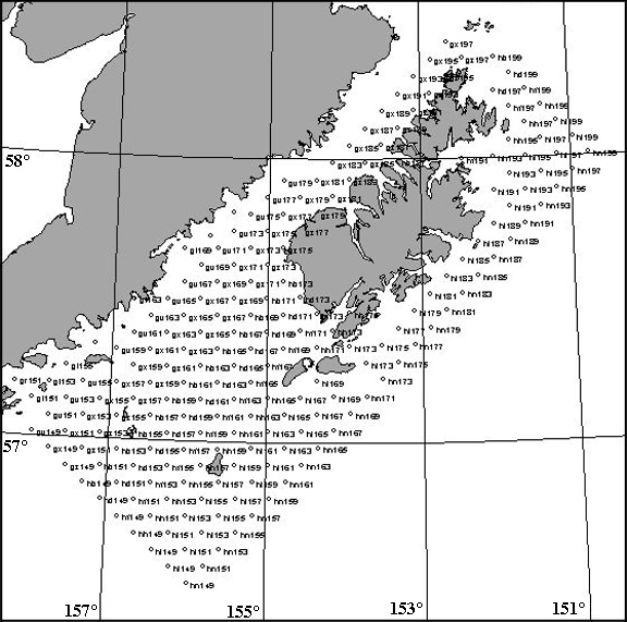
Figure A2. Overall grid of potential stations.
APPENDIX A3. Station positions and activities at Line 8.
| Station | LatDDeg | LongDDeg | LatDeg | LatMin | LongDeg | LongMin | CTDB | Chlorophyll | Nutrients | Macrozooplankton | 20/60Bongo3 |
| FOX61 | 57.72 | -155.26 | 57 | 43.2 | 155 | 15.6 | x | x | x | x | x |
| FOX60 | 57.68 | -155.17 | 57 | 41 | 155 | 10 | x | x | x | x | x |
| FOX59 | 57.64 | -155.07 | 57 | 38.5 | 155 | 4.2 | x | x | x | x | x |
| FOX58 | 57.61 | -155.01 | 57 | 36.3 | 155 | 0.5 | x | x | x | x | x |
| FOX57 | 57.55 | -154.88 | 57 | 33.1 | 154 | 52.5 | x | x | x | x | x |
| FOX56 | 57.52 | -154.78 | 57 | 30.9 | 154 | 47 | x | x | x | x | x |
| FOX55 | 57.48 | -154.7 | 57 | 28.5 | 154 | 42 | x | x | x | x | x |
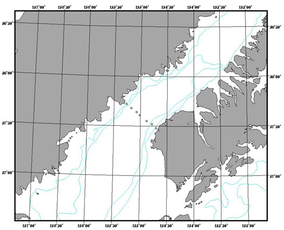
Figure A3. Stations of Line 8.
APPENDIX B APPLICABLE STANDARD OPERATING INSTRUCTIONS
2.2.1 CTD / Water Sample Operations
A Sea-Bird 9Plus CTD with dual thermistor and conductivity cells will be the primary system. A backup Sea-Bird 9Plus CTD is required. When available, and where possible, the FOCI fluorometer, light meter, and chlorophyll absorbance meter (ChlAM) should be mounted on the CTD stand for all casts. However, the ChlAM can not exceed 300m, the fluorometer cannot exceed 500m, and the light meter cannot exceed 1000m. On selected casts, biological samples will be collected. Water for microzooplankton samples will be collected using 10-l Niskin bottles. When only nutrient or chlorophyll water samples are required, smaller Nisken bottles may be used.
Once the CTD has been deployed, it should be lowered to 10m. The deck unit should be turned on. If a ChlAM is attached, the CTD should remain at 10m for three minutes; otherwise after 45 seconds the CTD can be returned to just below the surface. Then the data acquisition program and VHS cassette CTD tape backup system should be started. The CTD should descend at a rate of 30m/min for the first 200m and 45m/min below that. The ascent rate should be 50m/min. One exception to the descent rates occurs on the Bering Shelf in water less than 150m deep - in this case, the CTD should descend at 10 m/min during the entire cast. An entry in the MOA should be made for each CTD cast at the maximum cast depth.
CTD data will be acquired using SEASOFT software on the ships computer. The capability to display CTD data using the SCS system and monitors will be available. Survey Technicians and scientists will keep the "CTD Cast Information/Rosette Log". Pressure, primary salinity, primary temperature, secondary temperature, fluorescence, ChlAM chlorophyll concentration and light levels will be recorded on the "CTD Cast Information/Rosette Log" for all water bottle samples.
CTD Calibration: Salinity samples will be taken on every cast (or as specified by the Chief Scientist). No reversing thermometers will be required. The CTD systems will be equipped with dual thermistors. A Survey Technician will run AutoSal analysis during the cruise and record the readings on an AutoSal log.
2.2.2 MARMAP bongo tows
A 60-cm bongo net with 0.505 mm nets, (or 0.333 mm before mid May) hard plastic codends and a 40 kg lead weight for a depressor will be used in standard MARMAP tows. The nets will be deployed at a constant wire speed of 40 m/min to a maximum depth of 100 m (or 200 m before mid May) or 10 m off bottom in shallower waters, however, at stations on Lines 8, 16 and 17 in Shelikof Strait nets will be towed from 10 m off bottom to surface. In addition, one side of the 60 cm bongo will be changed to 0.333 mm mesh. Furthermore the 20 cm bongo with 0.150 mm mesh nets will be attached to the wire 1 m above the 60 cm bongo frame at Line 8, and at selected other stations. A CTD (Seacat) or electronic BKG will be attached to the wire to provide real-time tow data. The depth of the nets will be monitored by the scientists, and commands given to stop the winch. The winch will be stopped and the nets allowed to stabilize for up to 30 sec. The nets are then retrieved at a wire speed of 20 m/min. The ship speed is adjusted to maintain a wire angle of 45 degrees during the entire tow. When the nets reach the surface they are brought aboard and hosed to wash the sample into the codend. The sample is preserved appropriately. In some cases, larvae are sorted and preserved separately. Flow meters in the nets record the amount of water filtered and an electronic CTD or bathykymograph records the depth history of the tow. The Scientists on watch are responsible for recording times and maximum depth obtained in the Seacat logbook. Tows not meeting specifications may be repeated at the discretion of the scientific watch.
The PMEL SeaCat data will be acquired on the ships computer using SEASOFT software. The option to display Seacat data using the SCS system and monitors will be available.
2.2.3 Bongo Larval Condition Tows
A live tow for larval pollock uses the 60cm bongo with 0.333mm or 0.505mm net mesh with taped codends. The selection of the mesh size will depend on the time of field collections, larval size, amount of algae, etc. This is a vertical tow with the ship's speed used only to maintain a zero wire angle. The SEACAT is on the wire and data is saved for each haul. The bongo is lowered at 25-30 m/min to a gear depth of 70 meters. The wire in speed should be 10 m/min, begin timing the tow when the net starts up. Do not rinse down the nets when they return to the deck, but do open the codends immediately into clean (live) 5 gallon buckets. The samples are carefully transferred into a bowl over ice and are sorted quickly for live larvae. Preserve larvae immediately, as specified in FOCI field manual or sample collection request forms. The net is rinsed between tows.
2.2.4 Live Zooplankton Ring Net Tows
Tows to collect experimental animals for secondary productivity experiments will be taken during large-scale surveys and patch studies. These collections use a special net, which minimizes damage to the organisms. The net will be deployed using the same CTD winch used for bongo tows. The ship will be asked to keep station for this vertical tow. A 0.8 m ring net with a large polycarbonate codend and the Seacat will be "book clamped" to the wire. The net will be lowered at a rate of 20 m/min to near the bottom, then retrieved at a rate of 10-20 m/min
2.2.5 MOCNESS tows
Deck Machinery -- The Multiple Opening/Closing Net and Environmental Sensing System (MOCNESS) is deployed whenever possible using the Traction winch and the A-frame. The instrument will require 600-1500 m of single conductor wire. In addition, a set of slip rings are requested for the winch. The manufacturer states that the maximum drag observed on a 1 m2 MOCNESS system was 3,000 pounds. If we include a 2-3X safety factor, the conducting cable should have a minimum breaking strength of 6,000-9,000 pounds.
Electronics -- The MOCNESS telemeters, in real time, conductivity, temperature, depth, and flow meter data to the surface. FOCI owns two, separate electronic systems for the MOCNESS frame. The older system consists of two 6" OD pressure cases that sit in separate cradles on the net frame and telemeter data to the ship at 1 frame every four seconds. The signal is received on a MOCNESS PC computer by a data acquisition deck box and simultaneously routed to an old 286 Compaq luggable computer and a VCR for analog signal backup. A dot matrix printer is used to print data from every other scan. Serial input (RS-232) from the ships scientific GPS unit is required to obtain continuous position data for the data stream. The data acquisition system (DAS) software requires a single NMEA 0183 string ($ GPGGA) for input to COM2. All acquisition programs are written in TurboPascal 5.0 and exist as both source code and compiled executable code. All DAS hardware components sit in the electronics rack.
The "new" system consists of two, 4" OD pressure cases that sit in the same cradle on the MOCNESS frame and telemeter data to the ship as fast as 1 frame per second. The signal is received by a serial modem and is routed to a PC Pentium computer under the bench on the starboard bulkhead. The analog signal is not recorded. The MOCNESS acquisition station shares a monitor with the CTD/SeaCat data acquisition system. Serial input of GPS data is required as for the older system. The data acquisition software are written in Visual Basic running under Windows 3.1, and we only have the compiled executable file..
Launch, Fishing, & Recovery -- The movable MOCNESS support frame will be used. The MOCNESS is launched and recovered from the stern. For safe, efficient launch and recovery of the MOCNESS, the Survey Technician is asked to lead those procedures, giving orders to the trawl house while the Scientific Watch handles the tag lines. When the weather is rough, a member of the deck dept may be requested to assist in the deployment and recovery.
The MOCNESS pilot will relay instructions to the winch operator and the bridge to control the descent/ascent of the net system. It is essential that the ship maintain a constant speed through the water during the tow. Wire in/out rates must be available to the winch operator and should be availbale to the MOCNESS pilot as well. The MOCNESS is deployed and recovered while under way (1.5 knots). Wire is paid out at a rate of 5-25 m/min and is retrieved at 5-20 m/min under the direction of the pilot. The MOCNESS pilot will inform the bridge as each net is closed and request that the bridge record the position in the MOA. After recovery, the MOCNESS nets are washed down on the aft deck.
2.2.6 CalCOFI Vertical Egg Tow (CalVET)
Vertical tows to collect microzooplankton and free-floating copepod eggs will be conducted, sometimes in conjunction with CTD/bottle casts. When done in conjunction with a CTD cast, the CTD will be stopped at 15 m during its descent, and the net frame's top and bottom will be attached to the wire so that the net flushes during its descent while the ship stands hove to. After descent to desired depth (usually 60 m), the net will then be retrieved at a rate of 60 m/min. The samples will be washed into the cod ends, then preserved in 32 oz. jars with formalin for later analysis. Once the net frame has been removed from the wire, then the CTD/bottle cast can begin. The CalVET net can also be deployed from the starboard quarterdeck. When done without the CTD, the Seacat should be attached below the net.
2.2.10 Chlorophyll Samples
Chlorophyll samples will be taken from the 10-l Niskin bottles. Sampling depths depend on the fluorescence or ChlAM profile. A typical strategy would be samples at 0, 10, 20, 30, 40, and 50 or 60 m depending upon which is closest to the fluorescence or chlorophyll maximum. If the maximum is deeper, sampling should be moved deeper with less samples in the mixed layer.
When microzooplankton samples are to be collected from the same Niskin bottle, 500 ml of water is first removed from the water bottle using a graduated cylinder. Chlorophyll and nutrient samples are obtained from the 500 ml in the graduated cylinder. See the FOCI Field manual for sampling collection, filtration and preserving details. Chlorophyll and nutrient samples will be stored in conventional freezers.
2.2.11 Satellite tracked drifter buoys
Two to three working days before deployment the Chief Scientist or designated person will secure the drifter on the back deck, turn it on (usually by removing the magnet), and send an e-mail message to Dr. Phyllis Stabeno (stabeno@ pmel.noaa.gov) stating the serial number (which is stamped on the drifter) and the time that it was turned on. The method of deployment of the drifter is dependent upon the particular make of drifter and is to be directed by the Chief Scientist or designated person.
2.2.13 ADCP
ADCP Observations: The purpose of the Vessel-Mounted Acoustic Doppler Current Profiler (VM-ADCP) is to measure the ocean current velocity continuously over the upper 300 m of the water column, usually in 8 m depth increments. Current velocities relative to the earth at this spatial and temporal resolution cannot be measured by other methods: CTD sections, current meter moorings, or drifting buoys. ADCP data is also used to estimate the abundance and distribution of biological scatterers over the same depth range and in the same depth increments.
ADCP Data Collection: ADCP measurement requires four instruments working in concert: the ADCP, the ship's gyrocompass, a GPS receiver, and a GPS Attitude Determination Unit (ADU), such as the Seapath 200. The ADCP is connected to a dedicated PC and controlled by RD Instruments' Data Acquisition System (DAS) software. Version 2.48 of DAS software will be used as the controlling software. The DAS software shall be configured to use the user-exit programs AGCAVE.COM and UE4.EXE. Separate written instructions detailing the ADCP setup and configuration files are kept in the ADCP notebook in the Computer lab.
The ADCP PC is interfaced to the ship's gyrocompass, to the primary scientific GPS receiver, and to the GPS Attitude Determination Unit. The navigation GPS shall be configured to send only NMEA-0183 messages $GPGGA and $GPVTG at the maximum fix update rate for the receiver (usually 1 or 2 second rate), and with the maximum number of digits of precision (optimally 4). The Attitude Determination Unit shall be configured to send the $PASHR message at least once, preferably twice, per second, and the NMEA-0183 message $GPGGA once each second. The user-exit program UE4.EXE shall be configured to control acquisition and processing of GPS and ADU messages, and to synchronize the PC clock with the time reported by the primary GPS.
The ADCP PC logs data from the profiler to Iomega Zip disks and optionally sends a complete data structure to SCS for logging on that system. This redundancy in data logging is desirable for post-cruise processing flexibility. The user-exit program UE4.EXE should be configured to send an "RDI-style" ensemble to SCS.
PMEL supplies the Iomega Zip drives for FOCI projects. No more than one Iomega Zip disks will be required for the cruise. At the end of the cruise, a backup of the Iomega Zip disks should be made to a unique subdirectory of another disk maintained by the ship for this purpose until the original data is certified "error free" at PMEL.
Detailed, post-cruise processing of ADCP data is designed to take advantage of a higher quantity of navigation data than is retained by the ADCP acquisition software. Thus, the ship's SCS is relied on to log GPS navigation data at maximum available rates. The SCS system shall log output from the best two navigation receivers at all times during a cruise. For the purpose of designating a primary and secondary GPS system, precedence shall be assigned according to the following list of GPS receivers available on the Ron Brown:
a. P-code GPS receiver
b. Differential GPS receiver (DGPS)
c. P-code GPS receiver operating without encryption key (SPS-GPS)
d. Differential GPS receiver without differential corrections (SPS-GPS)
Changes in the availability of GPS equipment shall be communicated to PMEL to allow the above list to remain current. It is the responsibility of the ship to install and enable the appropriate encryption key for use of a PPS-GPS receiver.
The SCS file SENSOR.DAT should be configured to enable logging only of the NMEA-0183 format messages $GPGGA and $GPVTG from navigation sources; derived sensor messages are not desirable for post-cruise processing. Similarly, only raw messages from the gyrocompass ($HEHDT) are desirable for logging. SCS should log the primary GPS data at 1 second intervals, the secondary GPS data at 10 second intervals, and gyro data at 10 second intervals. The latter are used for adjusting the acoustic backscattered signal strength to absolute levels and relating the signal to biological scatterers.
ADCP Underway Operations: The ADCP operates continuously during the entire cruise. At the start of a cruise, the system shall be configured and started according to the provided checklists "Before Leaving Port" and "Underway to Operations Area". The ADCP and its interface to the gyro and navigation must be checked daily by completing the "ADCP Daily Log" and also at the end of the cruise with the ship tied to the pier.
In case of problems please describe the problem, error message numbers, flashing lights, etc. on the log sheets. Also contact Ned Cokelet (206-526-6820, e-mail COKELET@PMEL.NOAA.GOV) at PMEL as soon as possible.
Dedicated ADCP transects should be run at constant heading (not constant course-over-ground) if practical, thus minimizing gyro lag. However, transects along lines of current-meter moorings should remain on the line with the ship's heading gradually adjusted to accomplish this. Sharp turns should be avoided. The ship's speed should be constant. 12 kts is often satisfactory, but the ship may have to slow down if the ADCP's percent good pings decreases below 75% in the upper 200-250 m due to sea state.
The ADCP should operate in bottom track mode when the water depth is less than about 500 m for more than a few hours. This gives currents better-compensated for transducer misalignment but somewhat lower in statistical significance because the number of pings is reduced. For extended periods in deeper water, an ADCP configuration without bottom tracking should be used.
ADCP Backtrack-L Calibration: One backtrack-L calibration maneuver per cruise may be executed to test the instruments and to calibrate the transducer misalignment angle for which a 0.5 degree error can seriously bias the measurements. The "misalignment angle" may change with the ship's trim as well as with remounting the ADCP transducers. The basic idea is to measure the current twice on closely spaced parallel tracks of opposite heading when the ADCP and GPS are working well. The maneuver consists of 4 legs (N, S, E and W headings) connected by simple U-turns forming an L shape. Each leg should be 30 minutes long - the first 10 minutes are to allow the ship and instruments to stabilize on the new heading. The entire calibration should require about 2 1/2 hours with 5 minutes allowed for each turn. The following should be considered:
a.Negligible currents are best, but stronger currents are acceptable
as long as they are reasonably uniform and steady. Avoid regions of strong
horizontal shear due to topography, flow through passes, eddies and current
boundaries. In tidal currents measure when the current is steadiest, often
at maximum flood and ebb rather than at slack water.
b. Calibration legs can be done in any order provided opposite-headed
legs are sequential.
c. Opposite-headed legs should be parallel and closely spaced, but
not retraced. Use U-turns to minimize gyro oscillations. Avoid Williamson
and hairpin turns.
d. The ADCP's PC screen should show at least 75%-good pings down to
250 m.
e. The ship should go fast enough to detect a misalignment error (over
5 kts), but slow enough to satisfy condition 4. This depends on sea conditions.
10-12 kts is often satisfactory.
f. Choose a time when GPS is navigating and is expected to remain so
over the next 2 hours.
2.2.14 Radiometer
The Ron Brown will provide a radiometer to measure solar energy. The
data stream should be logged by the SCS.
APPENDIX C. Hazardous materials to be used during Cruise RB-00-03 Leg1.
Formalin (37% v/v) ? 10 gallons
Ethanol (95%) - 5 gallons
Z-fix - 1 liter