|
Date: 27 July, 2000
FINAL CRUISE INSTRUCTIONS
NOAA Ship MILLER FREEMAN
Cruise No: MF00-11
FOCI No: 8MF00
Applicability:
These instructions, with "FOCI
Standard Operating Instructions for NOAA Ship MILLER FREEMAN" present complete
information for this cruise.
Area:
Western Gulf of Alaska (between
Shumagin Islands and Kodiak Island)
Itinerary:
Depart 2 September 2000 from Kodiak
Arrive 20 September 2000 to Kodiak
Participating organizations:
NOAA - Alaska Fisheries Science
Center (AFSC)
NOAA - Pacific Marine Environmental Laboratory
(PMEL)
CRUISE DESCRIPTION:
Fisheries-Oceanography Coordinated
Investigations (FOCI) is an effort by NOAA and associated academic scientists.
At present, FOCI consists of a Shelikof Strait (western Gulf of Alaska)
walleye pollock project, and a NOAA Coastal Ocean Program project: Southeast
Bering Sea Carrying Capacity. FOCI also supports associated projects, such
as the Arctic Research Initiative, U.S. GLOBEC, NSF Inner Front Study,
and North Pacific Marine Research Program, that address scientific issues
related to FOCI's. FOCI's goal is to understand the effects of abiotic
and biotic variability on ecosystems of the North Pacific Ocean and Bering
Sea in order to discern the physical and biological processes that determine
recruitment variability of commercially valuable finfish and shellfish
stocks in Alaskan waters.
CRUISE OBJECTIVES:
The late-summer FOCI cruise is
designed to address biological and methodological questions regarding age-0
walleye pollock in the western Gulf of Alaska. The primary cruise objective
is to collect data on age-0 pollock and their environment in the area between
Shelikof Strait and the Shumagin Islands, from nearshore to the outer shelf.
The variables to be measured include fish density, size (length and length-specific
weight), growth (large size at age, and rapid otolith growth), and feeding
(gut content). Environmental variables to be measured include water depth,
temperature, salinity, and zooplankton density. Many juvenile pollock,
spawned in Shelikof Strait, are carried to the area of interest by the
prevailing current. Complex topography in this area creates a habitat mosaic
that probably affects pollock nursery suitability and may lead to accumulations
of fish in favorable areas. This is relevant to FOCIs goal because accumulation
of age-0 pollock in favorable areas may be an important factor in subsequent
recruitment to the GOA stock. The Chirikof Island area is of particular
interest because the abundance of yearling pollock in that area during
the spring is a proven indicator of year-class strength.
A second cruise objective is to determine
the effect of day versus night sampling on estimates of age-0 density and
size composition. Trawl catches may be highest at night after tight aggregations
of fish, found near bottom during the day, disperse to feed in the upper
water column and become more vulnerable to mid-water gear; in addition
to vertical position, light-related net avoidance and diel aggregation
patterns are considerations. Acoustic estimates of age-0 density might
also be highest at night when individuals are off bottom and dispersed
thereby minimizing acoustic shadowing. Nighttime dispersal of fish may
provide better target strength data by reducing the noise threshold effect
and multiple-target detection; target strengths are important because they
indicate sound scatterer size (target strengths for age-0 pollock 4.5-10.0
cm are reasonably well predicted by TS (dB) =20log(L)-66). Acoustic data
collected during this cruise may be useful for studying fine scale horizontal
and vertical distributions of age-0 pollock (38 kHz) and their prey (120
kHz, 1-m Tucker trawl).
Tertiary objectives that will be added
as time permits include (1) CTD sampling along Line 8, (2) sampling with
the anchovy trawl along east Kodiak Island, and (3) sampling with the Sameoto
neuston net off southeast Kodiak Island. Stations associated with these
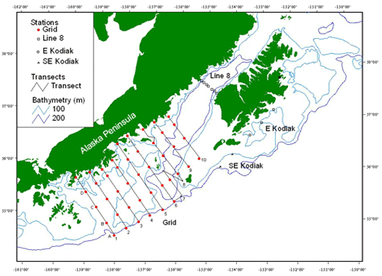
activities are included in Figure 1 and Table 3.
1.0. PERSONNEL
1.1. Chief Scientist:
Matt Wilson, M/AFSC
206-526-6522
Matt.Wilson@NOAA.gov
The Chief Scientist has the authority to
revise or alter the technical portion of the instructions as work progresses
provided that, after consultation with the Commanding Officer, it is ascertained
that the proposed changes will not: (1) jeopardize the safety of personnel
or the ship; (2) exceed the overall time allotted for the project; (3)
result in undue additional expenses; (4) alter the general intent of these
project instructions.
1.2 Participating Scientists:
Morgan Busby, M/AFSC
Rachel Cartwright, F/AFSC
Jay Clark M/AFSC
Frank Morado M/AFSC
Steve Porter M/AFSC
Bill Rugen M/AFSC
Janet Duffy-Anderson F/JISAO
Sonia Hamilton F/PMEL
1.3 NOAA Marine Operations Center, Pacific
Contact:
Larry Mordock
NOAA/MOP (MOP1x4)
1801 Fairview Ave. East
Seattle, WA 98102-3767
(206) 553 - 4764
Larry.Mordock@noaa.gov
1.4 Program Contacts:
Dr. Phyllis Stabeno
PMEL
7600 Sand Point Way NE
Seattle, WA 98115-6349
(206) 526-6453
Phyllis.Stabeno@noaa.gov
Dr. Art Kendall
AFSC
7600 Sand Point Way NE
Seattle, WA 98115-6349
(206) 526-4108
2.0. OPERATIONS
A standard oceanographic watch
will be utilized which consists of a winch operator, a scientific staff
of four and a Survey Tech on deck. Because this cruise involves much fishing
with otter trawls, a fishing crew will also be necessary. Operations will
be conducted 24 hours a day.
2.1. SUMMARY OF ACTIVITIES:
This study will focus mainly on
a grid of stations over the shelf and nearshore areas between Kodiak and
the Shumagin Islands (Figure 1). About 760 nmi of acoustic tracklines (plus
150 nmi between lines) and 43 trawl stations will be occupied. Some modification
of station location may be needed to avoid unnavigable areas. Sampling
will commence at the southern-most station on Line 1, approximately 1.25
d from Kodiak. Enroute to the study area, a CTD cast will be conducted
to calibrate the Sea-Cat, micro-bathythermographs (MBT), and Scanmar
(or NetMind) depth sensor. A couple more calibrations will be conducted
while sampling the main station grid. Nighttime sampling at all stations
and acoustic transects will be used to address the primary cruise objective;
the secondary objective will be addressed by comparing nighttime samples
with daytime samples collected at as many stations and transect segments
as possible.
Night or day, the same procedure will be
used to sample with nets at each grid station. The first operation at each
station will always be to collect a plankton sample. This will be accomplished
with a 1-m Tucker trawl to provide additional information on the vertical
distribution of plankters. The second operation at each station will be
to collect age-0 pollock with double oblique tows (surface to near bottom
to surface) of the anchovy trawl. Night or day, acoustic data will
be collected at each station and while underway. Backscatter and target
strength data will be collected with the MACE groups EK-500 echo sounder
(38 and 120 kHz) continuously for the cruise duration, including the transits
between Kodiak and the study area. Continuous monitoring of the acoustic
system will require the dedication of one person per shift. Each of the
nine transects will be run at 12 kts. Slower speed may be necessary for
safe navigation near shallows. Most transects are 15 nmi apart and each
varies in length from about 60 to 90 nmi long. Depth-targeted fishing (Tucker
and trawl) may be requested at places other than the predetermined stations
to improve the utility of the acoustic data. Two anchovy and two high-opening
shrimp trawls (61 headrope and footrope) will be available for targeted
fishing in midwater and on bottom, respectively. Both trawls are fished
with 5x7 steel-V doors, and both will have 1/8" (3mm) codend liners.
A gear comparison experiment will be conducted
at night consisting of five Methot tows at five different grid stations
where at least 1,000 age-0 pollock are collected in the anchovy trawl.
Age-0 pollock density and size estimates will be compared. Each net will
be fished obliquely (surface-bottom-surface). Methot net depth will be
monitored with Scanmar (real time, no data record) and a micro-bathythermograph
(MBT, data record).
2.2 PROCEDURES FOR OPERATIONS:
The following operations will
be conducted on this cruise. Supplementary instructions for these operations
are listed in the FOCI Standard Operating Instructions (SOI):
CTD/Water samples (SOI 2.2.1)
MARMAP bongo tow (SOI 2.2.2)
Methot trawl (SOI 2.2.7)
Midwater trawl (SOI 2.2.8)
Tucker trawl (SOI 2.2.9)
EK500 monitoring (SOI 2.2.12)
The Tucker trawl will be fished obliquely
from 200 m or 10 m off bottom, whichever is shallowest, to the surface.
Real time depth of the trawl will be determined using the Sea-Cat, which
will also be used to record temperature and salinity profiles. A codend
may be put on the drogue to provide a quantitative sample of the zooplankton
from the surface to near bottom with a 505-um mesh net. Nets 1 and 2 will
be 333-um mesh. Net 1 will be fished from the maximum depth to the lower
edge of the thermocline as determined during the downcast; if no thermocline,
Net 1 will be closed at 40 m from the surface. Net 2 will be fished to
the surface. Adding the catch in Net 1 and 2 will provide a quantitative
estimate of zooplankton from the surface to near bottom. Except for large
jellyfish, the entire catch will be preserved in 5% formalin, large jellyfish
will be counted, weighed (as a group) and discarded. A second Tucker trawl
will be aboard as backup.
The anchovy trawl will be fished obliquely
from 200 m or 10 m off bottom, whichever is shallowest, to the surface.
This allows station-to-station comparison without the additional complication
of depth-targeted sampling. The remainder of this paragraph details how
the catch is to be processed. Age-0 pollock are the highest priority for
catch processing but data on other taxa will also be collected. Invertebrates
will be sorted to broad taxonomic categories: jellyfish (count and weigh),
invertebrate plankton (weigh and note approximate percentage of the volume
occupied by dominant constituents (eg., 75% euphausiid, 20% amphipod, 5%
pteropod)), and shrimps (count and weigh). Non-gadid fishes will be sorted
to the lowest taxonomic level that is easily possible. Cottids, agonids,
salmonids, and myctophids need no further identification. Smelts and flatfishes
must all be to species except for northern and southern rocksole, which
can be grouped as rocksole, and arrowtooth flounder, Kamchatka flounder,
and Greenland turbot, which can be grouped as AKG complex. All individuals
of each group must be weighed. Individuals within each group must also
be counted and their lengths measured, this may be accomplished by taking
a representative subsample. Gadid fishes must be counted and weighed by
species. It may be necessary to treat juvenile individuals of a species
separate from the adults. All individuals, or a representative subsample,
of each group must be lengthed. For age-0 pollock, about 200 fish is the
desired number of fish to measure. High priority is placed on getting two
randomly selected subsamples of age-0 pollock preserved as quickly as possible
after the catch has been dumped onto the sorting table. One subsample of
about 50 fish is to be frozen (-20o F, slime lab freezer) (length-weight,
otolith), the other will be preserved in 10% formalin (individuals larger
than about 60 mm SL must have the body cavity carefully punctured DO
NOT PIERCE THE GUT) (length-weight, diet). Five individuals within each
subsample will be selected by relative size, and placed on ice while their
individual length and weight is measured (shrinkage control). The number
of fish comprising each subsample must be accurately recorded (eg., 49
fish froz.; 63 fish form.). If fewer than 100 fish are collected, freeze
up to 50, and preserve the remainder in formalin.
The EK-500 (38 and 120 kHz) acoustic system
will be continuously monitored in the study area as well as enroute to
and from the area. Markers will be placed on the echograms and in the acoustic
data using the Bergen Integrator, and entered in the EK-500 logbook (eg.,
Start transect, Break transect (at station #, or transit to next transect),
Begin net tow (Tucker, =surface; Trawl, =doors away), At depth, End net
tow (Tucker, =surface; Trawl, =doors back), Resume transect). The echo
sounder will not be calibrated during this cruise, but a calibration will
be done just prior to it. As mentioned previously, depth-targeted fishing
(plankton and trawl gear) may be requested at places other than the predetermined
stations to improve the utility of the acoustic data.
3.0. FACILITIES AND EQUIPMENT
The following systems and their
associated support services are essential to the cruise. Sufficient consumables,
back-up units, and on-site spares and technical support must be in place
to assure that operational interruptions are minimal. All measurement instruments
are expected to have current calibrations, and all pertinent calibration
information shall be included in the data package. Much of the equipment
to be provided by the project was loaded aboard for previous cruises. Some
gear, including the two shrimp trawls and Scanmar equipment, will be loaded
in Dutch Harbor on August 3 by ship personnel. The remaining gear (including
two anchovy trawls, 5x7 doors, Tucker trawl, Sameoto neuston net, jars)
will be shipped from Seattle on August 17 and loaded in Kodiak on September
1 or 2.
3.1 Equipment and Capabilities to be Provided
by the Ship
 |
Oceanographic winch with slip rings and 3-conductor
cable terminated for CTD |
|
Wire-angle indicator and readout for oceanographic
winch |
|
Oceanographic winch for Tucker net (and other
nets when used) with slip rings and 3-conductor cable terminated for the
SeaCat |
|
Sea-Bird 911 plus CTD system to be used with
PMEL stand (primary system) (The underwater CTD unit should have mounts
compatible with the PMEL CTD stand) |
|
Sea-Bird 911 plus CTD system with stand (back
up system, incomplete set of back-up sensors) |
(Each CTD system should include underwater
CTD, weights, and pinger and there should be one deck unit and tape recorder
for the two systems)
|
For CTD field corrections: AUTOSAL salinometer |
|
Sea-Bird SBE-19 Seacat system (primary system,
no back up) |
|
Meter block for plankton tows |
|
Wire speed indicators and readout for quarterdeck,
Rowe and Marco winches |
|
For meteorological observations: 2 anemometers
(one R. M. Young system interfaced to the SCS) calibrated air thermometer
(wet-and dry-bulb) and a calibrated barometer and/or barograph |
|
Freezer space for storage of biological and
chemical samples (blast and storage freezers) |
|
Furuno or other to indicate gear depth of
otter trawls |
|
Simrad EQ-50 echo sounder |
|
JRC JFV-200R color sounder recorder |
|
RDI ADCP written to Iomega Zip drives |
|
Use of Pentium PC in DataPlot for data analysis |
|
SCS (Shipboard Computer System) |
|
Stern platform removed for trawl and Methot
tows |
|
Laboratory space with exhaust hood, sink,
lab tables and storage space |
|
Sea-water hoses and nozzles to wash nets (quarterdeck
and aft deck) |
|
Adequate deck lighting for night-time operations |
|
Navigational equipment including GPS and radar |
|
Safety harnesses for working on quarterdeck
and fantail |
|
Sorting table for fish catch |
|
Dynanomometer |
3.2 Equipment to be Provided by the Project
Physical Sampler
|
Micro-bathythermograph (four MBTs) |
Biological Samplers
|
1-m Tucker trawl (and backup) and accessories |
|
20-cm bongo net and accessories |
|
60-cm bongo net and accessories |
|
Methot trawl (and backup) |
|
ScanMar depth sensor system |
|
NetMind depth sensor system |
Otter trawls
|
Anchovy trawl (and backup) |
|
High-opening shrimp trawl (and backup) |
|
Two 5x7 steel-V doors (1,250 lbs each) |
|
Dandylines and pucker strings for all trawls |
|
Spare web for all trawls |
|
Simrad EK-500 (38 & 120 kHz) acoustic
system (MACEs system) |
|
Four HP-855C single-sheet printers |
|
Printer paper |
|
Printer cartridges (tentatively, 1 color per
d and 1 b/w per 2 d) |
|
Data storage tapes and optical disks |
|
Miscellaneous Sampling and Processing Equipment |
|
9 flowmeters, calibration data, hardware for
attaching and maintaining them |
|
Fish baskets, dishpans, 5-gal buckets, and
wading pool |
|
Length board and strips for adult fish |
|
Length board for age-0 fish |
|
Mechanical and Marel platform scales for catch
weights |
|
Sartorius scale for individual fish weights |
|
Sieves, jar holder, funnels, squirt bottles |
|
Haul and catch forms for anchovy trawls, and
DSDB for all other operations |
|
400 32-oz jars, closures, and labels (grid:
anchovy, 86; Methot, 10; Tucker, 172; extra, 132) |
|
200 Zip-loc bags (12") |
|
Scalpel and scalpel blade (for body cavity
incisions) |
|
Preservatives and dispenser equipment |
|
Hazardous materials spill kit |
|
Miscellaneous bookkeeping equipment/supplies |
|
Spare wire angle indicator |
Bookkeeping
|
Binders and folders |
|
3-ring hole punch |
|
Scientific ultra-cold freezer |
3.3. Ship's Computer System (SCS)
The ship's Scientific Computer
System (SCS) shall operate throughout the cruise, acquiring and logging
data from navigation, meteorological, oceanographic, and fisheries sensors.
See FOCI Standard Operating Instructions for specific requirements. Need
1 min averaged time, position, T, S, water depth, and insolation in ASCII
format.
4.0 DATA AND REPORTS
Data disposition, responsibilities
and data requirements are listed in the FOCI Standard Operating Instructions.
5.0 ADDITIONAL INVESTIGATIONS AND PROJECTS
5.3 Piggyback projects:
None at this time.
6.0 MISCELLANEOUS
6.5. Hazardous Materials:
The Chief Scientist shall be responsible
for complying with NC Instruction 6280A, Hazardous Waste; policy, guidance,
and training, dated February 4, 1991, paragraph 7.g and paragraph 9. By
federal law, the ship may not sail without a complete inventory of MSDS,
and appropriate neutralizing agents, buffers, and/or absorbents in amounts
adequate to address spills of a size equal to the amount aboard.
The following hazardous materials will
be provided and controlled by the scientists with the Chief Scientist assuming
responsibility for the safe handling of such substances:
5 gallons of 37% Formalin
7.0 COMMUNICATIONS
7.4 Important phone numbers, fax numbers
and e-mail addresses:
PMEL/CARD Fax: (206) 526-6485
PMEL/ADMIN Fax: (206) 526-6815
AFSC/RACE Fax: (206) 526-6723
MILLER FREEMAN COMSAT (government account
numbers): These are much cheaper than Inmarsat direct numbers and should
always be used first.
800-678-0872, after voice prompt
dial 330-394-113, after tone dial customer ID# (Voice)
800-678-0872, after voice prompt dial
761-267-348, after tone dial customer ID# (Fax)
PIs should establish their ID#s with their
program.
Inmarsat (direct numbers)
011-872-330-394-113 (voice)
011-872-761-267-348 (fax)
CELLULAR: 206-660-7167
KODIAK ROAMER: 907-528-7626
DUTCH HARBOR ROAMER: 907-391-7626
(First dial the roamer, wait for dial
tone, and then dial cellular number.)
8.0. APPENDICES
Table 1. Grid transect locations
for Miller Freeman cruise MF00-11 (=FOCI 8MF00).
| |
N. Latitude |
W. Longitude |
N. Latitude |
W. Longitude |
Distance |
|
| Transect |
(dd) |
(mm.m) |
(dd) |
(mm.m) |
(dd.d) |
(dd.d) |
(nmi) |
Sampling |
| 1south |
54 |
41.0 |
158 |
3.2 |
54.683 |
158.053 |
80 |
EK-500 38 & 120 kHz |
| 1north |
55 |
44.4 |
159 |
28.6 |
55.740 |
159.477 |
|
EK-500 38 & 120 kHz |
| |
|
|
|
|
|
|
|
|
| 2s |
54 |
49.9 |
157 |
40.1 |
54.832 |
157.668 |
80 |
EK-500 38 & 120 kHz |
| 2n |
55 |
51.4 |
159 |
1.4 |
55.857 |
159.023 |
|
EK-500 38 & 120 kHz |
| |
|
|
|
|
|
|
|
|
| 3s |
54 |
58.1 |
157 |
16.2 |
54.968 |
157.270 |
76 |
EK-500 38 & 120 kHz |
| 3n |
55 |
56.0 |
158 |
36.1 |
55.933 |
158.602 |
|
EK-500 38 & 120 kHz |
| |
|
|
|
|
|
|
|
|
| 4s |
55 |
6.1 |
156 |
53.8 |
55.102 |
156.897 |
77 |
EK-500 38 & 120 kHz |
| 4n |
56 |
7.0 |
158 |
17.2 |
56.117 |
158.287 |
|
EK-500 38 & 120 kHz |
| |
|
|
|
|
|
|
|
|
| 5s |
55 |
13.1 |
156 |
29.0 |
55.218 |
156.483 |
92 |
EK-500 38 & 120 kHz |
| 5n |
56 |
26.4 |
158 |
8.4 |
56.440 |
158.140 |
|
EK-500 38 & 120 kHz |
| |
|
|
|
|
|
|
|
|
| 6s |
55 |
23.2 |
156 |
6.4 |
55.387 |
156.107 |
92 |
EK-500 38 & 120 kHz |
| 6n |
56 |
36.4 |
157 |
48.4 |
56.607 |
157.807 |
|
EK-500 38 & 120 kHz |
| |
|
|
|
|
|
|
|
|
| 7s |
55 |
30.0 |
155 |
51.5 |
55.500 |
155.858 |
35 |
EK-500 38 & 120 kHz |
| 7n |
55 |
58.2 |
156 |
30.3 |
55.970 |
156.505 |
25 |
EK-500 38 & 120 kHz |
| |
|
|
|
|
|
|
|
|
| 8s |
55 |
47.3 |
155 |
49.5 |
55.788 |
155.825 |
78 |
EK-500 38 & 120 kHz |
| 8n |
56 |
44.7 |
157 |
16.4 |
56.745 |
157.273 |
|
EK-500 38 & 120 kHz |
| |
|
|
|
|
|
|
|
|
| 9s |
56 |
3.6 |
155 |
38.7 |
56.060 |
155.645 |
64 |
EK-500 38 & 120 kHz |
| 9n |
56 |
53.7 |
156 |
53.6 |
56.895 |
156.893 |
|
EK-500 38 & 120 kHz |
| |
|
|
|
|
|
|
|
|
| 10s |
56 |
13.2 |
155 |
17.1 |
56.220 |
155.285 |
60 |
EK-500 38 & 120 kHz |
| 10n |
57 |
0.4 |
156 |
23.9 |
57.007 |
156.398 |
|
EK-500 38 & 120 kHz |
| |
|
|
|
|
|
|
759 |
|
Table 2. Grid station locations for Miller
Freeman cruise MF00-11 (=FOCI 8MF00).
| |
|
|
|
|
|
|
Linear |
|
| |
N. Latitude |
W. Longitude |
N. Latitude |
W. Longitude |
Dist. to Next |
|
| Location |
(dd) |
(mm.m) |
(dd) |
(mm.m) |
(dd.d) |
(dd.d) |
(nmi) |
Sampling |
| 1A |
54 |
41.0 |
158 |
3.2 |
54.683 |
158.053 |
17 |
Tuck1 & ANCH |
| 1B |
54 |
54.4 |
158 |
20.3 |
54.907 |
158.338 |
22 |
Tuck1 & ANCH |
| 1C |
55 |
12.2 |
158 |
42.6 |
55.203 |
158.710 |
21 |
Tuck1 & ANCH |
| 1D |
55 |
28.6 |
159 |
6.3 |
55.477 |
159.105 |
20 |
Tuck1 & ANCH |
| 1E |
55 |
44.4 |
159 |
28.6 |
55.740 |
159.477 |
17 |
Tuck1 & ANCH |
| 2E |
55 |
51.4 |
159 |
1.4 |
55.857 |
159.023 |
16 |
Tuck1 & ANCH |
| 2D |
55 |
39.5 |
158 |
46.1 |
55.658 |
158.768 |
23 |
Tuck1 & ANCH |
| 2C |
55 |
22.0 |
158 |
22.3 |
55.367 |
158.372 |
22 |
Tuck1 & ANCH |
| 2B |
55 |
5.1 |
157 |
59.6 |
55.085 |
157.993 |
20 |
Tuck1 & ANCH |
| 2A |
54 |
49.9 |
157 |
40.1 |
54.832 |
157.668 |
17 |
Tuck1 & ANCH |
| 3A |
54 |
58.1 |
157 |
16.2 |
54.968 |
157.270 |
21 |
Tuck1 & ANCH |
| 3B |
55 |
14.2 |
157 |
36.8 |
55.237 |
157.613 |
23 |
Tuck1 & ANCH |
| 3C |
55 |
31.8 |
158 |
1.8 |
55.530 |
158.030 |
21 |
Tuck1 & ANCH |
| 3D |
55 |
48.7 |
158 |
24.9 |
55.812 |
158.415 |
9 |
Tuck1 & ANCH |
| 3E |
55 |
56.0 |
158 |
36.1 |
55.933 |
158.602 |
16 |
Tuck1 & ANCH |
| 4E |
56 |
7.0 |
158 |
17.2 |
56.117 |
158.287 |
11 |
Tuck1 & ANCH |
| 4D |
55 |
59.4 |
158 |
5.4 |
55.990 |
158.090 |
22 |
Tuck1 & ANCH |
| 4C |
55 |
41.8 |
157 |
42.3 |
55.697 |
157.705 |
25 |
Tuck1 & ANCH |
| 4B |
55 |
22.9 |
157 |
16.1 |
55.382 |
157.268 |
20 |
Tuck1 & ANCH |
| 4A |
55 |
6.1 |
156 |
53.8 |
55.102 |
156.897 |
16 |
Tuck1 & ANCH |
| 5A |
55 |
13.1 |
156 |
29.0 |
55.218 |
156.483 |
24 |
Tuck1 & ANCH |
| 5B |
55 |
32.2 |
156 |
53.6 |
55.537 |
156.893 |
25 |
Tuck1 & ANCH |
| 5C |
55 |
52.4 |
157 |
21.0 |
55.873 |
157.350 |
22 |
Tuck1 & ANCH |
| 5D |
56 |
9.4 |
157 |
44.5 |
56.157 |
157.742 |
22 |
Tuck1 & ANCH |
| 5E |
56 |
26.4 |
158 |
8.4 |
56.440 |
158.140 |
17 |
Tuck1 & ANCH |
| 6E |
56 |
36.4 |
157 |
48.4 |
56.607 |
157.807 |
23 |
Tuck1 & ANCH |
| 6D |
56 |
19.1 |
157 |
24.6 |
56.318 |
157.410 |
22 |
Tuck1 & ANCH |
| 6C |
56 |
1.7 |
157 |
0.5 |
56.028 |
157.008 |
26 |
Tuck1 & ANCH |
| 6B |
55 |
41.1 |
156 |
32.0 |
55.685 |
156.533 |
22 |
Tuck1 & ANCH |
| 6A |
55 |
23.2 |
156 |
6.4 |
55.387 |
156.107 |
26 |
Tuck1 & ANCH |
| 7B |
55 |
48.2 |
156 |
16.4 |
55.803 |
156.273 |
12 |
Tuck1 & ANCH |
| 8B |
55 |
55.2 |
156 |
0.2 |
55.920 |
156.003 |
27 |
Tuck1 & ANCH |
| 8C |
56 |
15.5 |
156 |
32.0 |
56.258 |
156.533 |
19 |
Tuck1 & ANCH |
| 8D |
56 |
29.5 |
156 |
53.4 |
56.492 |
156.890 |
21 |
Tuck1 & ANCH |
| 8E |
56 |
44.7 |
157 |
16.4 |
56.745 |
157.273 |
15 |
Tuck1 & ANCH |
| 9E |
56 |
53.7 |
156 |
53.6 |
56.895 |
156.893 |
14 |
Tuck1 & ANCH |
| 9D |
56 |
42.1 |
156 |
36.2 |
56.702 |
156.603 |
21 |
Tuck1 & ANCH |
| 9C |
56 |
26.2 |
156 |
10.6 |
56.437 |
156.177 |
29 |
Tuck1 & ANCH |
| 9B |
56 |
3.6 |
155 |
38.7 |
56.060 |
155.645 |
16 |
Tuck1 & ANCH |
| 10B |
56 |
13.2 |
155 |
17.1 |
56.220 |
155.285 |
29 |
Tuck1 & ANCH |
| 10C |
56 |
36.3 |
155 |
49.0 |
56.605 |
155.817 |
20 |
Tuck1 & ANCH |
| 10D |
56 |
51.6 |
156 |
11.6 |
56.860 |
156.193 |
11 |
Tuck1 & ANCH |
| 10E |
57 |
0.4 |
156 |
23.9 |
57.007 |
156.398 |
|
Tuck1 & ANCH |
Table 3. Line 8, east Kodiak and southeast
Kodiak Island station locations for Miller Freeman cruise MF00-11 (=FOCI
8MF00).
| |
|
N. Latitude |
W. Longitude |
N. Latitude |
W. Longitude |
|
| Area |
Station |
(dd) |
(mm.m) |
(dd) |
(mm.m) |
(dd.d) |
(dd.d) |
Sampling |
| Line 8 |
FOX61 |
57 |
43.2 |
155 |
15.6 |
57.720 |
155.260 |
CTD |
| Line 8 |
FOX60 |
57 |
41.0 |
155 |
10.0 |
57.680 |
155.170 |
CTD |
| Line 8 |
FOX59 |
57 |
38.5 |
155 |
4.2 |
57.640 |
155.070 |
CTD |
| Line 8 |
FOX58 |
57 |
36.3 |
155 |
0.5 |
57.610 |
155.010 |
CTD |
| Line 8 |
FOX57 |
57 |
33.1 |
154 |
52.5 |
57.550 |
154.880 |
CTD |
| Line 8 |
FOX56 |
57 |
30.9 |
154 |
47.0 |
57.520 |
154.780 |
CTD |
| Line 8 |
FOX55 |
57 |
28.5 |
154 |
42.0 |
57.480 |
154.700 |
CTD |
| |
|
|
|
|
|
|
|
|
| SE Kodiak |
hl165 |
56 |
4.8 |
154 |
33.4 |
56.080 |
154.556 |
Neuston |
| SE Kodiak |
hl169 |
56 |
19.3 |
154 |
8.6 |
56.322 |
154.143 |
Neuston |
| |
|
|
|
|
|
|
|
|
| E Kodiak |
hl175 |
56 |
41.1 |
153 |
31.2 |
56.685 |
153.520 |
Anchovy |
| E Kodiak |
hl179 |
56 |
55.6 |
153 |
6.0 |
56.927 |
153.100 |
Anchovy |
| E Kodiak |
hl183 |
57 |
10.1 |
152 |
40.7 |
57.169 |
152.678 |
Anchovy |
Figure 1. Station and transect locations
|