What's New Archive
To collect consistent passive acoustic data simultaneously across all major regions of the US, NOAA and the National Park Service scientists have teamed up to create the Ocean Noise Reference Station Network (NRS).
Through vivid imagery and sound clips, NOAA's story map "Listening to the Sea" explores the NRS and its use of passive acoustic instruments to record sound in the ocean.
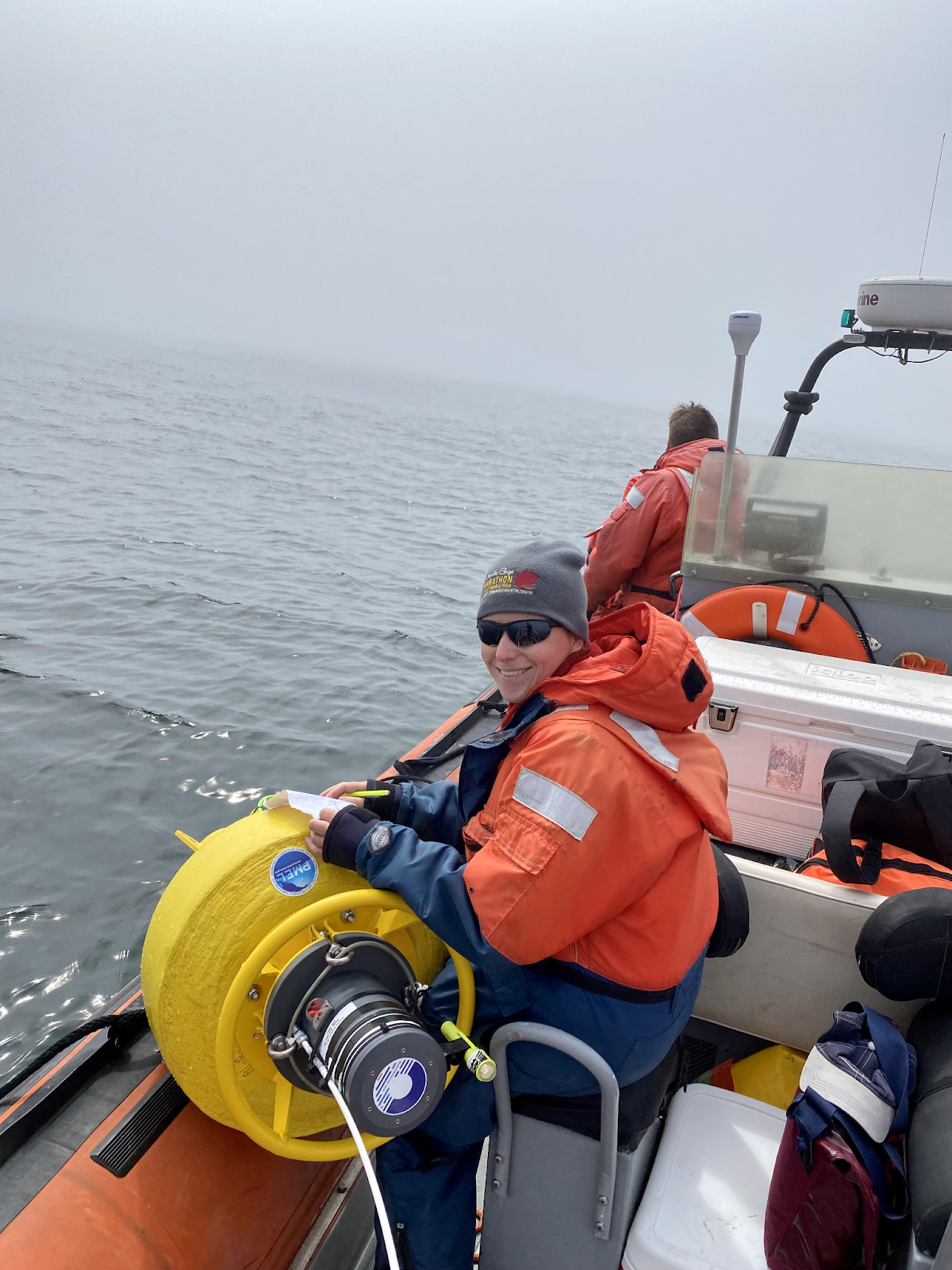
Reviewing checklist and final preparations to deploy drifting hydrophone buoys off the coast of Oregon.
A new video highlighting PMEL's acoustics research and eDNA innovations to study Blue Whales off the coast of Newport, Oregon has been released in the “PMEL at Work” YouTube series.
This video features PMEL’s Acoustic Program’s Bob Dziak and Angela Sremba discussing ongoing research to develop technology to better understand blue whales by simultaneously collecting environmental DNA (eDNA) samples and recording acoustic calls through deploying drifting buoys with underwater hydrophones.
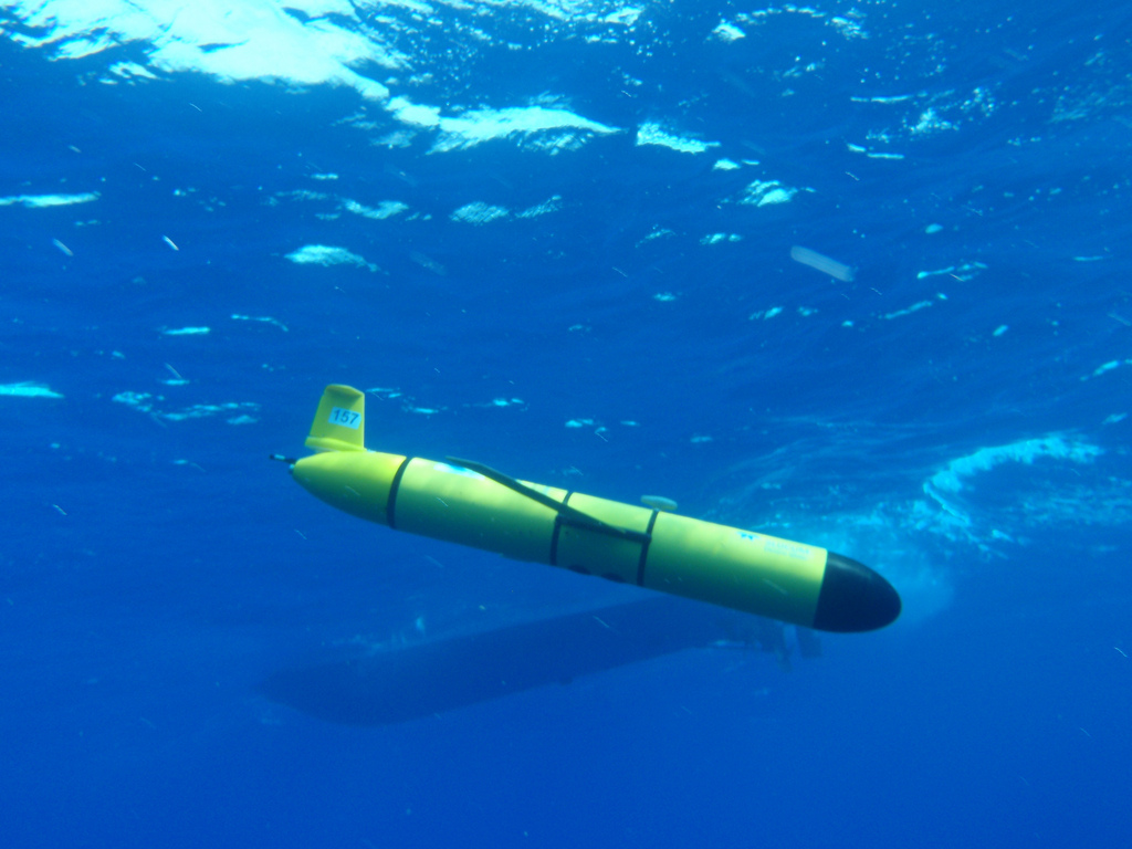
Over the summer of 2021, PMEL and OSU CIMERS scientists field tested three passive-acoustic hydrophones to identify and locate blue and fin whales. These new smart hydrophones have an internal microprocessor that communicates the location of the buoys to shore. PMEL developed software for the microprocessor that will analyze the hydrophone data using a blue whale call detection algorithm. The goal for this algorithm is to register a positive blue call detection and transmit this positive detection information, as well as the position of the buoy, via satellite communication to shore to let scientists know when and where a blue whale call is recorded. When a call is detected on multiple buoys, the shore based scientists can then determine the location of the calling whale, and then inform the ship’s crew that a blue whale is nearby. The location of the whale will be correlated with the results from collected eDNA samples.
This past summer was a successful field test of the hydrophone buoys in anticipation for upcoming fieldwork in the summer of 2022 where PMEL will simultaneously collect acoustic recordings and eDNA samples of blue whales off the Oregon coast. This project will improve interpretation of eDNA results by using a time-series sampling method combined with acoustic detection for tracking and localizing highly migratory whale species in remote open ocean habitats.
This is a collaborative project between Oregon State University Marine Mammal Institute and Cooperative Institute for Marine Ecosystem and Resources Studies (CIMERS) and NOAA.
The PMEL at Work video series highlights ongoing research activities and projects supporting NOAA’s mission to understand changes in the global ocean and its impact on climate, weather and ecosystems.
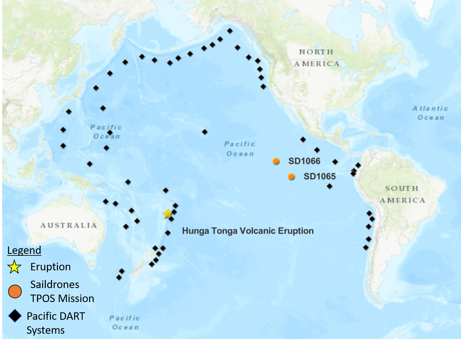
Map of the tropical Pacific showing the positions of DART buoys operated by NOAA and international partners as well as saildrone 1065 and 1066 relative to the Hunga Ha’apai Volcano located in the Pacific island nation of Tonga, which is an archipelago consisting of more than 170 islands.
On January 15, 2022, the Hunga Tonga-Hunga Ha’apai volcano erupted off the coast of Tonga in the South Pacific Ocean, generating a tsunami and triggering tsunami alerts around the world. Most tsunamis are commonly caused by earthquakes and only about 5% of tsunamis are generated from volcanic activity (ITIC), making this a rare event captured by NOAA’s observing instruments.
Buoys and Saildrone uncrewed surface vehicles additionally recorded an air pressure wave associated from the eruption. The pressure wave from the volcano explosion was detected as far as the Mediterranean Sea and traveled about 312 meters/second (697 miles per hour) and circled the Earth three times before dissipating. The Krakatau eruption in 1883 was the last event of such scale. Krakatau produced similar air pressure waves and a devastating tsunami that claimed the lives of ~36,000 people and the destruction of hundreds of coastal towns and villages.
Deep-ocean Assessment and Reporting of Tsunamis (DART) systems are strategically deployed by NOAA and international partners around the Pacific Ocean to detect tsunami waves and send data in realtime to tsunami warning centers. These systems recorded the propagating tsunami across the Pacific and prompted expansion of the tsunami alerts for many coastlines in the Pacific. Those warnings may have saved lives at many coastlines that were later flooded by the waves, some as far as the Pacific coast of Peru.
Along with the tsunami wave amplitudes measured by the DART system, the atmospheric pressure wave associated with a shock-wave emanating from the volcano explosion was measured. The air pressure signal detected by weather station buoys is the leading signature before the tsunami wave train and may provide clues for the mechanism of this unusual tsunami generation. However, given that the pressure signal mixed with the tsunami amplitudes in the data, high-resolution air pressure measurements are needed to decipher the DART tsunami records.
Coincidentally, two NOAA-Saildrone drones were approximately 3500 nautical miles (~4028 miles) away from the eruption, the distance to drive between Anchorage, Alaska and Miami, Florida, in the eastern tropical Pacific Ocean. The two drones are part of a 6-month, ongoing Tropical Pacific Observing System (TPOS) mission targeting the eastern tropical Pacific hurricane genesis region and El Niño Southern Oscillation (ENSO) development. The two drones were able to detect an atmospheric pressure jump in high-resolution measurements, capturing crucial information associated with the remote volcanic activity in an observationally-sparse region of the ocean for post-analysis with the DART tsunami records.
The phenomena recorded in the data is unique and additional research and development is needed to accommodate these types of tsunami events in the model used to forecast tsunami events. PMEL tsunami researchers are analyzing the data from the various platforms to get a better understanding of this rare event.
PMEL has also previously studied the dynamics of a smaller scale eruptive activity of this volcano using acoustic data and will uncover and analyze additional acoustic data from hydrophones deployed across the Pacific when they are recovered later this year.
Read more on the TPOS 2021 Saildrone Mission on the blog page.
More about the event can be found on the PMEL Tsunami Research group events page.
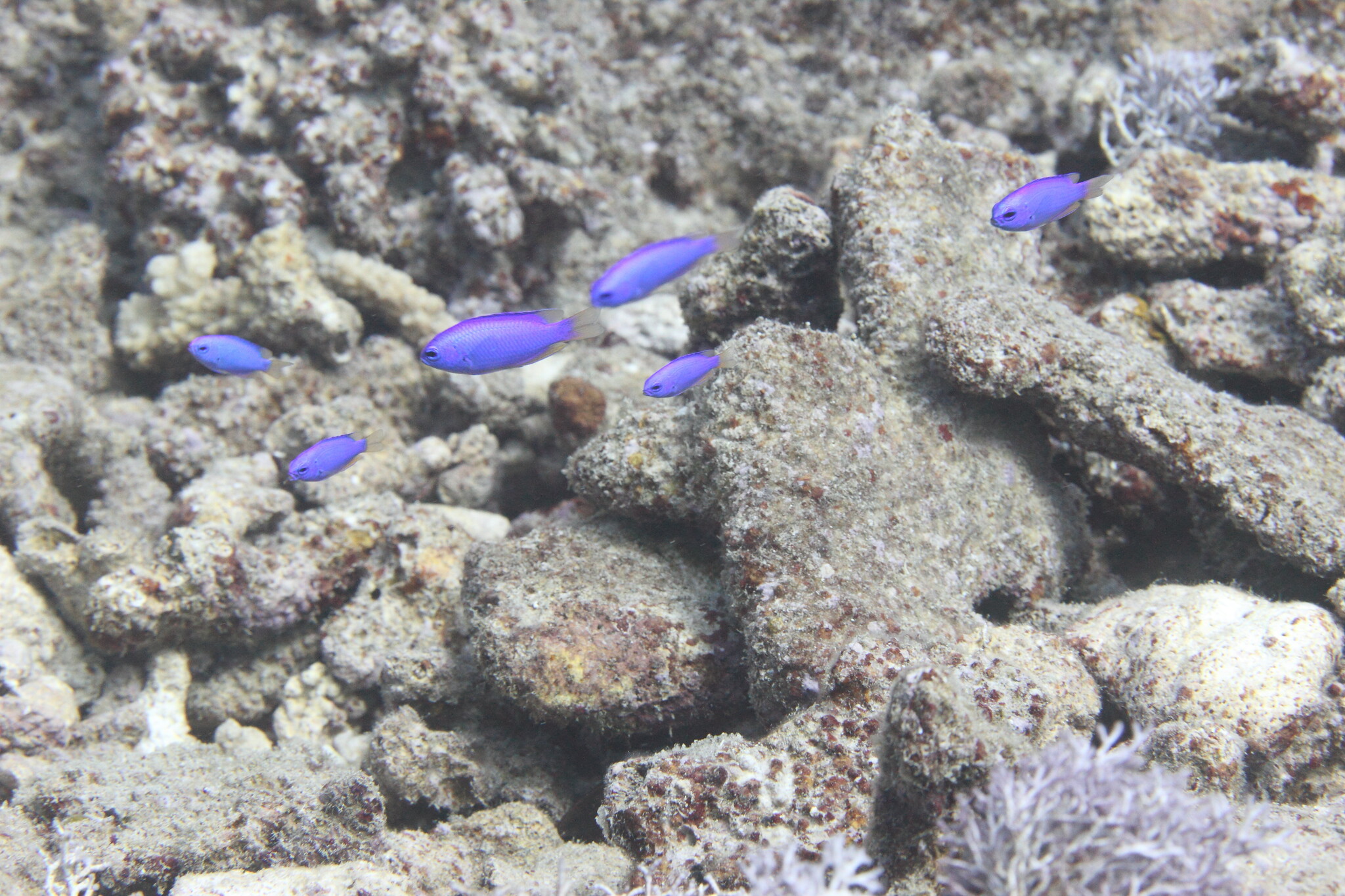
Damselfish in a tropical reef region within the National Park of American Samoa. Photo Credit National Park System. Click here to listen to a recording of damselfish.
A research team led by NOAA’s Cooperative Institute for Marine Ecosystem and Resource Studies at Oregon State University has developed an automated method that can accurately identify calls from a family of fishes.
The method takes advantage of data collected by underwater microphones known as hydrophones and provides an efficient and inexpensive way to understand changes in the marine environment due to climate change and other human-caused influences, said researchers from Oregon State’s Cooperative Institute for Marine Ecosystem and Resource Studies.
The findings were published in the journal Marine Ecology Progress Series.
Hydrophones are increasingly being deployed in the world’s oceans. They offer advantages over other types of monitoring because they work at night, in low-visibility conditions and over long periods of time. But techniques to efficiently analyze data from hydrophones are not well developed.
This new research led by Jill Munger when she was an undergraduate student, begins to change that. Munger came to Oregon State having worked more than 20 years in the corporate world. An avid scuba diver, she wanted to study the ocean. She received a fellowship from CIMERS to research underwater acoustics with Joe Haxel, who at the time was at the Hatfield Marine Science Center in Newport working with National Oceanic and Atmospheric Administration’s Pacific Marine Environmental Lab’s acoustic program.
Haxel handed her a hard drive with 18,000 hours of acoustic data collected over 39 months in a tropical reef region within the National Park of American Samoa. American Samoa is a U.S. territory in the western Pacific Ocean.
The data was collected via a 12-station hydrophone array maintained by NOAA and the National Park Service that is distributed throughout the world in water controlled by the United States. The hydrophones were designed and built by NOAA and CIMERS researchers at Hatfield Marine Science Center.
Munger decided to focus on calls from damselfish, in part, because they are distinctive. They grind their teeth to create pops, clicks and chirps associated with aggressive behavior and nest defense. She compared the sound to purring kittens. Quickly, it became apparent to her that manually listening to the recordings was not going to work.
“This is such a slow and tedious process,” she remembered thinking. “I have all this data, and I am just looking at a tiny, tiny portion of it. What’s happening in all the other parts that I haven’t had a chance to listen to?”
A conversation with her brother, Daniel Herrera, a machine learning engineer, sparked an idea. Could they use machine learning to automate the analysis of the data?
Machine learning algorithms build a model based on sample data, known as training data, to make predictions or decisions without being explicitly programmed to do so.
Machine learning techniques have been used to automate processing of large amounts of data from passive acoustic monitoring devices that collected sound data from birds, bats and marine mammals. The techniques have been used for fish calls, but it is an underdeveloped area of science, Munger said.
In this case, the machine learning sample or training data was 400 to 500 damselfish calls Munger identified by manually listening to the hydrophone recordings. With that start, Herrera, a co-author of the paper, built a machine learning model that accurately identified 94% of damselfish calls.
“We built a machine learning model on a relatively small set of training data and then applied it to an enormous set of data,” Munger said. “The implications for monitoring the environment are huge.”
Munger, who now works in the lab of Scott Heppell, an associate professor in Oregon State’s Department of Fisheries, Wildlife, and Conservation Sciences in the College of Agricultural Sciences, believes machine learning will increasingly be used by scientists to monitor many species of fish in the ocean because it requires relatively little effort.
“The benefit to observing fish calls over a long period of time is that we can start to understand how it’s related to changing ocean conditions, which influence our nation’s living marine resources,” Munger said. “For example, damselfish call abundance can be an indicator of coral reef health.”
Munger received input from National Park Service staff on the biology of the damselfish and the reef habitats in close proximity to the hydrophone.
Other co-authors of the paper are Haxel, Heppell, and Samara Haver, all of Oregon State; Lynn Waterhouse, formerly of John G. Shedd Aquarium in Chicago; Megan McKenna, formerly of Natural Sounds and Night Skies Division, National Park Service, Fort Collins, Colorado; and Jason Gedamke and Robert Dziak of NOAA’s Office of Science and Technology, Silver Spring, Maryland, and Pacific Marine Environmental Laboratory, Newport, respectively.
The following article was written by Sean Nealon at Oregon State University and adapted for NOAA PMEL. The Oregon State University news release is available online.
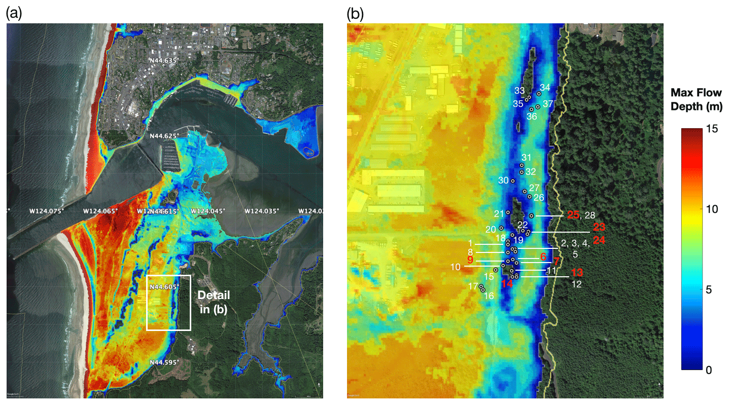
The left panel shows the model of maximum tsunami inundation depth at South Beach for the 1700 CE event and on the right a zoomed-in view of the tsunami inundation depth at Mike Miller State Park. Gray dotted circles show location of trees used in this study on the north side of the stand. Colors on the map show inundation depth from the model, implying 0–10 m of inundation depth at the Mike Miller Park Douglas-fir stand. Green areas are high ground locations that show no inundation. Dziak et al. 2021
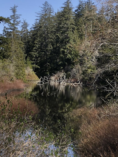
A stand of old growth Douglas-firs near a pond in Mike Miller Park in South Beach, Oregon
Core samples taken from a stand of old growth Douglas-fir trees in the South Beach area just south of Newport showed reduced growth following the 9.0 earthquake and subsequent tsunami that struck the Pacific Northwest in 1700.
The physical evidence from the Douglas-fir tree rings confirms modeling that depicts the reach of the January 1700 quake, which was the last major earthquake to hit the Cascadia Subduction Zone, said Robert Dziak, NOAA PMEL Acoustic Program lead.
“The tsunami appears to be the event that most affected the trees’ growth that year,” said Dziak, whose work includes ocean acoustic studies, signal analysis and tsunami modeling. He also holds a courtesy appointment in Oregon State University’s College of Earth, Ocean, and Atmospheric Sciences. “Getting these little bits of the picture helps us understand what we might expect when the next ‘big one’ hits.”
The findings were published recently in the journal Natural Hazards and Earth System Sciences.
The idea for the study dates back more than a decade; Dziak was aware of past research that had shown evidence of the 1700 quake in trees in Washington, and thought it might be worth seeing if similar evidence existed in Oregon.
The first challenge was finding a stand of old growth Douglas-firs in the tsunami inundation zone. The researchers looked at a few places before locating the stand in Mike Miller Park in South Beach, about two kilometers south of Yaquina Bay and 1.2 kilometers east of the present-day ocean shoreline.
“We’re not sure why this tree stand wasn’t logged over the years, but we’re very fortunate to have a site so close to the coastline that has survived,” said coauthor Bryan Black of the Laboratory of Tree-Ring Research at the University of Arizona, Tucson.
A new and updated tsunami model run by the researchers as part of the study shows that the area could have been inundated by up to 10 meters of water in the 1700 tsunami event, said Dziak.
Once the old growth stand was identified, the researchers collected core samples from about 38 trees using a process that allows them to analyze the tree rings without damaging the overall health of the trees. The majority of the trees dated to around 1670, with one dating to 1650, Dziak said.
They analyzed the growth rates in the rings and compared the growth rates to those of other old-growth Douglas-firs at sites not in the tsunami inundation zone. They found that in 1700 the trees in the tsunami inundation zone showed a significantly reduced growth rate.
Researchers are still working to figure out why the tsunami might have affected the trees’ growth since the trees are relatively far from the shoreline. They suspect it may be a combination of the ground shaking from the earthquake and the inundation of seawater.
“The salty seawater from a tsunami typically drains pretty quickly, but there is a pond area in Mike Miller Park where the seawater likely settled and remained for a longer period of time,” Dziak said.
Black added that the researchers’ next step is to conduct an isotopic analysis on the wood from 1700.
“We will look for signatures consistent with those found in trees that were inundated by the 2011 Tohoku tsunami in Japan,” he said. “If successful, we could develop a powerful new technique to map prehistoric tsunami run-up along the Pacific Northwest coast.”
Yong Wei of the University of Washington Cooperative Institute for Climate, Ocean and Ecosystem Studies and Susan Merle of the Cooperative Institute for Marine Resource Studies at Oregon State University’s Hatfield Marine Science Center are co-authors.
Originally posted on OSU News on August 24, 2021
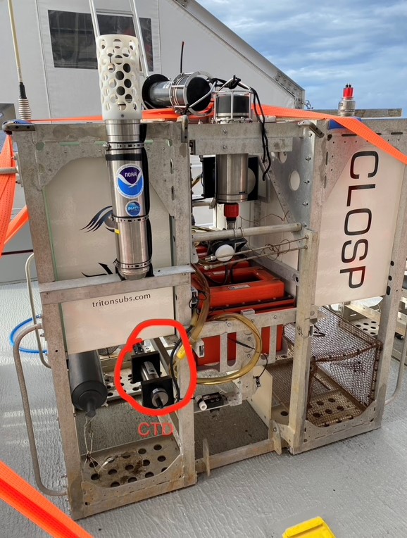
The full-ocean depth hydrophone (top left) attached to the CLOSP lander along with a conductivity, temperature and depth sensor (CTD). The lander also stores geological and biological samples collected by the submersible. Photo Credit: Kathy Sullivan/Caladan Oceanic
PMEL Acoustics Program and Engineering Development Division participated as part of a memorandum of understanding between NOAA and Caladan providing subject matter expertise on pressure sensors and acoustics during the June mission in the Mariana Trench to map the Challenger Deep with pressure sensors and collect oceanographic data. A full-ocean depth hydrophone was deployed during the Ring of Fire Expedition at Challenger Deep. The hydrophone was deployed on a lander with several deep-ocean pressure sensors over two cruises in the Challenger Deep basin. In addition, water samples for environmental DNA analysis have also been collected.
The first dive was completed on June 8 by Kathy Sullivan and Victor Vescovo aboard the Limiting Factor, a two-person submersible built by Triton Submarines and Caladan Oceanic. The recordings from the hydrophone are also part of acoustics research conducted by Woods Hole Oceanographic Institution to determine how sound waves propagate in the deepest parts of the ocean.
PMEL successfully first deployed the hydrophone in 2015 to establish a baseline for noise in the ocean’s deepest location. The recordings captured a baleen whale’s call, a magnitude 5.0 earthquake, an overhead typhoon and ship traffic noise.
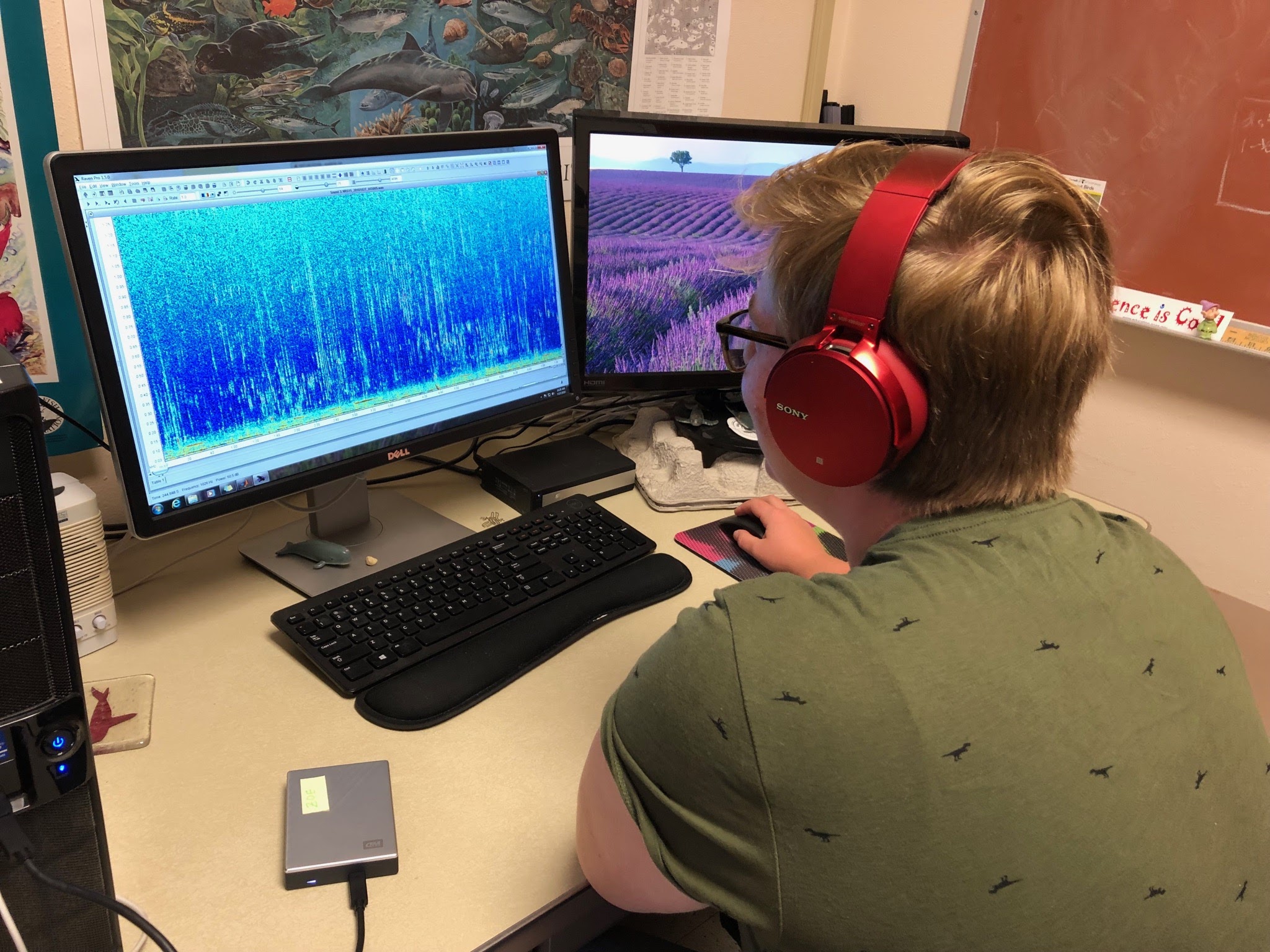
Zoe Rand, currently a master’s student at St. Andrews University, analyzing acoustic data last summer. Zoe was working with Samara Haver and the PMEL Acoustics Program in Newport to analyze whale vocalizations in Cordell Bank National Marine Sanctuary. Photo Credit: Samara Haver (OSU/NOAA PMEL).
The coronavirus pandemic response has reduced pollution from a large number of sources across many geographic regions. NOAA has launched a wide-ranging research effort to investigate the impact of reduced vehicle traffic, air travel, shipping, manufacturing, and other activities on Earth's atmosphere and oceans. Researchers are using the most advanced atmosphere-ocean models to look for changes in atmospheric composition, weather, climate, and precipitation over weeks to months. In the oceans, NOAA scientists will be assessing impacts of reduced underwater noise levels on marine life.
PMEL along with NOAA Fisheries Office of Science and Technology, NOAA Sanctuaries and Department of Interior’s National Park Service are collaborating to analyze data from hydrophones deployed around the United States coastal waters to measure changes and assess any impacts on fisheries and marine mammal activity due to reduced maritime transportation and other maritime activities.
Read the full story from NOAA Research.

41 scientists from PMEL, including scientists from NOAA's cooperative institutes at the University of Washington's Joint Institute for the Study of the Ocean and Atmosphere (JISAO) and Oregon State University's Cooperative Institute for Marine Resources Studies (CIMRS), the National Research Council, graduate and undergraduate students are heading to the Ocean Sciences Meeting in San Diego to share their current research. Talks and posters cover a range of topics include saildrone research, ocean observing systems, marine heatwaves, Arctic, acoustics, Deep Argo, genetics and genomics, El Nino, hydrothermal vents, methane, nutrients, technologies, ocean carbon and data management.
The 2020 Oceans Science Meeting is the flagship conference for the ocean sciences and the larger ocean-connected community. As we approach the UN Decade of Ocean Science for Sustainable Development, beginning in 2021, it is increasingly important to gather as a scientific community to raise awareness of the truly global dimension of the ocean, address environmental challenges, and set forth on a path towards a resilient planet. The meeting is co-sponsored by the American Geophysical Union (AGU), the Association for the Sciences of Limnology and Oceanography (ASLO), and The Oceanography Society (TOS).
PMEL research groups that will be present at the conference are: Acoustics, Arctic including Innovative Technology for Arctic Exploration, Climate-Weather Interface, Earth-Ocean Interactions, EcoFOCI, Engineering, Genetics and Genomics, Global Tropical Moored Buoy Array, , Large Scale Ocean Physics, Ocean Carbon, Ocean Climate Stations, Pacific Western Boundary Currents, and Science Data Integration Group.
Ocean gliders are a quiet and efficient mobile autonomous platform for passive acoustic monitoring and oceanographic measurements in remote marine environments. Researchers equipped a Teledyne Webb Research Slocum glider with a hydrophone to record sound along the US Pacific Northwest coast.
NOAA and Oregon State University researchers have developed an effective method to use an underwater robotic glider to measure sound levels over broad areas of the ocean, published today in the journal PLOS ONE.
“Healthy marine ecosystems need to have noise levels within particular ranges,” said Joe Haxel, lead author of the paper and assistant professor/senior research at Oregon State University and part of NOAA’s Pacific Marine Environmental Lab Acoustics Program. “As an analogy for humans it’s the difference between living in the country or living in the city or somewhere really loud.”
Ocean sound was recently listed as an essential ocean variable by the Global Ocean Observing System, a UNESCO program, due to its importance for marine life and seagoing humans and because it is used to monitor and locate everything from earthquakes to tsunamis to nuclear explosions.
Traditionally, scientists have measured ocean sound by attaching hydrophones, essentially an underwater microphone, to a fixed mooring in the water. The problem with that is scientists only get data from that single location. Ocean sound can also be measured from a research ship, but they are expensive to operate. They also create a lot of noise themselves, which disturbs marine animals and fish that are sensitive to sound.
Attaching a hydrophone to a glider solves those problems because gliders operate autonomously, relatively quietly and can cover hundreds of miles over several weeks.
Gliders equipped with hydrophones can conduct repeated surveys of a region of concern for acoustic habitat degradation and provide real-time measurements of changing noise levels. Gliders have also successfully been used by scientists to measure noise from an underwater volcano and to predict surface wind speeds. An additional benefit of gliders is that they are outfitted with other sensors and instruments that provide important measurements, such as temperature, salinity and depth.
In the research described in the PLOS ONE paper, the research team attached the hydrophone to the glider, which is about 5 feet long and weighs about 120 pounds. The glider traveled for 18 days between Grey’s Harbor, Washington and Brookings, Oregon, a distance of about 285 miles. The glider operated along the North American continental shelf break, which on average is about 30 miles off the coast where the ocean depth begins to drop more steeply. The shelf break is a key migratory path for marine animals.
Once the scientists retrieved the hydrophone data, their main challenge was fine-tuning their algorithms to filter out the noise the glider creates when operating. After that filtering occurred, the researchers were able to cross-reference the data collected during the 18-day glider trip with historical data from hydrophones attached to moorings along that route.
Haxel said it was pretty shocking how closely the data sets aligned. That led the team to conclude that the gliders are an effective and valuable asset for measuring underwater ocean sound.
Read the paper here: https://doi.org/10.1371/journal.pone.0225325
The story was originally published by Oregon State University on November 20, 2019.
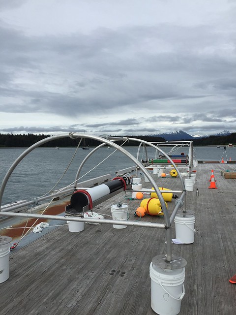
Staging an autonomous underwater hydrophone for deployment in Glacier Bay National Park and Preserve.
Storms, boat traffic, animal noises and more contribute to the underwater sound environment in the ocean, even in areas considered protected, a new study from Oregon State University, Cornelle University, National Park Service, and NOAA PMEL and NOAA Fisheries scientists shows.
Using underwater acoustic monitors, researchers listened in on Stellwagen Bank National Marine Sanctuary off the coast of Boston; Glacier Bay National Park and Preserve in Alaska; National Park of American Samoa; and Buck Island Reef National Monument in the Virgin Islands. They found that the ambient sounds varied widely across the sites and were driven by differences in animal vocalization rates, human activity and weather.
The findings demonstrate that sound monitoring is an effective tool for assessing conditions and monitoring changes, said Samara Haver, a doctoral candidate in the College of Agricultural Sciences at OSU and the study’s lead author. “This is a relatively economical way for us to get a ton of information about the environment,” said Haver, who studies marine acoustics and works out of the Cooperative Institute for Marine Resources Studies, a partnership between OSU and the National Oceanic and Atmospheric Administration at the Hatfield Marine Science Center in Newport. “Documenting current and potentially changing conditions in the ocean soundscape can provide important information for managing the ocean environment.”
Passive acoustic monitoring is seen as a cost-effective and low-impact method for monitoring the marine environment. The researchers’ goal was to test how effective acoustic monitoring would be for long-term assessment of underwater conditions.
“Ocean noise levels have been identified as a potential measure for effectiveness of conservation efforts, but until now comparing sound across different locations has been challenging,” Haver said. “Using equipment that was calibrated across all of the sites, we were able to compare the sound environments of these diverse areas in the ocean.”
The researchers collected low frequency, passive acoustic recordings from each of the locations between 2014 and 2018. They compared ambient sounds as well as sounds of humpback whales, a species commonly found in all four locations. The inclusion of the humpback whale sounds – mostly songs associated with mating in the southern waters, and feeding or social calls in the northern waters – gives researchers a way to compare the sounds of biological resources across all the soundscapes, Haver said.
The researchers found that ambient sound levels varied across all four study sites and sound levels were driven by differences in animal vocalization rates, human activity and weather. The highest sound levels were found in Stellwagen Bank during the winter/spring, driven by higher animal sound rates, vessel activity and high wind speeds. The lowest sound levels were found in Glacier Bay in the summer.
“Generally, the Atlantic areas were louder, especially around Stellwagen, than the Pacific sites,” Haver said. “That makes sense, as there is generally more man-made sound activity in the Atlantic. There also was a lot of vessel noise in the Caribbean.”
The researchers also were able to hear how sound in the ocean changes before, during and after hurricanes and other severe storms; the monitoring equipment captured Hurricanes Maria and Irma in the Virgin Islands and Tropical Cyclone Winston in American Samoa. Ultimately, the study provides a baseline for these four regions and can be used for comparison over time. Documenting current and potentially changing conditions in the ocean soundscape can provide important information for managing the ocean environment, particularly in and around areas that have been designated as protected, Haver said.
This story was originally posted by Oregon State University: https://today.oregonstate.edu/news/underwater-soundscapes-reveal-differences-marine-environments
Learn more about PMEL's work with NOAA and National Park Service's Noise Reference Station here: https://www.pmel.noaa.gov/acoustics/noaanps-ocean-noise-reference-station-network