
Revised:
|
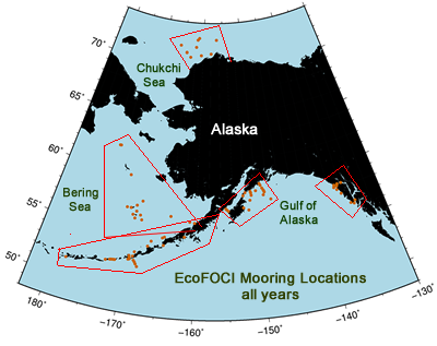
| Code-name descriptions, naming conventions Mooring location maps & data plots (up to 2008) Mooring Plans 2002-2015 Field Operations web area |
|
| highlight color for long-term sites |
|---|
| Site ID | Site (Other Info) | Code | Region | Latitude (N) | Longitude (W) | Depth (m) | Year(s) |
|---|---|---|---|---|---|---|---|
| AK-1 | Akutan Pass 1 | AK | Aleutian Islands | 54.067 | 166.297 | 83 | 2001-02 |
| AK-2 | Akutan Pass 2 | AK | Aleutian Islands | 53.934 | 165.917 | 91 | 2001-02 |
| GS-1 | Alaska Stream 1 | GS | Aleutian Islands | 52.392 | 169.746 | 986 | 2001 |
| GS-2 | Alaska Stream 2 | GS | Aleutian Islands | 52.268 | 169.669 | 2000 | 2001 |
| GS-3 | Alaska Stream 3 | GS | Aleutian Islands | 52.180 | 169.618 | 3000 | 2001 |
| GS-4 | Alaska Stream 4 | GS | Aleutian Islands | 51.983 | 169.517 | 5000 | 2001 |
| GS-5 | Alaska Stream 5 | GS | Aleutian Islands | 51.719 | 169.373 | 5100 | 2001 |
| GS-6 | Alaska Stream 6 | GS | Aleutian Islands | 52.674 | 168.808 | 1017 | 2003 |
| GS-7 | Alaska Stream 7 | GS | Aleutian Islands | 52.546 | 168.616 | 2850 | 2003 |
| GS-8 | Alaska Stream 8 | GS | Aleutian Islands | 52.387 | 168.458 | 3340 | 2003 |
| AI-1 | Aleutian Islands 1 | AI (YYB01) | Aleutian Islands | 53.140 | 170.293 | 802 | 1994 |
| AI-2 | Aleutian Islands 2 | AI (YYB02) | Aleutian Islands | 52.442 | 174.113 | 1030 | 1994 |
| AI-3 | Aleutian Islands 3 | AI (YYB03) | Aleutian Islands | 51.872 | 173.517 | 1180 | 1994 |
| AM-1 | Amukta Pass 1 | AM | Aleutian Islands | 52.445 | 171.447 | 406 | 1995, 2001-3, 2005-8 |
| AM-2 | Amukta Pass 2 | AM | Aleutian Islands | 52.417 | 171.667 | 453 | 1995, 2001-3, 2005-8 |
| AM-3 | Amukta Pass 3 | AM | Aleutian Islands | 52.400 | 171.916 | 305 | 1995, 2001-3, 2005-8 |
| AM-4 | Amukta Pass 4 | AM | Aleutian Islands | 52.384 | 172.117 | 360 | 1995, 2001-3, 2005-8 |
| B01 | B01 | B0? | Aleutian Islands | 53.140 | 170.293 | 803 | 1994 |
| B02 | B02 | B0? | Aleutian Islands | 52.438 | 174.095 | 1033 | 1994 |
| B03 | B03 | B0? | Aleutian Islands | 51.871 | 173.517 | 1033 | 1994 |
| BC-1 | Barnabus Canyon 1 | BC | Gulf of Alaska | 56.680 | 152.404 | 148 | 2001-02 |
| BC-2 | Barnabus Canyon 2 | BC | Gulf of Alaska | 56.730 | 152.542 | 154 | 2001-02 |
| BC-3 | Barnabus Canyon 3 | BC | Gulf of Alaska | 56.942 | 152.658 | 153 | 2002 |
| BC-4 | Barnabus Canyon 4 | BC | Gulf of Alaska | 56.983 | 152.458 | 141 | 2002 |
| BF-1 | Beaufort Sea 1 | BC | Gulf of Alaska | 56.983 | 152.458 | 141 | 2018 |
| BS-1 | Bering Sea 1 (M1) | BS | Bering Sea | 55.072 | 164.518 | 65 | 1995 |
| BS-2 | Bering Sea 2 (M2, B2 in1990s) | BS | Bering Sea | 56.869 | 164.050 | 71 | 1995+ |
| BS-3 | Bering Sea 3 (M3) | BS | Bering Sea | 56.049 | 166.337 | 127 | 1995-2000 |
| BS-4 | Bering Sea 4 (M4) | BS | Bering Sea | 57.895 | 168.878 | 69 | 2000+ |
| BS-5 | Bering Sea 5 (M5) | BS | Bering Sea | 59.911 | 171.731 | 68 | 2005+ |
| BS-6 | Bering Sea 6 (M6) | BS | Bering Sea | 53.408 | 168.851 | 1020 | 1996-2000, 2003, 2014 |
| BS-7 | Bering Sea 7 (M7) | BS | Bering Sea | 53.598 | 169.095 | 1980 | 1996 |
| BS-8 | Bering Sea 8 (M8) | BS | Bering Sea | 62.194 | 174.688 | 73 | 2005-24+ |
| BS-9 | Bering Sea 9 (M9) | BS | Bering Sea | 54.598 | 166.561 | 400 | 2008-09 |
| BS-14 | Bering Sea 14 (M14) | BS | Bering Sea | 64.000 | 167.92 | 36 | 2020+ |
| BSr | Bering Strait Russia | BSr | Bering Strait | 2014-16 | |||
| KC-1 | Bristol Bay 1 | KC | Bering Sea | 56.427 | 160.219 | 23 | 1996-2007 |
| KC-2 | Bristol Bay 2 | KC | Bering Sea | 56.500 | 160.999 | 66 | 1997-2010 |
| CH-1 | Chatham Strait | CH | Gulf of Alaska | 56.265 | 134.669 | 2006, 2013 | |
| CB-1 | Chiniak Bay 1 | CB | Gulf of Alaska | 57.722 | 152.291 | 193 | 1999-2013, 2015+ |
| CB-2 | Chiniak Bay 2 | CB | Gulf of Alaska | 57.460 | 151.580 | 112 | 2001-02 |
| CB-3 | Chiniak Bay 3 | CB | Gulf of Alaska | 57.513 | 151.452 | 147 | 2001-02, 2011 |
| CK-1 | Chukchi Sea 1 (Icy Cape Line) | CK | Chukchi Sea | 70.838 | 163.125 | 43 | 2010-11, 2013+ |
| CK-2 | Chukchi Sea 2 (Icy Cape Line) | CK | Chukchi Sea | 71.231 | 164.223 | 41 | 2010+ |
| CK-3 | Chukchi Sea 3 (Icy Cape Line) | CK | Chukchi Sea | 71.828 | 166.070 | 43 | 2010-11, 2016+ |
| CK-4 | Chukchi Sea 4 | CK | Chukchi Sea | 71.038 | 160.514 | 47.5 | 2012+ |
| CK-5 | Chukchi Sea 5 | CK | Chukchi Sea | 71.203 | 158.011 | 46 | 2013-14, 2016+ |
| CK-6 | Chukchi Sea 6 | CK | Chukchi Sea | 71.774 | 161.864 | 43 | 2013-14 |
| CK-7 | Chukchi Sea 7 | CK | Chukchi Sea | 72.421 | 161.631 | 43 | 2013-14 |
| CK-8 | Chukchi Sea 8 | CK | Chukchi Sea | 72.583 | 161.205 | 46 | 2013-14 |
| CK-9 | Chukchi Sea 9 (Barrow Canyon) | CK | Chukchi Sea | 72.464 | 156.548 | 1032 | 2014-16, 2020-24+ |
| CK-10 | Chukchi Sea 10 | CK | Chukchi Sea | 70.211 | 167.787 | 47 | 2016+ |
| CK-11 | Chukchi Sea 11 | CK | Chukchi Sea | 70.013 | 166.855 | 46 | 2016+ |
| CK-12 | Chukchi Sea 12 | CK | Chukchi Sea | 67.911 | 168.195 | 58 | 2016+ |
| CS-1 | Cross Sound 1 (middle) | CS | SE Alaska | 58.149 | 136.583 | 309 | 2005-06, 2010-11, 2013 |
| CS-2 | Cross Sound 2 (north) (SEA1010) | CS | SE Alaska | 58.174 | 136.618 | 95 | 2010-11, 2013 |
| CS-3 | Cross Sound 3 (south) | CS | SE Alaska | 58.119 | 136.555 | 315 | 2010-11, 2013 |
| CS-4 | Cross Sound 4 | CS | SE Alaska | 58.119 | 136.555 | 315 | 2020-22 |
| CS-11 | Cross Sound 11 (S Baranoff Isl) | CS | SE Alaska | 56.396 | 135.141 | 115 | 2011, 2013 |
| CS-12 | Cross Sound 12(N Baranoff Isl) | CS | SE Alaska | 57.402 | 136.179 | 130 | 2011, 2013 |
| CS-13 | Cross Sound 13 (S of Cross Sound) | CS | SE Alaska | 57.821 | 136.669 | 131.57 | 2011, 2013 |
| FT-1 | FATE 1 | FT | Gulf of Alaska | 58.260 | 147.695 | 2403 | 2001-03 |
| GL-1 | Glacier Bay (SEA1002) | GL | SE Alaska | 58.382 | 135.946 |
63 | 2010 |
| GL-2 | Glacier Bay (SEA1003) | GL | SE Alaska | 58.382 | 135.977 | 69 | 2010 |
| GL-3 | Glacier Bay (SEA1004) | GL | SE Alaska | 58.383 | 136.016 | 58 | 2010 |
| GB-1 | GLOBEC 1 (GAK2) | GB | Gulf of Alaska | 59.689 | 149.333 | 230 | 2001-05 |
| GB-2 | GLOBEC 2 (GAK3) | GB | Gulf of Alaska | 59.514 | 149.162 | 212 | 2001-04 |
| GB-3 | GLOBEC | GB | Gulf of Alaska | 59.308 | 148.996 | 187 | 2001-04 |
| GB-4 | GLOBEC 4 (GAK6) | GB | Gulf of Alaska | 59.122 | 148.767 | 146 | 2001-04 |
| GB-5 | GLOBEC 5 | GB | Gulf of Alaska | 59.041 | 148.693 | 197 | 2001-04 |
| GB-6 | GLOBEC 6 | GB | Gulf of Alaska | 58.925 | 148.569 | 248 | 2001 |
| GB-7 | GLOBEC 7 | GB | Gulf of Alaska | 59.766 | 148.978 | 195 | 2001-02 |
| GB-8 | GLOBEC 8 | GB | Gulf of Alaska | 59.655 | 148.650 | 183 | 2001-02 |
| GB-9 | GLOBEC 9 | GB | Gulf of Alaska | 59.366 | 148.244 | 173 | 2001-02 |
| GB-10 | GLOBEC | GB | Gulf of Alaska | 59.160 | 149.130 | 172 | 2001-02 |
| GB-11 | GLOBEC 11 | GB | Gulf of Alaska | 58.921 | 148.620 | 256 | 2002 |
| GB-12 | GLOBEC 12 | GB | Gulf of Alaska | 58.684 | 148.847 | 211 | 2002-04 |
| GB-13 | GLOBEC 13 | GB | Gulf of Alaska | 59.109 | 150.082 | 163 | 2002 |
| GP-32 | Gore Point 32 | GP | Gulf of Alaska | 59.102 | 151.003 | 160 | 1994,2001-04, 2011, 2013 |
| GP-33 | Gore Point 33 | GP | Gulf of Alaska | 59.011 | 150.965 | 158 | |
| GP-34 | Gore Point 34 | GP | Gulf of Alaska | 58.969 | 150.948 | 147 | 1994,2001-04, 2011, 2013 |
| GP-35 | Gore Point 35 | GP | Gulf of Alaska | 58.883 | 150.9 | 147 | |
| GP-36 | Gore Point 36 | GP | Gulf of Alaska | 58.746 | 150.865 | 182 | 1994,2001-04, 2011, 2013 |
| GP-37 | Gore Point 37 | GP | Gulf of Alaska | 58.707 | 150.835 | 188 | 1994 |
| GP-38 | Gore Point 38 | GP | Gulf of Alaska | 58.589 | 150.802 | 179 | |
| IF-1 | Inner Front 1 | IF | Bering Sea | 58.670 | 168.320 | 52 | 1997-98 |
| IF-2 | Inner Front 2 | IF | Bering Sea | 58.565 | 168.508 | 60 | 1997-99 |
| IF-3 | Inner Front 3 | IF | Bering Sea | 58.709 | 168.277 | 52 | 1997 |
| IF-4 | Inner Front 4 | IF | Bering Sea | 58.825 | 168.147 | 46 | 1997-98 |
| IF-5 | Inner Front 5 | IF | Bering Sea | 58.703 | 168.083 | 49 | 1997-98 |
| IF-6 | Inner Front 6 | IF | Bering Sea | 58.547 | 168.257 | 56 | 1997-98 |
| IF-7 | Inner Front 7 | IF | Bering Sea | 58.475 | 168.533 | 63 | 1997-98 |
| IF-8 | Inner Front 8 | IF | Bering Sea | 58.637 | 168.555 | 57 | 1997-98 |
| IF-9 | Inner Front 9 | IF | Bering Sea | 58.791 | 168.383 | 50 | 1997-98 |
| IF-10 | Inner Front 10 | IF | Bering Sea | 57.408 | 163.407 | 53 | 1999 |
| IF-11 | Inner Front 11 | IF | Bering Sea | 55.150 | 163.898 | 38 | 1999 |
| IF-12 | Inner Front 12 | IF | Bering Sea | 55.252 | 163.965 | 59 | 1999 |
| IF-13 | Inner Front 13 | IF | Bering Sea | 55.412 | 163.113 | 97 | 1999 |
| IP-1 | Icy Point, inshore | IP | SE Alaska | 58.250 | 136.943 | 153 | 2011, 2013 |
| IP-2 | Icy Point, offshore | IP | SE Alaska | 58.056 | 137.079 | 320 | |
| KE-41 | Kennedy Entrance 41 | KE | Gulf of Alaska | 59.021 | 151.901 | 194 | 2011, 2013 |
| KU-1 | Kuskokwim Delta 1 | KU | Bering Sea | 57.717 | 163.725 | 49 | 2023 |
| KU-2 | Kuskokwim Delta 2 | KU | Bering Sea | 58.250 | 163.500 | 40 | 2023 |
| KU-3 | Kuskokwim Delta 3 | KU | Bering Sea | 58.783 | 163.280 | 28 | 2023 |
| KU-4 | Kuskokwim Delta 4 | KU | Bering Sea | 57.900 | 165.700 | 61 | 2023 |
| MT-1 | St. Matthews 1 | MT | Bering Sea | 60.250/td> | 173.372 | 65 | 2018 |
| MT-2 | St. Matthews 2 | MT | Bering Sea | 60.029/td> | 172.772 | 65 | 2018 |
| MT-3 | St. Matthews 3 | MT | Bering Sea | 60.232/td> | 172.521 | 50 | 2018 |
| PA-1 | Pavlof Bay 1 | PA | Aleutian Islands | 55.186 | 161.695 | 98 | 1998-2014 |
| NS-B | Near Strait B | NS | Aleutian Islands | 53.033 | 170.617 | 708 | 1991 |
| NS-C | Near Strait C | NS | Aleutian Islands | 53.067 | 171.250 | 1494 | 1991 |
| NS-D | Near Strait D | NS | Aleutian Islands | 53.333 | 170.500 | 1040 | 1991 |
| PC-1 | Portlock Canyon | PC | Gulf of Alaska | 58.342 | 151.142 | 121 | 2011, 2013 |
| PT-1 | Patton Seamount | PT | Gulf of Alaska | 54.570 | 150.470 | 2023 | |
| PI-1 | Pribilof Islands 1 | PI | Bering Sea | 56.900 | 169.590 | 67 | 2004 |
| PI-2 | Pribilof Islands 2 | PI | Bering Sea | 56.577 | 170.100 | 100 | 2004 |
| PI-3 | Pribilof Islands 3 | PI | Bering Sea | 57.118 | 171.219 | 100 | 2004 |
| PI-4 | Pribilof Islands 4 | PI | Bering Sea | 56.634 | 168.877 | 100 | 2004 |
| PI-5 | Pribilof Islands 5 | PI | Bering Sea | 57.133 | 170.571 | 67 | 2004 |
| PI-6 | Pribilof Islands 6 | PI | Bering Sea | 57.420 | 169.674 | 67 | 2004 |
| PI-7 | Pribilof Islands 7 | PI | Bering Sea | 56.286 | 169.696 | 200 | 2004 |
| PI-8 | Pribilof Islands 8 | PI | Bering Sea | 56.232 | 168.584 | 200 | 2004 |
| SB-1 | Slime Bank (Unimak) | SB | Bering Sea | 55.047 | 165.094 | 70 | 2008-09 |
| SE-1 | Southeast Alaska 1 (N.Inian Pass) | SE | SE Alaska | 58.310 | 135.738 | 290 | 2010 |
| SE-2 | Southeast Alaska 2 (Icy Strait) | SE | SE Alaska | 58.284 | 136.370 | 140 | 2010 |
| SE-3 | Southeast Alaska 3 (Icy Strait) | SE | SE Alaska | 58.283 | 136.385 | 296 | 2010 |
| SE-4 | Southeast Alaska 4 (SEA1005) | SE | SE Alaska | 58.224 | 136.308 | 67 | 2010 |
| SG-1 | Samalga 1 | SG | Aleutian Islands | 52.846 | 169.455 | 229 | 2003 |
| SG-2 | Samalga 2 | SG | Aleutian Islands | 53.029 | 169.535 | 119 | 2003 |
| SG-3 | Samalga 3 | SG | Aleutian Islands | 53.022 | 168.998 | 107 | 1999, 2003 |
| SG-4 | Samalga 4 | SG | Aleutian Islands | 52.689 | 169.575 | 111 | 1999, 2003 |
| SG-5 | Samalga 5 | SG | Aleutian Islands | 52.727 | 169.389 | 102 | 2003 |
| SH-1 | Shumagin Islands 1 | SH | Aleutian Islands | 54.853 | 158.991 | 74 | 2019+ |
| SM-1 | Seguam Pass 1 | SM | Aleutian Islands | 52.267 | 172.750 | 160 | 2001-02 |
| SM-2 | Seguam Pass 2 | SM | Aleutian Islands | 52.133 | 172.417 | 165 | 2001-02 |
| SM-3 | Seguam Pass 3 | SM | Aleutian Islands | 52.135 | 172.426 | 163 | 2002 |
| SS-1 | Shelikof Strait 1 | SS | Gulf of Alaska | 57.680 | 155.204 | 287 | 1991,93,96,98, 2001-06 |
| SS-2 | Shelikof Strait 2 | SS | Gulf of Alaska | 57.614 | 155.075 | 242 | 1994,96,98,2001-06 |
| SS-3 | Shelikof Strait 3 | SS | Gulf of Alaska | 57.484 | 154.808 | 192 | 1993-4,96,98,2001-06 |
| SW-8 | Southwest Gulf of Alaska 8 | SW (YY08 or YY8) | Gulf of Alaska | 55.948 | 156.145 | 190 | 1998 |
| SW-16 | Southwest Gulf of Alaska 16 | SW (YY16) | Gulf of Alaska | 56.672 | 156.530 | 164 | 1996 |
| SW-18 | Southwest Gulf of Alaska 18 | SW (YY18) | Gulf of Alaska | 56.527 | 156.313 | 216 | 1996 |
| SA-1 | St. George Island 1 | SA (SG) | Bering Sea | 56.190 | 169.362 | 597 | 1997,1999 |
| SA-2 | St. George Island 2 | SA (SG) | Bering Sea | 56.297 | 169.335 | 39 | 1997 |
| SA-3 | St. George Island 3 | SA (SG) | Bering Sea | 56.467 | 169.334 | 101 | 1998,1999 |
| SA-4 | St. George Island 4 | SA (SG) | Bering Sea | 55.858 | 168.650 | 151 | 1999 |
| SP-1 | St. Paul Island 1 | SP | Bering Sea | 57.018 | 170.145 | 65 | 1995 |
| SP-2 | St. Paul Island 2 | SP | Bering Sea | 57.135 | 170.330 | 21 | 1995 |
| SP-3 | St. Paul Island 3 | SP | Bering Sea | 57.090 | 170.292 | 26 | 1995 |
| SP-4 | St. Paul Island 4 | SP | Bering Sea | 57.152 | 170.432 | 24 | 1995 |
| SP-5 | St. Paul Island 5 | SP | Bering Sea | 57.242 | 170.298 | 26 | 1995 |
| SP-6 | St. Paul Island 6 | SP | Bering Sea | 57.262 | 170.087 | 28 | 1995 |
| SP-7 | St. Paul Island 7 | SP | Bering Sea | 57.153 | 170.113 | 26 | 1995 |
| STL-1 | St. Lawrence Island 1 | STL ('04 only) | Bering Sea | 62.194 | 174.856 | 78 | 2004 |
| SU-1 | Suttwick 1 | SU 1 | Gulf of Alaska | 56.600 | 157.000 | 139 | 2022+ |
| SV-39 | Stevenson Entrance | SV | Gulf of Alaska | 58.770 | 152.261 | 122 | 2011, 2013 |
| TG-1 | Tanaga Pass 1 | TG | Aleutian Islands | 51.589 | 178.211 | 160 | 2002 |
| TG-2 | Tanaga Pass 2 | TG | Aleutian Islands | 51.651 | 178.253 | 150 | 2002 |
| UL-1 | Unalaska Line (Bering Canyon) | UL | Bering Sea | 54.066 | 167.068 | 1000 | 2014 |
| UB-1 | Unimak Box 1 (Shelf) | UB | Bering Sea | 54.944 | 164.005 | 94.6 | 2014 |
| UP-1 | Unimak Pass 1 | UP | Aleutian Islands | 54.348 | 164.048 | 102 | 1996 |
| UP-2 | Unimak Pass 2 | UP | Aleutian Islands | 54.270 | 164.780 | 77 | 1995,1996 |
| UP-3 | Unimak Pass 3 | UP | Aleutian Islands | 54.302 | 164.748 | 79.5 | 1996, 2001-02, 2014, 2022-24+ |
| UP-4 | Unimak Pass 4 | UP | Aleutian Islands | 54.368 | 164.730 | 56 | 1996 |
| UP-5 | Unimak Pass 5 | UP | Aleutian Islands | 54.348 | 165.745 | 98 | 1996 |
| EcoFOCI Project Office NOAA/PMEL and NOAA/AFSC 7600 Sand Point Way NE Seattle, Washington 98115 Comments and information |
||